
ESAS14
Location: Minimay
Australian Soil Classification: Vertic, Mesonatric, SODOSOL
General Landscape Description: Level plan.
Site Description: Continuous cropping paddock under a centre pivot. Lower yielding area when compared to ESAS13.
Soil Profile Morphology:
| Surface Soil | |||
| Ap | 0-15 cm | Sandy clay loam; firm surface condition; pH 7.9: | |
| Subsoil | |||
| B21 | 15-35 cm | Light clay; strong medium prismatic, parting to strong medium angular blocky structure; a few distinct slickensides evident; pH 8.9: | |
| B22 | 35-50 cm | Light medium clay; strong medium prismatic, parting to strong medium angular blocky structure; pH 9.1: | |
| B23 | 50-80 cm | Medium clay; strong medium prismatic, parting to strong fine prismatic structure; strong consistence, moist; few distinct slickensides evident; pH 9.6: | |
| B24 | 80-100 cm | Medium clay; pH 9.6: | |
| B25 | 100+ cm | Medium clay; pH 9.4. | |
Soil Profile Characteristics:
pH | Salinity Rating | |||
Surface (A1 horizon) | Slightly Alkaline | Medium | Sodic | Moderate |
Subsoil (B21 horizon) | Strongly Alkaline | Medium to High | Strongly Sodic | Strong 1 |
Deeper Subsoil (at 80-100 cm) | Extremely Alkaline | High | Extremely Sodic | Nil 2 |
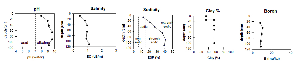
| The surface is slightly alkaline. The upper subsoil is strongly alkaline becoming extremely alkaline with depth. | The salinity rating for the surface is medium. The subsoil has a medium to high salinity rating.
| The surface is sodic. The upper subsoil is strongly sodic becoming extremely sodic with depth. | The clay content increases significantly at the A/B boundary. | Boron levels are fairly consistent throughout the profile. |
Chemical and Physical Analysis:
Horizon | Horizon Depth (cm) | pH (water) | pH (CaCl2) | EC dS/m | Chloride mg/kg | Exchangeable Cations | |||
Ca | Mg | K | Na | ||||||
meq/100g | |||||||||
Ap | 0-15 | 7.9 | 7.4 | 0.44 | 0.032 | 11 | 7.3 | 1 | 2.6 |
B21 | 15-35 | 8.9 | 8.3 | 0.79 | 0.109 | 11 | 16 | 0.97 | 7.6 |
B22 | 35-50 | 9.1 | 8.6 | 0.96 | 0.126 | 8.6 | 18 | 1.1 | 10 |
B23 | 50-80 | 9.6 | 8.9 | 0.94 | 0.12 | 4 | 12 | 0.81 | 9.7 |
B24 | 80-100 | 9.6 | 8.9 | 0.91 | 0.118 | 4.2 | 11 | 0.85 | 11 |
B25 | 100+ | 9.4 | 8.7 | 1.1 | 0.159 | 6.5 | 13 | 0.92 | 13 |
Horizon | Horizon Depth (cm) | Oxidisable Organic Carbon % | Total Nitrogen % | Boron % | Field Capacity pF2.5 | Wilting Point pF4.2 | Coarse Sand (0.2-2.0 mm) | Fine Sand (0.02-0.2 mm) | Silt (0.002-0.02 mm) | Clay (<0.002 mm) |
Ap | 0-15 | 1.7 | 0.15 | 27.8 | 15.1 | 18 | 32 | 10 | 33 | |
B21 | 15-35 | 7.5 | 45.0 | 21.6 | 12 | 21 | 8 | 53 | ||
B22 | 35-50 | 10 | 51.8 | 24.0 | 11 | 19 | 9 | 54 | ||
B23 | 50-80 | 9.3 | 38.4 | 18.7 | ||||||
B24 | 80-100 | 8.3 | 40.6 | 18.3 | ||||||
B25 | 100+ | 8.2 | 44.0 | 20.0 |
Profile Described By: Bernard Noonan and Melissa Cann (March 2009).
© State of Victoria (Agriculture Victoria) 1996 - .

This work, Victorian Resources Online, is licensed under a Creative Commons Attribution 4.0 licence. You are free to re-use the work under that licence, on the condition that you credit the State of Victoria (Agriculture Victoria) as author, indicate if changes were made and comply with the other licence terms.
The licence does not apply to ‘branding’ or some ‘images or photographs’ that may be owned by third parties. We ask you to seek prior approval to use images using the VRO feedback form. Access to higher quality images can also be provided on request.
This page was last updated on .