
ESAS13
Location: Minimay
Australian Soil Classification: Vertic (& Sodic), Hypercalcic, Grey DERMOSOL
General Landscape Description: Level plain.
Site Description: Gilgai - mounds and depressions evident.
Land Use: Continuous cropping paddock. Area under a centre pivot.
Soil Profile Morphology:
| Surface Soil | 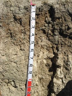 ESAS13 Profile | ||
| Ap | 0-8 cm | Grey; Sandy clay loam; firm surface condition; moderate coarse angular blocky, parting to moderate medium angular blocky structure; weak consistence dry; pH 7.8; smooth change to: | |
| A2 | 8-18 cm | Variable color ranges from grey to reddish brown; variable texture ranges from sandy clay loam to light medium clay; strong consistence dry; apedal; very strongly cemented cultivation pan evident; pH 6.8; abrupt change to: | |
| Subsoil | |||
| B21 | 18-35 cm | Variable color ranges from grey to reddish brown; light clay, sandy; strong very coarse prismatic, parting to strong medium prismatic structure; very strong consistence dry; a few distinct slickensides evident; moderately calcareous; pH 8.1; clear change to: | |
| B22 | 35-48 cm | Variable color ranges from grey to reddish brown; medium clay, sandy; strong very coarse prismatic, parting to strong medium prismatic structure; very strong consistence dry; common distinct slickensides evident; moderately calcareous; pH 8.3; clear change to: | |
| B23 | 48-65 cm | Strong very coarse prismatic structure; rigid consistence dry; distinct slickensides common; moderately calcareous; pH 8.8; gradual change to: | |
| B24 | 65-84 cm | Medium clay; strong consistence dry; distinct slickensides common; moderately calcareous; pH 9.3; abrupt change to: | |
| B25k | 84-150 cm | Medium clay; strong coarse angular blocky structure; strong consistence dry; very highly calcareous; pH 9.5. | |
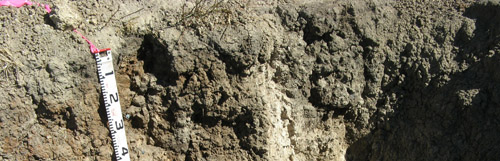
ESAS13 Profile variability due to gilgai - mounds have a grey B21 with carbonate appearing high in the profile.
Depressions have a reddy brown B21 with not as much carbonate high up.
Soil Profile Characteristics:
pH | Salinity Rating | |||
Surface (A1 horizon) | Slightly Alkaline | Low-Medium | Sodic | None |
Subsoil (B21 horizon) | Moderately Alkaline | Low-Medium | Sodic | None1 |
Deeper Subsoil (at 84-120 cm) | Very strongly Alkaline | Medium-High | Strongly Sodic | None2 |
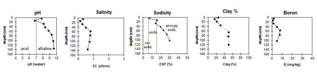
| The salinity rating in the surface and upper subsoil is low to medium. The salinity rating of the deeper subsoil is medium to high.
| The surface and the upper subsoil is sodic. The deeper subsoil is strongly sodic. | The clay content generally increases with depth down the profile. |
|
Horizon | Horizon Depth (cm) | pH (water) | pH (CaCl2) | EC dS/m | NaCl % | Exchangeable Cations | |||
Ca | Mg | K | Na | ||||||
meq/100g | |||||||||
Ap | 0-8 | 7.8 | 7.3 | 0.31 | 0.03 | 13 | 5.7 | 0.97 | 1.5 |
A2 | 8-18 | 6.8 | 5.7 | 0.11 | - | 3 | 1.9 | 0.15 | 0.99 |
B21 | 18-35 | 8.1 | 7.5 | 0.27 | 0.03 | 5.2 | 5.3 | 0.36 | 1.8 |
B22 | 35-48 | 8.3 | 7.7 | 0.48 | 0.08 | 6.5 | 9.1 | 0.57 | 4 |
B23 | 48-65 | 8.8 | 8.2 | 0.79 | 0.11 | 7.8 | 14 | 0.74 | 6.9 |
B24 | 65-84 | 9.3 | 8.6 | 0.77 | 0.09 | 6.9 | 14 | 0.63 | 7.8 |
B25 | 84-120 | 9.5 | 8.6 | 0.73 | 0.07 | 6.3 | 10 | 0.57 | 7.1 |
BCk | 120-150 | 9.6 | 8.7 | 0.61 | 0.05 | ||||
Horizon | Horizon Depth (cm) | Oxidisable Organic Carbon % | Total Nitrogen % | Boron % | Exchangeable Acidity meq/100g | Field Capacity pF2.5 | Wilting Point pF4.2 | Coarse Sand (0.2-2.0 mm) | Fine Sand (0.02-0.2 mm) | Silt (0.002-0.02 mm) | Clay (<0.002 mm) |
Ap | 0-8 | 2.3 | 0.2 | 1.5 | 28.3 | 13.5 | 23 | 30 | 15 | 25 | |
A2 | 8-18 | 0.7 | 2.5 | 15.1 | 4.9 | 30 | 42 | 10 | 16 | ||
B21 | 18-35 | 1.3 | 20.6 | 9.2 | 29 | 36 | 11 | 21 | |||
B22 | 35-48 | 4.7 | 29.0 | 13.8 | 23 | 32 | 11 | 30 | |||
B23 | 48-65 | 7.8 | 40.8 | 19.0 | |||||||
B24 | 65-84 | 7.5 | 39.5 | 18.0 | |||||||
B25 | 84-120 | 4.7 | |||||||||
BCk | 120-150 |
Profile Described By: Bernard Noonan and Melissa Cann (March 2009).
© State of Victoria (Agriculture Victoria) 1996 - .

This work, Victorian Resources Online, is licensed under a Creative Commons Attribution 4.0 licence. You are free to re-use the work under that licence, on the condition that you credit the State of Victoria (Agriculture Victoria) as author, indicate if changes were made and comply with the other licence terms.
The licence does not apply to ‘branding’ or some ‘images or photographs’ that may be owned by third parties. We ask you to seek prior approval to use images using the VRO feedback form. Access to higher quality images can also be provided on request.
This page was last updated on .