ALRA068
|
| ALRA068 | ||
|
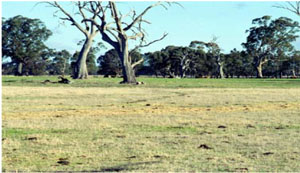
Location | Moyston West Road | |||
|
Landform | Alluvial plain | |||
|
Geology | Quaternary alluvium | |||
|
Element | Plain | |||
|
Slope | 2% | |||
|
Aspect | North | |||
Horizon | Depth (cm) | |||
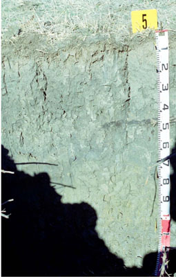
A1 | 0–5 | Very dark greyish brown (10YR3/2); loam, medium sandy; weak coarse prismatic structure parting to weak fine subangular blocky structure; rough fabric; weak consistence when moderately moist; common fine ferruginous-organic root lining segregations; pH 6.0; abrupt boundary to: |  Epihypersodic, Massive, Grey VERTOSOL | |
B1 | 5–15 | Dark greyish brown (10YR4/2); loamy clay; moderate coarse prismatic parting to weak fine to medium subangular blocky structure; rough fabric; very strong consistence when dry; few fine ferruginous-organic root lining segregations; pH 6.5; clear boundary to: | ||
B21 | 15–70 | Dark grey (5Y4/1); medium heavy clay; moderate coarse prismatic parting to weak medium to coarse polyhedral structure; very strong consistence when dry; common distinct slickensides; pH 7.0; clear boundary to: | ||
B22 | 70–100 | Olive grey (5Y5/2)with many medium distinct yellowish brown (10YR5/8) mottles; medium heavy clay; subplastic; strong coarse prismatic parting to fine prismatic structure; smooth fabric; firm consistence when moderately moist; common prominent slickensides; pH 7.0; gradual boundary to: | ||
B3 | 100–135+ | Greyish brown (2.5Y5/2) with common medium distinct dark yellowish brown (10YR3/4) mottles; heavy clay; strong coarse prismatic parting to fine prismatic structure; smooth fabric; firm consistence when moist; pH 7.0. | ||
| Management Considerations: | ||||
| ||||
Chemical Analysis:
Horizon | Depth (cm) | pH (water) | pH (CaCl2) | EC dS/m | NaCl % | Exchangeable Aluminium cmol-/kg | Exchangeable Acidity cmol-/kg | Phosporus (Olsen) mg/kg | Total Nitrogen | Organic Carbon % | Exchangeable Cations cmol-/kg | Field Capacity (pF2.5) | Wilting Point (pF4.2) | Coarse Sand % | Fine Sand % | Silt % | Clay % | |||
Ca | Mg | K | Na | |||||||||||||||||
Bulk sample | 0–10 | 5.4 | 5.1 | 0.49 | 140 | 0.77 | 12 | |||||||||||||
A1 | 0-5 | 5.4 | 5.2 | 0.73 | 0.14 | 17.0 | 20 | >12.0 | 14.0 | 9.5 | 0.6 | 0.7 | 56.6 | 34 | 13.4 | 10.9 | 22.5 | 30.5 | ||
B1 | 5-15 | 6.7 | 6.3 | 0.54 | 0.09 | 9.0 | 4.9 | 7.9 | 12.0 | 0.4 | 1.9 | 35.2 | 20.4 | 7.0 | 8.8 | 29.5 | 51.0 | |||
B21 | 15-70 | 8.0 | 7.6 | 1.1 | 0.21 | - | 6.5 | 17.0 | 0.8 | 4.8 | 37.5 | 19.3 | 2.3 | 11.0 | 29.5 | 57.0 | ||||
B22 | 70-100 | 7.6 | 7.4 | 2.2 | 0.53 | - | 6.1 | 19.0 | 0.4 | 7.9 | 43.1 | 22.4 | 0.3 | 10.4 | 31.5 | 56.5 | ||||
B3 | 100-135+ | 7.4 | 7.2 | 2.3 | 0.03 | 3.2 | 5.9 | 17.0 | 0.4 | 8.7 | 43.9 | 25.1 | 0.4 | 10.7 | 36.0 | 49.0 | ||||


