
ALRA067
|
| ALRA067 | ||
|
Location | Moyston West Road | |||
|
Landform | Gently undulating plain | |||
|
Geology | Quaternary alluvium | |||
|
Element | Plain | |||
|
Slope | 1% | |||
|
Aspect | South | |||
Horizon | Depth (cm) | |||
A1 | 0–5 | Dark greyish brown (7.5YR3/1); coarse sand; massive (structureless); very weak consistence when moderately moist; pH 6.5; clear and smooth boundary to: | 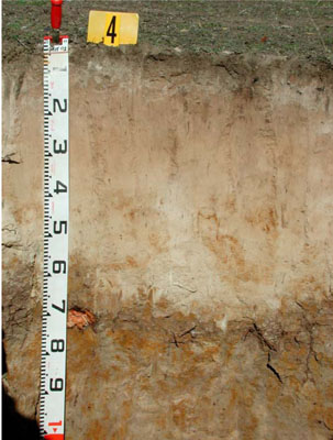 Eutrophic, Mottled-Subnatric, Grey SODOSOL | |
A21 | 5–30 | Light grey (10YR7/2); sporadically bleached (7.5YR6/3 dry); loamy sand; massive structure(structureless); very weak consistence when dry; pH 6.5; clear and wavy boundary to: | ||
A22 | 30–45 | Pinkish grey (7.5YR7/2); sporadically bleached (7.5YR7/3 dry); loamy sand; massive (structureless); weak consistence when moderately moist; pH 6.5; gradual and wavy boundary to: | ||
A23 | 45–60 | White (10YR8/2) with few coarse faint brownish yellow mottles; sporadically bleached (10YR7/3 dry); clay loam; massive (structureless); weak consistence when dry; pH 5.5; sharp and wavy boundary to: | ||
B21 | 60–75 | Greyish brown (10YR5/2) with many medium to coarse distinct brownish yellow (10YR6/6) mottles; medium clay, coarse sandy; moderate fine angular blocky structure; rough ped-fabric; firm to very firm consistence when moist; common prominent clay skins; pH 5.5; clear and wavy boundary to: | ||
B22 | 75–140+ | Greyish brown (2.5Y5/2) with many very coarse distinct yellowish brown (10YR5/6) mottles; light medium clay; weak medium subangular blocky structure; rough ped-fabric; weak consistence when moist; pH 7.0. | ||
| Management Considerations: | ||||
| ||||
Chemical Analysis:
Horizon | Depth (cm) | pH (water) | pH (CaCl2) | EC dS/m | Exchangeable Aluminium cmol-/kg | Exchangeable Acidity cmol-/kg | Phosporus (Olsen) mg/kg | Total Nitrogen | Organic Carbon % | Exchangeable Cations cmol-/kg | Field Capacity (pF2.5) | Wilting Point (pF4.2) | Coarse Sand % | Fine Sand % | Silt % | Clay % | |||
Ca | Mg | K | Na | ||||||||||||||||
Bulk sample | 0–10 | 5.6 | 5.2 | 0.16 | 14 | 0.18 | 2.8 | ||||||||||||
A1 | 0-5 | 5.6 | 5.2 | 0.18 | <10 | 8.2 | 4.7 | 7.3 | 2.1 | 0.41 | 0.35 | 14 | 10.5 | 48.6 | 39.4 | 5.5 | 1.0 | ||
A21 | 5-30 | 5.9 | 5.5 | <0.05 | <10 | <1.0 | 0.58 | 0.16 | 0.05 | 0.05 | 4.7 | 0.6 | 48.8 | 43.5 | 7.0 | 0.5 | |||
A22 | 30-45 | 6.4 | 6.1 | <0.05 | <10 | <1.0 | 0.41 | 0.13 | <0.05 | 0.05 | 4.7 | 0.7 | 51.8 | 40.8 | 5.5 | 0 | |||
A23 | 45-60 | 6.2 | 5.8 | <0.05 | <10 | <1.0 | 0.23 | 0.12 | <0.05 | 0.06 | 4.2 | 0.4 | 46.3 | 43.0 | 8.5 | 1.0 | |||
B21 | 60-75 | 5.1 | 4.2 | 0.17 | 280 | 12 | 0.79 | 4 | 0.32 | 1.7 | 23.7 | 13.2 | 37.1 | 21.8 | 2.0 | 36.5 | |||
B22 | 75-140+ | 5.5 | 4.5 | 0.16 | 95 | 4.5 | 0.64 | 2.5 | 0.14 | 1.5 | 14.5 | 6.4 | 48.3 | 32.2 | 3.5 | 14.5 | |||
© State of Victoria (Agriculture Victoria) 1996 - .

This work, Victorian Resources Online, is licensed under a Creative Commons Attribution 4.0 licence. You are free to re-use the work under that licence, on the condition that you credit the State of Victoria (Agriculture Victoria) as author, indicate if changes were made and comply with the other licence terms.
The licence does not apply to ‘branding’ or some ‘images or photographs’ that may be owned by third parties. We ask you to seek prior approval to use images using the VRO feedback form. Access to higher quality images can also be provided on request.
This page was last updated on .