
Land Inventory of the Wimmera Systems and Rocklands Water Supply Catchments
To view the information PDF requires the use of a PDF reader. This can be installed for free from the Adobe website (external link).
This report is adapted from "Land Inventory of the Wimmera Systems and Rocklands Water Supply Catchments - A Reconnaissance Survey", October 1985 - L.A. White, P. J. Kelynack, F. Gigliotti, P. D. Cook, National Soil Conservation Programme, Department of Primary Industry, Canberra and Land Protection Service, Department of Conservation, Forests and Lands, Victoria.
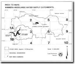
| Foreword (PDF 86KB) Acknowledgements (PDF 86KB) Section 1: Background Material (PDF 1.6MB) Introduction Geology Climate Surface Water Resources Water Quality Soil Survey Method Land Evaluation and Supply Interpretation Land Capability Classes - Generalised Definitions | Section 2: Results (PDF 1.6MB) Explanatory Notes Landform Unit Inventory Land Capability Assessment To view maps, please click on "Map Index" below Section 3: Appendices (PDF 329KB) Appendix 1: Glossary of Terms Appendix 2: Land Capability Tables upon which assessment was made Appendix 3: Photography and Maps used |
© State of Victoria (Agriculture Victoria) 1996 - .

This work, Victorian Resources Online, is licensed under a Creative Commons Attribution 4.0 licence. You are free to re-use the work under that licence, on the condition that you credit the State of Victoria (Agriculture Victoria) as author, indicate if changes were made and comply with the other licence terms.
The licence does not apply to ‘branding’ or some ‘images or photographs’ that may be owned by third parties. We ask you to seek prior approval to use images using the VRO feedback form. Access to higher quality images can also be provided on request.
This page was last updated on .