
SG5
|
Location: Ross Hill | Australian Soil Classification: Acidic, Eutrophic, Grey DERMOSOL |
| Northcote Factual Key: Gn 4.81 | Great Soil Group: brown podzolic |
| Geology: Cretaceous sediments (including mudstone). | Soil Mapping Unit: Strzelecki |
| Site Description: Upper slope of hillslope (24% slope). This site is located on a recently exposed road cutting. | |
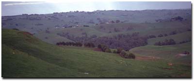
Site SG5 Landscape
Soil Profile Morphology:
Surface Soil
| A1 | 0-20 cm | Brown (10YR4/3); heavy clay loam; strong fine polyhedral structure; friable surface condition; pH 5.5: | 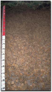 Site SG5 Profile |
| Subsoil | |||
| B1 | 20-45 cm | Yellowish brown (10YR5/4); heavy clay loam (becoming light clay with depth); strong medium subangular blocky structure; firm consistence moist; pH 5.6; gradual change to: | |
| B21 | 45-75 cm | Light brownish grey (10YR6/2) with strong brown (7.5YR5/8) mottles; medium clay; moderate blocky structure; firm consistence moist: pH 5.5: | |
| B/C | 75-90 cm | Light brownish grey (10YR6/2) with reddish yellow (7.5YR6/8) mottles; light medium clay; contains 50% weathered mudstone; pH 5.5: | |
| C | 90+ cm | Weathering sediments. | |
| Note: As the roadside cutting had a 30 degree slope, the measurements on the tape in the photograph should be halved to obtain the true vertical depth. | |||
Key Profile Features:
- Lack of significant texture change throughout the profile.
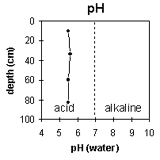 | 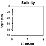 |
The pH is mainly strongly acid throughout the profile. | Soluble salt levels are very low throughout the profile. |
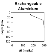 | 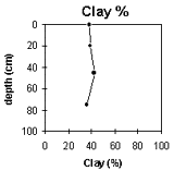 |
The exchangeable aluminium level is quite high in the surface soil and increases in the subsoil. | There is no significant change in clay content throughout the profile. |
Horizon Depth (cm) | pH water | pH CaCl2 | EC 1:5 | Exchangeable Cations | Ex. Al mg/kg | Wilting Point pF 4.2 | Coarse Sand (0.2 -2 mm) | Fine Sand (0.02-0.2 mm) | Silt (0.002-0.02 mm) | Clay (<0.002 mm) | ||||
Ca | Mg | K | Na | |||||||||||
meq/100g | ||||||||||||||
A1 | 0-20 | 5.5 | 4.4 | 0.05 | 3.8 | 4.3 | 0.8 | 0.2 | 170 | 22.1 | 1 | 12 | 41 | 38 |
B1 | 20-45 | 5.6 | 4.3 | <0.05 | 1.4 | 1.7 | 0.2 | 0.1 | 290 | 18.9 | 1 | 11 | 45 | 39 |
B21 | 45-75 | 5.5 | 4.3 | <0.05 | 2.8 | 3.8 | 0.4 | 0.1 | 300 | 19.8 | 1 | 10 | 44 | 42 |
B/C | 75-90 | 5.5 | 4.2 | <0.05 | 3.0 | 5.4 | 0.4 | 0.1 | 1 | 11 | 49 | 36 | ||
Management Considerations:
Whole Profile
- Plant Available Water Capacity (PAWC) is considered to be low-medium (estimated at approximately 95 mm). This is based on available laboratory data and assumes an effective rooting depth of 90 cm. Rooting depth is limited by the mudstone base.
Surface (A) Horizons
- Surface soils in the Strzelecki hills generally have higher potassium levels than other soils in South Gippsland. This is due to the high feldspar content of the parent material.
- The level of exchangeable aluminium measured in the laboratory is high for the surface soil. At these levels the growth of aluminium sensitive species (e.g. phalaris, medics, sub clover, white clover and tall fescue) may be affected. A pH/aluminium test sampled across the paddock level may be appropriate to determine lime requirements. Other factors need to be considered before lime is recommended (e.g pasture species grown, method of application, local trial responses, soil surface structure and likely cost/benefit).
- In strongly acid surface soils, deficiencies in molybdenum and phosphorus may occur. High levels of exchangeable aluminium will tend to "fix" phosphorus and make it unavailable to plants. Increasing soil pH (by the addition of lime) enable phosphorus (from phosphorus application) to be more readily available.
- The high level of exchangeable magnesium (i.e. 47%) may induce some potassium deficiency.
- The surface soil has a high wilting point value (i.e. 22%) which indicates that plants will not be able to utilise light rains falling on relatively dry soil (although once wet they will 'hang on' longer into the season).
- The subsoil will be relatively well-drained as there is no sharp increase in clay content at the A/B horizon boundary. The subsoil horizons are non-sodic and not coarsely structured, which will enable plant roots to penetrate without significant restrictions. The major restriction to water movement will be the relatively shallow depth to bedrock.
- Exchangeable aluminium increases to high levels in the subsoil.
- On steep slopes, lateral movement of water is likely to occur above the bedrock - which may precipitate soil slumping. In shallow drainage lines, tunnel erosion may occur just above the bedrock. Ultimately, these tunnels may collapse to form gullies.
© State of Victoria (Agriculture Victoria) 1996 - .

This work, Victorian Resources Online, is licensed under a Creative Commons Attribution 4.0 licence. You are free to re-use the work under that licence, on the condition that you credit the State of Victoria (Agriculture Victoria) as author, indicate if changes were made and comply with the other licence terms.
The licence does not apply to ‘branding’ or some ‘images or photographs’ that may be owned by third parties. We ask you to seek prior approval to use images using the VRO feedback form. Access to higher quality images can also be provided on request.
This page was last updated on .