
Wandocka with La Trobe River (Wa/La)
| This map unit comprises mainly Wandocka with less than 30% of the La Trobe River map unit. Basically it describes areas which are mostly Wandocka with low areas being seasonally flooded by the La Trobe River. Geology Late Pleistocene alluvial sediments with areas of recent (contemporary) sediments from the La Trobe River. Landform Back plain of a stagnant alluvial plain with areas of flood plain. | 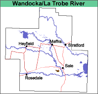 |
Original Vegetation
It is likely that this map unit was partly timbered red gum (Eucalyptus tereticornis).
Soils
See Wandocka and La Trobe map units.
Land Use
The land is mostly used for annual or irrigated pastures.
© State of Victoria (Agriculture Victoria) 1996 - .

This work, Victorian Resources Online, is licensed under a Creative Commons Attribution 4.0 licence. You are free to re-use the work under that licence, on the condition that you credit the State of Victoria (Agriculture Victoria) as author, indicate if changes were made and comply with the other licence terms.
The licence does not apply to ‘branding’ or some ‘images or photographs’ that may be owned by third parties. We ask you to seek prior approval to use images using the VRO feedback form. Access to higher quality images can also be provided on request.
This page was last updated on .