
GP31
| Location: Macalister Research Farm. | Australian Soil Classification: Vertic & Hypocalcic, Subnatric, Brown SODOSOL. |
| Great Soil Group: Solodic. | Geology: Late Pleistocene fluvial sediments. |
| General Landscape Description: Level plain. | Mapping Unit: Denison. |
| Site Description: Dairy grazing paddock. |
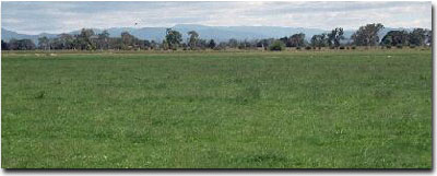 Site GP31 Landscape |
Soil Profile Morphology:
| Surface Soil | 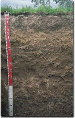 Site GP31 Profile | ||
| A1 | 0-25 cm | Dark greyish brown (10YR4/2); very fine sandy clay loam; very firm consistence dry; pH 6.0; clear change to: | |
| A2 | 25-35cm | Yellowish brown (10YR5/4) conspicuously bleached; clay loam; contains a few (5%) iron nodules; pH 6.1; clear and wavy change to: | |
| Subsoil | |||
| B21 | 35-60 cm | Strong brown (7.5YR5/6) with greyish brown (7.5YR5/2) mottles; light medium clay; moderate coarse blocky, parting to moderate fine polyhedral structure; friable consistence moist; contains a few (5%) manganese nodules (2-4 mm in size); pH 7.1; gradual and wavy change to: | |
| B22 | 60-110 cm | Brown (7.5YR5/4); medium heavy clay; slickensides present; contains a few (5%) carbonate/silica nodules (up to 10 cm in size); pH 8.5: | |
| B23 | 110+ cm | Weak red (2.5YR5/4) with slight strong brown (7.5YR5/8) mottles; medium clay; moderate coarse prismatic, parting to strong coarse blocky structure; strong consistence dry; pH 9.0. | |
Key Profile Features:
- Strong texture contrast between surface (A) horizon (27% clay) and the sodic subsoil (B21) horizon (60% clay).
- Vertic properties (i.e. significant shrink-swell characteristics) in deeper subsoil.
Soil Profile Characteristics:
Horizon | pH | Salinity Rating | ||
Surface (A1 horizon) | Moderately Acid | Very Low | Non-Sodic | None1 |
Subsoil (B21 horizon) | Slightly Alkaline | Very Low - Low | Sodic | Slight2 |
Deeper subsoil (at 1 m) | Moderately Alkaline | Very Low - Low | Sodic | Complete |
2 Complete dispersion after remoulding.
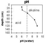 | The soil profile becomes increasingly alkaline with depth. | 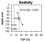 | The surface is non-sodic. The subsoil is sodic throughout. |
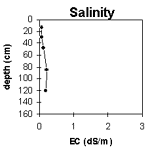 | The salinity rating is very low throughout the profile. | 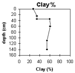 | There is a sharp increase in clay at the A/B horizon interface. |
Horizon | Horizon Depth (cm) | pH (water) | pH (CaCl2) | EC 1:5 | Exchangeable Cations | |||
Ca | Mg | K | Na | |||||
meq/100g | ||||||||
A1 | 0-25 | 6 | 5.2 | 0.06 | 3.8 | 1.5 | 0.25 | 0.26 |
A2 | 25-35 | 6.1 | 5.2 | 0.08 | 2 | 2 | 0.38 | 0.36 |
B21 | 35-60 | 7.1 | 6.1 | 0.11 | 2.8 | 7 | 0.44 | 1.3 |
B22 | 60-110 | 8.5 | 7.6 | 0.21 | 2.8 | 8.2 | 0.4 | 2 |
B23 | 110+ | 9 | 8 | 0.2 | 2 | 6.6 | 0.3 | 2.4 |
Horizon | Horizon Depth (cm) | Field Capacity pF2.5 | Wilting Point pF4.2 | Coarse Sand (0.2-2.0 mm) | Fine Sand (0.02-0.2 mm) | Silt (0.002-0.02 mm) | Clay (<0.002 mm) |
A1 | 0-25 | 28 | 10 | 2 | 21 | 48 | 27 |
A2 | 25-35 | 26 | 11 | 4 | 19 | 44 | 33 |
B21 | 35-60 | 33 | 19 | 3 | 9 | 28 | 60 |
B22 | 60-110 | 32 | 19 | 1 | 5 | 33 | 61 |
B23 | 110+ | 34 | 21 | 1 | 6 | 39 | 54 |
Management Considerations:
Whole Profile
- Plant Available Water Capacity (PAWC) is considered to be moderate (estimated at 85 mm) for this soil profile. This is based on an estimated effective rooting depth of 60 cm (i.e. surface soil and upper subsoil horizons). The dense and coarsely structured deeper subsoil is likely to restrict rooting depth. The upper subsoil is well structured and friable when moist so it is likely to be suitable for root growth. Most of the plant available water (i.e. 60 mm) will be in the surface (A) horizons. PAWC has been estimated using a model developed by Littleboy (1995) which uses analytical data for clay%, silt%, fine sand%, coarse sand % and wilting point.
- The surface soil is non-sodic and does not disperse. However, slight dispersion occurs after remoulding indicating that some structural degradation may occur if cultivation or overstocking occurs when the soil is wet.
- The presence of conspicuous bleaching in the subsurface (A2) horizons indicates that periodic waterlogging occurs above the slowly permeable subsoil.
- Root and water movement into the subsoil will be restricted to some degree by the sodic and slightly dispersive clay subsoil. The upper subsoil horizon is, however, reasonably well structured (parting to fine sized polyhedral shaped peds) and is fairly friable when moist. Root growth is therefore likely to be less restricted in subsoils such as this, compared to the denser and coarsely structured subsoils in the region.
- The subsoil displays vertic properties (i.e. slickensides evident) which indicates that significant shrinking and swelling occurs during wetting and drying cycles. This may disturb the roots of some plants and may have some engineering implications (e.g. disturbance to fence lines).
Profile Described By: Mark Imhof, Ian Sargeant (19/12/96).
© State of Victoria (Agriculture Victoria) 1996 - .

This work, Victorian Resources Online, is licensed under a Creative Commons Attribution 4.0 licence. You are free to re-use the work under that licence, on the condition that you credit the State of Victoria (Agriculture Victoria) as author, indicate if changes were made and comply with the other licence terms.
The licence does not apply to ‘branding’ or some ‘images or photographs’ that may be owned by third parties. We ask you to seek prior approval to use images using the VRO feedback form. Access to higher quality images can also be provided on request.
This page was last updated on .