
GP61
| Location: Rosedale. | Australian Soil Classification: Eutrophic, Subnatric, Grey SODOSOL. |
| Great Soil Group: soloth. | Geology: Pleistocene sediments. |
| General Landscape Description: Level plain (0-1% slope). | Mapping Unit: Winnindoo. |
| Site Description: Grazing paddock. | |
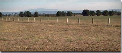 Site GP61 Landscape |
Soil Profile Morphology:
Surface Soil
| A1 | 0-5 cm | Brown (10YR4/3); loam; weak consistence moist; pH 5.1; abrupt change to: | 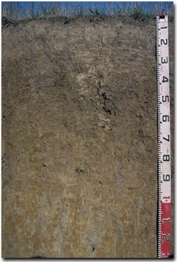 Site GP61 Profile |
| A2 | 5-20 cm | Brown (10YR5/3), conspicuously bleached (10YR6/2d) with faint yellowish brown (10YR5/8) mottles; fine sandy clay loam; weak coarse blocky structure, becoming massive; strong consistence dry; at 15-20 cm depth there are a few (2%) subangular ferromanganiferous segregations (2-6 mm in size); pH 5.0; clear and wavy change to: | |
| Subsoil | |||
| B1 | 20-40 cm | Greyish brown (10YR5/2) with yellowish brown (10YR5/8) mottles; light clay; moderate coarse prismatic, parting to moderate coarse blocky structure; very firm consistence moist; contains few (2%) quartz fragments (<2 mm in size) and a few ferromanganiferous segregations (2-6 mm in size); pH 6.1; gradual change to: | |
| B21 | 40-60 cm | Greyish brown (10YR5/2) with yellowish brown (10YR5/8) mottles; medium clay; moderate coarse prismatic, parting to moderate coarse blocky structure; strong consistence dry; contains a few (2%) quartz fragments (<2 mm in size); pH 6.4: | |
| B22 | 60-90 cm | Greyish brown (10YR5/2) with yellowish brown (10YR5/8) mottles; medium clay; moderate coarse prismatic, parting to moderate medium prismatic structure; very firm consistence moist; contains a few (2%) subangular ferromanganiferous segregations (<2 mm in size), as well as a few (2%) quartz fragments (<2 mm in size); pH 6.2: | |
| B3 | 90+ cm | Light grey (10YR7/2) with brownish yellow (10YR6/8) mottles; medium clay; weak to moderate coarse prismatic, parting to weak lenticular structure; sand lenses present; pH 5.5. | |
Key Profile Features:
- Texture contrast between surface (A) horizons and subsoil (B21) horizon.
- Bleached subsurface (A2) horizon.
Soil Profile Characteristics:
Horizon | pH | Salinity Rating | ||
Surface (A1 horizon) | Strongly Acid | Moderate | Non-Sodic | None |
Subsoil (B1 horizon) | Slightly Acid | Very Low | Sodic | Slight1 |
Deeper Subsoil (at 90 cm) | Strongly Acid | Moderate-High | Sodic | - |
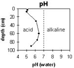 | The surface soil is strongly acid. The subsoil is slightly acid becoming strongly acid at 90 cm. | 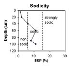 | The surface soil is non-sodic. The subsoil is sodic throughout. |
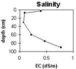 | The surface salinity rating is moderate. The subsoil is very low, becoming moderate to high at depth. | 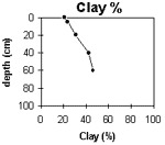 | The clay content increases gradually with depth. |
Horizon | Horizon Depth
(cm) | pH
(water) | pH
(CaCl2) | EC 1:5 | NaCl | Exchangeable Cations | |||
Ca | Mg | K | Na | ||||||
meq/100g | |||||||||
A1 | 0-5 | 5.1 | 4.6 | 0.4 | 0.06 | 6.6 | 1.9 | 1.2 | 0.1 |
A2 | 5-20 | 5 | 4.5 | 0.09 | 3.1 | 2.2 | 0.6 | 0.21 | |
B1 | 20-40 | 6.1 | 5.1 | 0.07 | 2.3 | 3.8 | 0.28 | 0.47 | |
B21 | 40-60 | 6.4 | 5.5 | 0.22 | 2.3 | 6.7 | 0.31 | 1.6 | |
B22 | 60-90 | 6.2 | 5.6 | 0.47 | 0.11 | 2.1 | 6.9 | 0.3 | 1.1 |
B3 | 90+ | 5.5 | 4.9 | 0.77 | 0.17 | 1.5 | 7.1 | 0.2 | 1.7 |
Horizon | Horizon Depth (cm) | Exchangeable Aluminium mg/kg | Exchangeable Acidity meq/100g | Field Capacity pF2.5 | Wilting Point pF4.2 | Coarse Sand (0.2-2.0 mm) | Fine Sand (0.02-0.2 mm) | Silt (0.002-0.02 mm) | Clay (<0.002 mm) |
A1 | 0-5 | <10 | 13 | 10.5 | 12 | 36 | 18 | 21 | |
A2 | 5-20 | <10 | 5.6 | 8.8 | 10 | 41 | 21 | 24 | |
B1 | 20-40 | <10 | 1.3 | 9.9 | 11 | 37 | 19 | 31 | |
B21 | 40-60 | 3.9 | 13.5 | 9 | 31 | 15 | 42 | ||
B22 | 60-90 | <10 | 3.9 | 15.4 | 7 | 28 | 16 | 46 | |
B3 | 90+ | 2 | 4.5 |
Management Considerations:
Whole Profile
- Plant Available Water Capacity (PAWC) is considered to be low. Effective rooting depth is likely to be restricted to the surface horizons. The dense and coarsely structured subsoil will significantly reduce rooting depth.
- The surface soil horizons are strongly acid. This indicates that aluminium and manganese toxicity could occur with shallow rooted species. However, the level of exchangeable aluminium measured for this pit site is quite low (<10 mg/kg) and unlikely to restrict the growth of aluminium sensitive species. Lime can be used to increase soil pH but it should be noted that a pH/aluminium test is best performed from samples taken across the paddock and bulked together. Other factors also need to be considered before lime is recommended (e.g. pasture species grown, method of application, local trial responses, soil surface structure and likely cost/benefit).
- Manganese toxicity may also occur, particularly in poorly drained situations (as waterlogging may bring manganese into solution).
- Deficiencies of molybdenum and phosphorus may occur in the strongly acid surface horizons. Increasing soil pH by lime application should enable phosphorus (from superphosphate) and molybdenum to become more available. If lime is required, and pH is increased, then the availability of major nutrients should improve.
- The level of soluble salts in the surface is moderate and may restrict the growth of salt sensitive species. These levels may be unnaturally high due to the effects of the dry season at the time of sampling (i.e. summer 1997). These levels are likely to decline following heavy rainfall and/or irrigation.
- The surface (A1) horizon has a moderate nutrient holding capacity (based on the sum of the exchangeable calcium, magnesium and potassium cations). The high levels of organic matter at this site are important for improving soil fertility, water holding capacity and enhancing surface soil structure on soils such as these, with high fine sand contents (36%).
- The presence of bleaching and faint mottling in the subsurface (A2) horizon indicates that periodic waterlogging occurs above the less permeable subsoil.
- The dense and coarsely structured subsoil (B1) horizon is sodic and has a low exchangeable calcium to magnesium ratio (< 0.6). Slight dispersion was noted. Water and root movement through this horizon is likely to be restricted.
- The presence of mottling throughout the subsoil indicates imperfect subsoil drainage.
- The level of soluble salts becomes high in the deeper subsoil. This may restrict the growth of deeper-rooted salt sensitive species.
© State of Victoria (Agriculture Victoria) 1996 - .

This work, Victorian Resources Online, is licensed under a Creative Commons Attribution 4.0 licence. You are free to re-use the work under that licence, on the condition that you credit the State of Victoria (Agriculture Victoria) as author, indicate if changes were made and comply with the other licence terms.
The licence does not apply to ‘branding’ or some ‘images or photographs’ that may be owned by third parties. We ask you to seek prior approval to use images using the VRO feedback form. Access to higher quality images can also be provided on request.
This page was last updated on .