
GP32
| Location: Loy Yang | Australian Soil Classification: Magnesic, Mottled-Mesonatric, Brown SODOSOL |
| Great Soil Group: solodic | Geology: Tertiary (Pliocene) sediments. |
| General Landscape Description: Far flood plain of Pliocene fluvial landscape (sediment derived from Baw Baws). | Mapping Unit: Loy Yang. |
| Site Description: Grazing paddock. | |
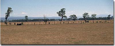 Site GP32 Landscape |
Soil Profile Morphology:
Surface Soil
| A1 | 0-20 cm | Dark brown (10YR3/3); sandy loam; weakly structured; weak consistence dry; pH 5.5; clear change to: | 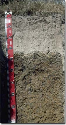 Site GP32 Soil Profile |
| A2 | 20-40 cm | Brown (10YR5/3) conspicuously bleached (10YR8/2d); sandy loam; firm consistence dry; contains a few (5-10%) iron nodules (5-10 mm in size) and a few (3%) quartz fragments (3-4 mm in size); pH 5.6; sharp and wavy change to: | |
| Subsoil | |||
| B21 | 40-75 cm | Yellowish brown (10YR5/8) with greyish brown (10YR5/2) and red (2.5YR5/8) mottles [at 45-65 cm depth, dark greyish brown (10YR4/2) stains occur on some ped faces]; heavy clay; moderate coarse prismatic, parting to moderate coarse blocky structure; very strong consistence dry; contains a few (2-5%) ferruginous nodules; pH 6.4: | |
| B22 | 75+ cm | Brownish yellow (10YR6/6) and yellowish brown (10YR5/8) with light brownish grey (2.5Y6/2) mottles; heavy clay; contains a few (2-5%) ferruginous nodules and quartz fragments; pH 6.4. | |
Key Profile Features:
- Strong texture contrast between surface (A) horizon (10% clay) and strongly sodic subsoil (B21) horizon (48% clay).
- Conspicuously bleached subsurface (A2) horizon.
Soil Profile Characteristics:
Horizon | pH | Salinity Rating | ||
Surface (A1 horizon) | strongly acid | very low | non-sodic | none |
Subsoil (B21 horizon) | slightly acid | very low | strongly sodic | moderate - strong |
Deeper subsoil (at 75+ cm) | slightly acid | very low | strongly sodic | slight 1 |
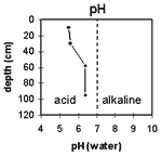 | The surface soil is strongly acid. The subsoil is slightly acid. | 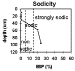 | The surface is non-sodic. The subsoil is strongly sodic throughout. |
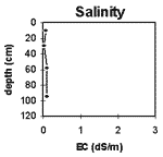 | The salinity rating is very low throughout the profile. | 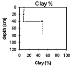 | The clay content increases significantly at the A/B horizon interface. |
Horizon | Horizon Depth (cm) | pH (water) | pH (CaCl2) | EC 1:5 | Exchangeable Cations | |||
Ca | Mg | K | Na | |||||
meq/100g | ||||||||
A1 | 0-20 | 5.5 | 4.6 | 0.06 | 2.3 | 0.62 | 0.11 | 0.14 |
A2 | 20-40 | 5.6 | 4.6 | <0.05 | 0.75 | 0.2 | <0.05 | 0.06 |
B21 | 40-75 | 6.4 | 5 | 0.09 | 0.62 | 7.8 | 0.11 | 2.1 |
B22 | 75+ | 6.4 | 5 | 0.09 | 0.13 | 7 | 0.08 | 2.2 |
Horizon | Horizon Depth (cm) | Exchangeable Aluminium mg/kg | Exchangeable Acidity meq/100g | Wilting Point pF4.2 | Coarse Sand (0.2-2.0 mm) | Fine Sand (0.02-0.2 mm) | Silt (0.002-0.02 mm) | Clay (<0.002 mm) |
A1 | 0-20 | 15 | 8.6 | 5.2 | 38 | 30 | 18 | 10 |
A2 | 20-40 | <10 | 3.6 | 2.3 | 33 | 36 | 21 | 9 |
B21 | 40-75 | 17 | 19 | 18 | 12 | 48 | ||
B22 | 75+ | 16 |
Management Considerations:
Whole Profile
- Plant Available Water Capacity (PAWC) is considered to be quite low (estimated at 50 mm) for this soil profile. This is based on an estimated effective rooting depth of 40 cm (i.e. surface soil horizons). The dense and coarsely structured upper subsoil is likely to restrict rooting depth. Most of the plant available water (i.e. 35 mm) will be in the surface (A1) horizon. PAWC has been estimated using a model developed by Littleboy (1995) which uses analytical data for clay%, silt%, fine sand%, coarse sand % and wilting point.
- The nutrient holding capacity of the sandy surface soil is low. Organic matter is important for maintaining soil fertility as well as aggregation for such soils.
- The low wilting point value (5%) of the surface (A1) horizon indicates that plants will be able to utilise very light rains when the soil is dry. However, due to the low water storage capacity, plants will soon suffer moisture stress unless further rain fall occurs.
- Strongly acid soils can have high aluminium and manganese levels which may be toxic to plants. Laboratory tests at this site show that the aluminium level of 15 ppm is quite low but this may or may not be representative of the whole paddock. A pH/aluminium test is best performed on samples taken from across the paddock and bulked together. Other factors also need to be considered before lime is recommended (e.g. pasture species grown, method of application, local trial responses, soil surface structure and likely cost/benefit).
- The presence of conspicuous bleaching in the subsurface (A2) horizon indicates that periodic waterlogging occurs above the slowly permeable subsoil. This horizon when waterlogged is likely to become ‘spewy’.
- The dense and coarsely structured upper subsoil is strongly sodic. Moderate to strong dispersion occurs in water. Root and water movement is likely to be restricted due to these conditions. The use of gypsum, in association with deep ripping, has been advocated by some researchers as an effective way to ameliorate sodic subsoils but this may not be an economic option. Deep ripping should not be carried out when the soil is in a moist to wet condition.
- The subsoil has high levels of exchangeable magnesium relative to calcium (i.e. it is magnesic). This may result in nutrient imbalances (e.g. calcium deficiency) occurring.
- The subsoil is strongly mottled throughout which indicates that subsoil drainage is imperfect.
© State of Victoria (Agriculture Victoria) 1996 - .

This work, Victorian Resources Online, is licensed under a Creative Commons Attribution 4.0 licence. You are free to re-use the work under that licence, on the condition that you credit the State of Victoria (Agriculture Victoria) as author, indicate if changes were made and comply with the other licence terms.
The licence does not apply to ‘branding’ or some ‘images or photographs’ that may be owned by third parties. We ask you to seek prior approval to use images using the VRO feedback form. Access to higher quality images can also be provided on request.
This page was last updated on .