
GP76
| Location: Boisdale. | Australian Soil Classification: Melanic, Eutrophic, Black DERMOSOL. |
| Geology: Holocene floodplain deposits. | General Landscape Description: Floodplain of Avon River. |
| Mapping Unit: Clydebank: Thomson. | Site Description: Dairy grazing paddock. |
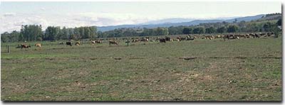 Site GP76 Landscape |
Soil Profile Morphology:
Surface Soil
| A1 | 0-30 cm | Very dark brown (10YR2/2); fine sandy clay loam; moderate coarse blocky, parting to strong fine polyhedral structure; strong consistence dry; pH 5.9; gradual change to: | 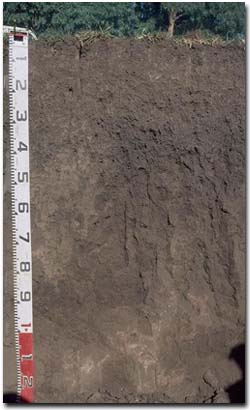 Site GP76 Profile |
| Subsoil | |||
| B21 | 30-50 cm | Black (10YR2/1); fine sandy clay loam; weak coarse prismatic, parting to strong fine polyhedral structure; pH 6.3: | |
| B22 | 50-90 cm | Dark brown (7.5YR3/2); fine sandy clay loam; moderate coarse prismatic structure; pores evident; pH 6.8: | |
| B23 | 90+ cm | Brown (7.5YR4/2); fine sandy clay loam; weakly structured; pH 7.1. | |
Key Profile Features:
- Uniform clay content throughout soil profile.
- Well structured upper profile (parting to fine polyhedral shaped peds).
Soil Profile Characteristics:
Horizon | pH | Salinity Rating | ||
Surface (A1 horizon) | Moderately Acid | Low | Non-Sodic | - |
Subsoil (B21 horizon) | Slightly Acid | Very Low | Non-Sodic | None1 |
Deeper Subsoil (at 90 cm) | Slightly Alkaline | Very Low | Non-Sodic | - |
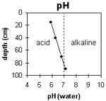 | The surface is moderately acid. The upper subsoil is slightly acid becoming slightly alkaline at 90 cm. | 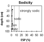 | The profile is non-sodic throughout. |
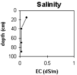 | The surface salinity rating is low. The subsoil rating is very low throughout. | 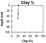 | The clay content remains constant throughout the profile. |
Horizon | Horizon Depth (cm) | pH (water) | pH (CaCl2) | EC 1:5 | ESP % | Exchangeable Cations | |||
Ca | Mg | K | Na | ||||||
meq/100g | |||||||||
A1 | 0-30 | 5.9 | 5.2 | 0.12 | 10 | 2.9 | 0.94 | 0.22 | |
B21 | 30-50 | 6.3 | 5.3 | <0.05 | 10 | 2.8 | 0.31 | 0.2 | |
B22 | 50-90 | 6.8 | 5.7 | <0.05 | 10 | 3.2 | 0.17 | 0.21 | |
B23 | 90+ | 7.1 | 6 | <0.05 | 7.3 | 4.3 | 0.08 | 0.24 | |
Horizon | Horizon Depth (cm) | Exchangeable Aluminium mg/kg | Exchangeable Acidity meq/100g | Wilting Point pF2.5 | Wilting Point pF4.2 | Coarse Sand (0.2-2.0 mm) | Fine Sand (0.02-0.2 mm) | Silt (0.002-0.02 mm) | Clay (<0.002 mm) |
A1 | 0-30 | 14.4 | 4 | 44 | 24 | 21 | |||
B21 | 30-50 | <10 | 8.6 | 10.3 | 2 | 51 | 23 | 20 | |
B22 | 50-90 | 9.5 | 2 | 52 | 22 | 19 | |||
B23 | 90+ |
Management Considerations:
Whole Profile
- Plant Available Water Capacity (PAWC) is considered to be moderate (estimated at 105 mm) for this soil profile. This is based on an estimated effective rooting depth of 50 cm (i.e. surface soil and upper subsoil). The denser and more coarsely structured deeper subsoil is likely to restrict rooting depth, although not to the same extent as some of the more sodic subsoils in the region. Much of the plant available water (i.e. 70 mm) will be in the surface (A1) horizon. PAWC has been estimated using a model developed by Littleboy (1995) which uses analytical data for clay%, silt%, fine sand%, coarse sand % and wilting point
- Infiltration of water will be rapid throughout the upper soil profile due to the well developed structure and pore space available
- The relatively deep surface soil is well structured (parting to many fine polyhedral shaped peds) and has a weak consistence. As a result, very good seed-bed conditions are provided
- Infiltration of water into the well structured surface soil will be quite high. This horizon will also be well drained
- The nutrient holding capacity of the surface (A1) horizon is moderate (based on the sum of the exchangeable cations). Organic matter is important in soils such as these with high fine sand contents for enhancing soil fertility, water holding capacity and aggregation. Nitrogen levels are also high reflecting the high organic matter levels
- The upper subsoil soil is also well structured (parting to many fine polyhedral shaped peds) and will provide a good environment for roots and relatively rapid water movement
- The deeper subsoil becomes more coarsely structured and will be more restrictive to root movement
- Black soil dries out more than red soil and becomes cloddier
- Floods every 20 years or so.
© State of Victoria (Agriculture Victoria) 1996 - .

This work, Victorian Resources Online, is licensed under a Creative Commons Attribution 4.0 licence. You are free to re-use the work under that licence, on the condition that you credit the State of Victoria (Agriculture Victoria) as author, indicate if changes were made and comply with the other licence terms.
The licence does not apply to ‘branding’ or some ‘images or photographs’ that may be owned by third parties. We ask you to seek prior approval to use images using the VRO feedback form. Access to higher quality images can also be provided on request.
This page was last updated on .