
Seaton (Se)
|
Geology |  |
Previous Maps and Reports
This map unit has been included in the Nerrim Land System as by Aldrick et al. (1992).
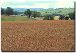 Rolling hills landscape near Lake Glenmaggie. The Seaton mapping unit occupies much of the foreground area. |
The soils in this mapping unit have not been well examined. The surface soils are characteristically dark brown to black clay loams to light medium clays which can have fragments of decomposing basalt. The subsoils are dark brown to reddish brown to black clay loams to light medium clays with increasing amounts of basalt. The soils are most likely to be classified as Ferrosols (often stony) using the Australian Soil Classification. One soil profile examined was soil pit Site GP84 and has been classified as a Red Dermosol - as the subsoil free iron oxide level of 4% is not quite high enough to be classified as a Ferrosol (needing to be 5%). |
Chemical and Physical Analysis No analyses have been carried out on the soils here. Land Use Grazing is the dominant land use. However, the soils can be suited to cropping where they are not too stony and where slopes are not too steep. | 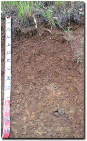 Red Ferrosol near Seaton. |
© State of Victoria (Agriculture Victoria) 1996 - .

This work, Victorian Resources Online, is licensed under a Creative Commons Attribution 4.0 licence. You are free to re-use the work under that licence, on the condition that you credit the State of Victoria (Agriculture Victoria) as author, indicate if changes were made and comply with the other licence terms.
The licence does not apply to ‘branding’ or some ‘images or photographs’ that may be owned by third parties. We ask you to seek prior approval to use images using the VRO feedback form. Access to higher quality images can also be provided on request.
This page was last updated on .