
Avon (Av)
|
Geology |
 |
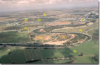 Landscape position of the Avon (Av) map unit, west of Stratford. The sediments are contemporary stream deposits. This map unit is considered to be more frequently flooded than the adjoining Thomson (Th) mapping unit. |
|
Original Vegetation
The original vegetation has been described as riverine scrub and swamps (Lunt, 1997). Aerial photographs taken in 1935 show a few remnant red gums (Eucalyptus tereticornis) but most of the map unit appears to be treeless.
Previous Maps and Reports
Skene and Walbran (1949) provided a detailed map of some of the area. Aldrick et al. (1992) mapped some of the area as Maffra 1 Land System (which includes the Thomson and Newry map units of this report) and some areas of coarser alluvium as Stratford (see Recent Coarse River Sediments mapping unit). Ward (1977) mapped the area as Wuk Wuk which also includes the Thomson and Newry mapping units in this report.
Soils
Skene and Walbran (1949) mapped three types of soils within this map unit and they referred to them as the Avon Suite: Type 1, Type 2 and Type 3. They describe the soils as yellowish alluvium from the Avon River deposited over grey clay. This grey clay represents an earlier soil profile and is referred to in this current report as Thomson mapping unit
The surface soils of the Avon Suite are described as yellowish grey-brown fine sands (Type 1), silty loams (Type 2) and silty clay loams (Type 3). The subsoils range from sands to clay loams. Below 1 metre depth, dark grey silty clays are usually encountered. The silty clay loam surface soils (Type 3) are generally found along the lower reaches of the Avon River flood plain and are underlain by sands at about 75 cm.
Chemical and Physical Analysis
No soil pits have been dug on this maping unit. However, Skene and Walbran (1949) provided analyses for three soils and can be viewed below.
The surface pH’s of the soils are between 5.5 and 6.5, with variable pH’s in the subsoil. The subsoils of Type 3 which occur along the lower reaches of the Avon River flood plain, were quite saline. No exchangeable cation data is available.
Avon Suite Type 1, (Skene and Walbran, 1949)
Depth cm | Texture | pH | EC dS/m | Cl % | Nitrogen % | Carbon % | Ca meq % | Mg meq % | K meq % | Na meq % | H meq % | ESP % | Gravel % | Coarse sand % | Fine sand % | Silt % | Clay % | LAT % |
0-13 | FSL | 5.8 | 0.05 | .004 | 0.14 | 1.72 | 7 | 67 | 12 | 8 | <1 | |||||||
13-46 | FSL | 6.1 | 0.05 | .005 | 1 | 74 | 12 | 8 | <1 | |||||||||
99-117 | S | 5.6 | 0.16 | .013 | 7 | 76 | 7 | 6 | <1 | |||||||||
142-198 | FS | 5.7 | 0.13 | .008 | 1 | 79 | 9 | 8 | 1 | |||||||||
223-259 | ZCL | 5.4 | 0.21 | .019 | 1 | 20 | 43 | 29 | 1 |
Avon Suite Type 2, (Skene and Walbran, 1949)
Depth cm | Texture | pH | EC dS/m | Cl % | Nitrogen % | Carbon % | Ca meq % | Mg meq % | K meq % | Na meq % | H meq % | ESP % | Gravel % | Coarse sand % | Fine sand % | Silt % | Clay % | LAT % |
0-18 | FSL | 5.8 | 0.05 | .004 | 0.132 | 1.50 | 4 | 68 | 14 | 9 | 1 | |||||||
38-53 | FSL | 6.4 | 0.06 | .006 | <1 | 76 | 13 | 7 | 1 | |||||||||
84-122 | FSCL | 5.5 | 0.30 | .041 | 1 | 54 | 27 | 12 | 1 | |||||||||
132-160 | ZCL | 5.8 | 0.57 | .081 | 4 | 17 | 44 | 30 | 1 | |||||||||
173-213 | ZMC | 8.1 | 0.44 | .059 | 4 | 17 | 35 | 41 | 1 |
Avon Suite Type 3, (Skene and Walbran, 1949)
Depth cm | Texture | pH | EC dS/m | Cl % | Nitrogen % | Carbon % | Ca meq % | Mg meq % | K meq % | Na meq % | H meq % | ESP % | Gravel % | Coarse sand % | Fine sand % | Silt % | Clay % | LAT % |
0-13 | ZL | 5.7 | 0.63 | .070 | 0.199 | 2.76 | <1 | 23 | 48 | 20 | 1 | |||||||
13-30 | ZL | 4.8 | 2.09 | .264 | 2 | 15 | 41 | 31 | 2 | |||||||||
30-41 | ZCL | 4.3 | 2.30 | .336 | 5 | 14 | 37 | 36 | 3 | |||||||||
41-71 | ZLC | 4.3 | 1.47 | .236 | 2 | 9 | 36 | 49 | 1 | |||||||||
81-107 | S | 4.1 | 0.24 | .024 | 66 | 23 | 6 | 5 | <1 |
The following abbreviations are used to describe field texture: S - sand; LS - loamy sand; ClS - clayey sand; SL - sandy loam; L - loam; CL - clay loam; SCL - sandy clay loam; SC - sandy clay; FSCL - fine sandy clay loam; FSC - fine sandy clay; LC - light clay; MC - medium clay; HC - heavy clay; GR - gravel; ZL - silty loam; ZCL - silty clay loam; ZLC - silty light clay; ZMC - silty medium clay.
Particle size distribution data given for Skene and Walbran (1948, 1949) does not include the water content of the soil. As a result the coarse sand, fine sand, silt, clay and loss on acid treatment (LAT) may not add up to 100%.
Other symbols include: pH - analysed in water; EC - electrical conductivity; Cl - chloride; Ca - exchangeable calcium; Mg - exchangeable magnesium, K - exchangeable potassium; Na - exchangeable sodium; H - exchangeable hydrogen; ESP - exchangeable sodium percentage.
Land Use
"Exclusive of saline situations, this association comprises soils more or less suitable for irrigation. Type 2 of the Avon Suite is an attractive soil for general irrigation, but Type 1 is very light in texture – particularly when in close proximity to the river – and is unattractive on this account. Type 3 is too saline for development under irrigation. Flooding of all three soil types is a hazard and Type 1 is typically hummocky due to turbulent water action on the light surface.” (Skene and Walbran, 1949).
Flood Risk
Probably 1 in 5 years.
© State of Victoria (Agriculture Victoria) 1996 - .

This work, Victorian Resources Online, is licensed under a Creative Commons Attribution 4.0 licence. You are free to re-use the work under that licence, on the condition that you credit the State of Victoria (Agriculture Victoria) as author, indicate if changes were made and comply with the other licence terms.
The licence does not apply to ‘branding’ or some ‘images or photographs’ that may be owned by third parties. We ask you to seek prior approval to use images using the VRO feedback form. Access to higher quality images can also be provided on request.
This page was last updated on .