
GP83
| Location: Fernbank | Australian Soil Classification: Vertic (& Magnesic), Mottled-Subnatric, Brown SODOSOL (medium to thick sandy surface horizons) |
| Great Soil Group: solodised solonetz | General Landscape Description: Undulating plain with low rises. |
| Site Description: Grazing paddock. | Geology: Quaternary (Pleistocene) sediments. |
| Mapping Unit: Fernbank | |
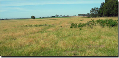 Site GP83 Landscape |
Soil Profile Morphology:
Surface Soil
| A1 | 0-15 cm | Dark brown (10YR3/3); loamy sand; pH 4.9; clear change to: | 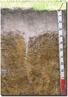 Site GP83 Profile |
| A2 | 15-30 cm | Light yellowish brown (10YR6/4) conspicuously bleached (10YR8/1 dry) mottles; sand; pH 5.1; sharp change to: | |
| Subsoil | |||
| B21 | 30-60 cm | Yellowish brown (10YR5/6) with brownish yellow (10YR6/8) and greyish brown (10YR5/2) mottles; medium heavy clay; strong very coarse columnar, parting to weak-moderate very coarse blocky and weak coarse polyhedral structure; strong consistence (dry); pH 6.3; gradual change to: | |
| B22 | 60-100 cm | Brownish yellow (10YR6/6, 6/8); light medium clay (sandy); strong very coarse prismatic structure; isolated rounded quartz gravel (5 cm); isolated slickensides; pH 7.0; gradual change to: | |
| B23 | 100-120+ cm | Yellowish brown (10YR5/6); medium clay (sandy); moderate coarse prismatic, parting to moderate coarse blocky structure; dark staining evident; contains few (10%) quartz grit; pH 7.3. | |
Key Profile Features:
- Strong texture contrast between sandy surface (A) horizons and clayey subsoil (B21) horizon.
- Conspicuously bleached subsurface (A2) horizon.
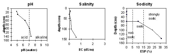
Soil Profile Characteristics:
Horizon | pH | Salinity Rating | ||
Surface (A1 horizon) | Very Strongly Acid | Very Low | Non-Sodic | None |
Subsoil (B21 horizon) | Slightly Acid | Low | Sodic | Strong |
Deeper subsoil (at 100-120+ cm) | Slightly Alkaline | Medium | Strongly Sodic | Slight - Moderate |
 |
 |
Horizon | Horizon Depth (cm) | pH (water) | pH (CaCl2) | EC 1:5 | Exchangeable Aluminium mg/kg | Exchangeable Cations | |||
Ca | Mg | K | Na | ||||||
meq/100g | |||||||||
A1 | 0-15 | 4.9 | 4.3 | 0.08 | 26 | 1.5 | 0.41 | 0.07 | 0.28 |
A2 | 15-30 | 5.1 | 4.5 | <0.05 | 13 | 0.35 | 0.10 | <0.05 | 0.21 |
B21 | 30-60 | 6.3 | 5.2 | 0.11 | 12 | 2.1 | 6.1 | 0.14 | 1.7 |
B22 | 60-100 | 7.0 | 6.1 | 0.16 | 0.98 | 7.3 | 0.13 | 2.6 | |
B23 | 100-120+ | 7.3 | 6.7 | 0.58 | 0.7 | 7.3 | 0.1 | 3.7 | |
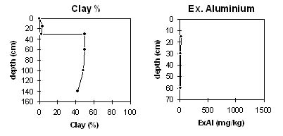
Horizon | Horizon Depth (cm) | Exchangeable Acidity meq/100g | Field Capacity pF2.5 | Wilting Point pF4.2 | Coarse Sand (0.2-2.0 mm) | Fine Sand (0.02-0.2 mm) | Silt (0.002-0.02 mm) | Clay (<0.002 mm) | Bulk Density Kg/L |
A1 | 0-15 | 7.7 | 11 | 4 | 50 | 32 | 9 | 4 | |
A2 | 15-30 | 1.1 | 7 | 1 | 50 | 37 | 8 | 2 | 1.5 |
B21 | 30-60 | 7.4 | 29 | 18 | 23 | 18 | 8 | 50 | 1.6 |
B22 | 60-100 | 28 | 24 | 21 | 9 | 48 | |||
B23 | 100-120+ | 17 | 15 | 9 | 30 | 18 | 42 |
Management Considerations:
Surface (A) Horizons
- The sandy surface horizons have a low water storage capacity. The low wilting point values indicate that plants will be able to utilise light rains falling on relatively dry soils. However, due to the low water storage capacity, plants will soon suffer moisture stress unless further rainfall occurs. Organic matter is important in these sandy soils to enhance water holding capacity – as well as to enhance aggregation as well as fertility. These sandy soils have a low inherent fertility and are very strongly acid. Such strongly leached soils are also likely to be naturally deficient in nitrogen, phosphorus, sulphur and potassium. Lime application will result in increased pH levels and make certain nutrients such as phosphorus more available to plants. Deficiencies of the trace element molybdenum (Mo) are also likely to occur in acid sandy soils (soil adsorption of MO increases as pH decreases, leading to reduced availability to plants).
Subsoil (B) Horizons
- The dense and coarsely structured upper subsoil is sodic and strongly dispersive. This will result in restricted root and water movement into the subsoil. After heavy rains water is likely to build up on top of the subsoil – leading to potential waterlogging in the sandy surface horizons.
© State of Victoria (Agriculture Victoria) 1996 - .

This work, Victorian Resources Online, is licensed under a Creative Commons Attribution 4.0 licence. You are free to re-use the work under that licence, on the condition that you credit the State of Victoria (Agriculture Victoria) as author, indicate if changes were made and comply with the other licence terms.
The licence does not apply to ‘branding’ or some ‘images or photographs’ that may be owned by third parties. We ask you to seek prior approval to use images using the VRO feedback form. Access to higher quality images can also be provided on request.
This page was last updated on .