
Warragul (Wg)
|
| 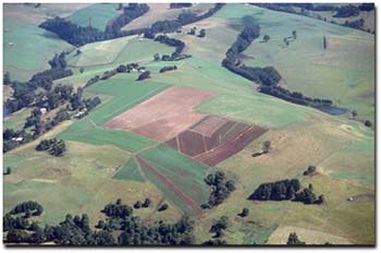 Undulating rises within the Warragul unit near Thorpdale. |
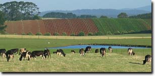 Cropping and grazing on Ferrosols near Neerim South. | 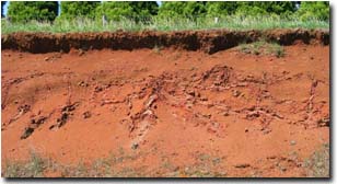 Ferrosol near Leongatha |
Soils
Component 1
About half the soils have a dark reddish brown or dark brown very friable clay loam surface grading into red or brownish red crumbly clay loam or light clay at about 20 to 40 cm. Textures generally increase to medium clay at about 1 m. In the deeper subsoil (between 1 m and 1.8 m) the soil may remain red, or be mottled red, brown and brownish yellow (see Soil Site SG13 and Site GP15 for examples of Acidic Red Ferrosols within this unit).
Component 2
At about 20 to 40 cm depth, about one third of the soils have dark greyish brown friable clay loam surface soils passing to yellowish brown light clay or clay loams. By about 50 cm the texture increases to medium clay. Brownish red mottling generally occurs with depth. The soil remains crumbly throughout the profile.
Component 3
Yellow friable soils occur in areas of slightly impeded drainage such as saddles and gentle slopes. The surface soils are dark greyish brown friable clay loams, grading into yellowish brown light or medium clays at about 20 cm. Generally from about 70 cm, the soils become mottled yellowish brown, brownish yellow and brownish red. The soils are more clayey and sticky than the redder and browner soils described above. They are classified as Yellow Ferrosols.
Note: It is likely that some areas which are described as Components 2 and 3 are not as crumbly as described above and would better match the description of soils within the Silver Creek mapping unit. Soils that are weakly structured (i.e. more 'earthy' than the above described soils) and contain less free iron oxide, are likely to be classified as Kandosols.
Warragul with Neerim South (Wg/Ns)
This mapping unit describes areas which comprise mostly the Warragul mapping unit with some areas of the Neerim South mapping unit. The percentage of the dominant mapping unit, Warragul, is at least 70%.
Warragul with Allambie (Wg/Ab)
This mapping unit describes areas comprising mostly the Warragul mapping unit with some areas of the Allambie mapping unit. The percentage of the dominant mapping unit is at least 70%. Areas within this mapping unit are prone to landslips, particularly where the Allambie geological formation outcrops around the margins of the Tertiary Older Volcanics (Brumley, 1983).
Warragul with Silver Creek (Wg/Sc)
This mapping unit describes areas comprising mostly the Warragul mapping unit with some areas of the Neerim South mapping unit. The percentage of the dominant mapping unit is at least 70%.
Warragul with Silver Creek with Allambie (Wg/Sc/Ab)
This mapping unit describes areas comprising about half the Warragul mapping unit with some areas of the Silver Creek and Allambie mapping units. The percentage of the dominant mapping unit (Warragul) is at least 50%. The areas of the Silver Creek and the Allambie mapping unit are about 25% or less.
© State of Victoria (Agriculture Victoria) 1996 - .

This work, Victorian Resources Online, is licensed under a Creative Commons Attribution 4.0 licence. You are free to re-use the work under that licence, on the condition that you credit the State of Victoria (Agriculture Victoria) as author, indicate if changes were made and comply with the other licence terms.
The licence does not apply to ‘branding’ or some ‘images or photographs’ that may be owned by third parties. We ask you to seek prior approval to use images using the VRO feedback form. Access to higher quality images can also be provided on request.
This page was last updated on .