
Talbotville (Te)
 |
Geology
This map unit occurs on the extensive Palaeozoic sediments throughout the Eastern Victorian Uplands. Geology includes shales, siltstones, sandstones, occasionally metamorphosed.
Landform
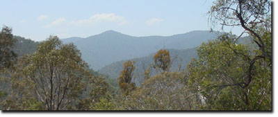
The mountainous terrain ridge and ravine topography has long steep slopes and rock
outcrops are abundant.
Landuse
Mostly uncleared. There is insufficient land which is cleared to make comments on land management issues.
Previous Maps and Reports
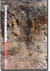
One soil profile (profile No. 11) - (PDF 90KB) was examined by Aldrick et al. (1992). Bedrock (decomposing siltstone and shale) was encountered 22 cm from the surface and about 30% of the soil was comprised of rock fragments up to 20 mm in diameter. The surface soil was a dark brown gravely clay loam overlying a strong brown gravely clay loam with increasing quantities of rock fragments. The pH was about 5.0 throughout. The soils were non-sodic.
Depth (cm) | pH | CEC (meq/100g) | Sodicity (ESP) |
0-5 | 4.8 – very strongly acid | 31.4 – high | 1 - non-sodic |
5-10 | 5.0 – very strongly acid | 21.6 – moderate | 1 - non-sodic |
10-20 | 5.0 - very strongly acid | 22.1 – moderate | 1 - non-sodic |
Soils
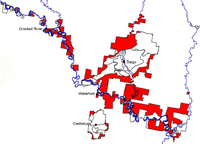 | The red shading shows the extent of the Talbotville map unit (Sargeant and Sargant, 2005). |
Talbotville Map Unit profile
© State of Victoria (Agriculture Victoria) 1996 - .

This work, Victorian Resources Online, is licensed under a Creative Commons Attribution 4.0 licence. You are free to re-use the work under that licence, on the condition that you credit the State of Victoria (Agriculture Victoria) as author, indicate if changes were made and comply with the other licence terms.
The licence does not apply to ‘branding’ or some ‘images or photographs’ that may be owned by third parties. We ask you to seek prior approval to use images using the VRO feedback form. Access to higher quality images can also be provided on request.
This page was last updated on .