
SG2
|
Location: Inverloch | Australian Soil Classification: Humose-Bleached, Magnesic, Grey KUROSOL |
| Northcote Factual Key: Dy 3.41 | Great Soil Group: soloth |
| Geology: Tertiary fluviatile sediments. Quartz in profile may be related to "Haunted Hills gravels". | General Landscape Description: Midslope of a rise (5% slope). |
| Soil Mapping Unit: Inverloch. | Site Description: Forest Reserve near Inverloch. |
| Native Vegetation: Messmate (Eucalyptus obliqua), Narrow-leaved Peppermint (E. radiata) Gippsland Mallee (E. kitsoniana). | |
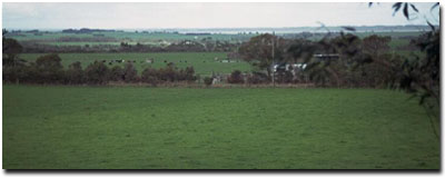 Site SG2 Landscape |
Soil Profile Morphology:
Surface Soil
| A1 | 0-20 cm | Black (10YR2/1); sandy loam; firm surface condition; very weak coarse blocky structure; firm consistence dry; contains a few (5-10%) fine quartz gravels (2-4 mm size); pH 4.7; abrupt change to: | 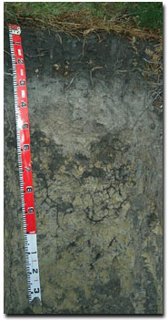 Site SG2 Profile |
| A21 | 20-40 cm | Grey (10YR5/1) conspicuously bleached (10YR7/1d); light sandy loam; massive; firm consistence dry; contains a few (5-10%) fine quartz gravels (2-4 mm size); pH 4.7; clear change to: | |
| A22 | 40-55 cm | Greyish brown (10YR5/2) conspicuously bleached; light sandy loam; massive; strong consistence dry; contains many (20%) quartz gravel (2-10 mm size); pH 4.6; sharp and wavy change to: | |
| Subsoil | |||
| B21 | 55-100 cm | Light brownish grey (10YR6/2) with brownish yellow (10YR6/8) mottles; medium heavy clay; strong very coarse blocky, parting to strong coarse blocky structure (with significant dark staining on ped faces); very strong consistence dry; pH 4.8; gradual change to: | |
| B22 | 100+ cm | Similar to above horizon but with reduced dark staining on ped faces; pH 4.8. | |
Key Profile Features:
- Humus rich surface horizon.
- Strong texture contrast between sandy loam surface (A) horizons and medium heavy clay subsoil (B) horizons.
- Conspicuously bleached A2 horizons.
Soil Profile Characteristics:
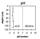 | 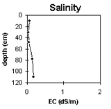 | 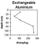 | 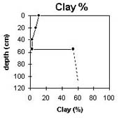 |
The soil profile is very strongly acid throughout. | The salinity rating is very low throughout the profile. | Significant levels of exchangeable aluminium are present in the subsoil (B) horizons. | The clay % increases sharply at the A/B horizon boundary. |
Horizon | Horizon Depth (cm) | pH water | pH CaCl2 | EC 1:5 | Exchangeable Cations | Ex. Al mg/kg | Ex. Acidity meq/100g | Wilting Point pF 4.2 | Coarse Sand (0.2 -2 mm) | Fine Sand (0.02-0.2 mm) | Silt (0.002-0.02 mm) | Clay (<0.002 mm) | |||
Ca | Mg | K | Na | ||||||||||||
meq/100g | |||||||||||||||
A1 | 0-20 | 4.7 | 3.6 | 0.06 | 2.8 | 2.3 | 0.3 | 0.2 | 110 | 23.6 | 14 | 22 | 35 | 20 | 11 |
A21 | 20-40 | 4.7 | 3.5 | <0.05 | 0.3 | 0.2 | 0.1 | 0.1 | 45 | 4.4 | 2 | 23 | 46 | 25 | 7 |
A22 | 40-55 | 4.6 | 3.7 | 0.05 | 0.3 | 0.3 | 0.1 | <0.1 | 110 | 4 | 3.2 | 26 | 39 | 34 | 2 |
B21 | 55-100 | 4.8 | 3.9 | 0.14 | 0.2 | 4.0 | 0.3 | 0.5 | 250 | 24.2 | 22.4 | 8 | 19 | 15 | 54 |
B22 | 100+ | 4.8 | 3.9 | 0.17 | 0.2 | 6.1 | 0.3 | 0.9 | 260 | 17.4 | |||||
Management Considerations:
Whole Profile
- Plant Available Water Capacity (PAWC) is considered to be very low - low (estimated at approximately 50 mm). This is based on available laboratory data and assumes an effective rooting depth of 60 cm.
- The surface horizon has a high organic matter content which reflects this site being under native vegetation.
- The surface soil is very strongly acidic which indicates that aluminium toxicity may occur. The exchangeable aluminium level measured in the laboratory (110 mg/kg) is high enough to affect aluminium sensitive species (e.g. phalaris and medics). A pH/aluminium test (sampled over the whole paddock) may be appropriate to determine the amount of lime needed to raise pH. Other factors need to be considered before lime is recommended e.g pasture species grown, method of application, local trial responses, soil surface structure and likely cost/benefit.
- The inherent fertility (based on the sum of the exchangeable basic cations) is low for the surface horizon and very low for the bleached A2 horizons.
- Deficiencies in molybdenum, phosphorus and potassium may occur in the very strongly acid surface soil. Lime application may assist in increasing phosphorus availability. Plant tissue analysis may give a more accurate assessment of molybdenum requirements.
- The surface soil has a slight amount of quartz gravel which will result in abrasive damage to farm implements.
- The subsurface (A22) horizon becomes "runny" or "spewy" when wet and sets very hard when dry.
- Infiltration of rainfall is likely to be high for the surface soil.
- Exchangeable aluminium levels are high in the subsoil which is likely to affect sensitive species (e.g. cocksfoot, ryegrass, subclover, white clover).
- The subsoil is strongly magnesic (80%) which may result in poor physical and chemical conditions for plant growth. The subsoil is very coarsely structured and root and water movement will be restricted. As a consequence, after heavy rains water will build up on top of the relatively impermeable subsoil and waterlogging will occur. The presence of a conspicuously bleached A2 horizon above the subsoil indicates that periodic waterlogging does occur. On slopes, lateral movement of water may occur along the top of the subsoil.
- Nutrient imbalances (e.g. calcium deficiency) could also occur in the magnesic subsoil.
Profile Described By: Mark Imhof, Ian Sargeant and Sonia Thompson (20/6/95).
© State of Victoria (Agriculture Victoria) 1996 - .

This work, Victorian Resources Online, is licensed under a Creative Commons Attribution 4.0 licence. You are free to re-use the work under that licence, on the condition that you credit the State of Victoria (Agriculture Victoria) as author, indicate if changes were made and comply with the other licence terms.
The licence does not apply to ‘branding’ or some ‘images or photographs’ that may be owned by third parties. We ask you to seek prior approval to use images using the VRO feedback form. Access to higher quality images can also be provided on request.
This page was last updated on .