
Heath Mounds (Hm)
Note: This unit was previously called sand plain.
| Geology Recent to Pleistocene aeolian and alluvial sediments that were reworked by wind in a past glacial period (approximately 20,000 years ago). Landform Dunefield and sand plain. The mapping unit comprises low dunes (60%), almost level sandy plains (25%) and broad clayey swales (15%). |  |
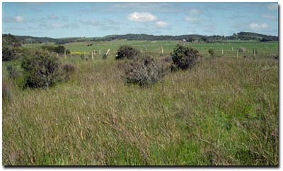
Heath Mound unit near Bald Hills. Note swampy vegetation in foreground and
sand dunes in background.
Soils
Component 1
Most of the soils have a dark grey, loamy sand surface soil. A pronounced bleached zone occurs near 30 cm. At about 90 cm a "coffee rock" layer is encountered. This layer comprises black, dark brown and yellowish brown cemented sands and is frequently impenetrable to the soil auger. Below the "coffee rock", light yellowish-brown or brownish-yellow sands generally occur, although in lower lying areas mottled clays or sandy clays may occur. The soils are identical to most of the soils within the Nyora mapping unit.
In the broad zone where the sand plain adjoins the coastal dune the bleached layer is often absent and pale sands are found below the immediate surface soil. A weakly developed cemented layer is generally present at about 90 cm. Soil Site SG10 is an example of an Aeric Podosol within this unit.
Component 2
Most of the soils have a dark grey surface sandy loam to sandy clay loam surface soil. A bleached zone of similar texture generally occurs near 30 cm. A layer of "coffee rock" or humus enriched material frequently occurs below the bleached layer. Mottled light brownish grey with yellowish brown sandy clay loams grading into sandy clays occur from about 60 to 80 cm. Soil Site SG9 is an example of an Aquic Podosol within this mapping unit.
Component 3
Most of the surface soils of this component are dark grey to black light to medium clays (frequently sandy) which tend to crack on drying. These grade into grey or brownish-grey medium clays with fine brown mottling. Grey and brown mottled clays continue to at least 1 m depth. Soil Site SG4 is an example of an Aquic Vertosol that occasionally occurs within this mapping unit and more frequently within the Tarwin unit. The soils are essentially the same as those described for the Tarwin mapping unit.
© State of Victoria (Agriculture Victoria) 1996 - .

This work, Victorian Resources Online, is licensed under a Creative Commons Attribution 4.0 licence. You are free to re-use the work under that licence, on the condition that you credit the State of Victoria (Agriculture Victoria) as author, indicate if changes were made and comply with the other licence terms.
The licence does not apply to ‘branding’ or some ‘images or photographs’ that may be owned by third parties. We ask you to seek prior approval to use images using the VRO feedback form. Access to higher quality images can also be provided on request.
This page was last updated on .