
GP49
| Location: Giffard West | Australian Soil Classification: Mottled, Subnatric, Brown SODOSOL |
| Geology: Late Tertiary deposits (later modified by wind). | General Landscape Description: Level plain (Giffard Plain). |
| Soil Mapping Unit: Giffard | Site Description: Grazing paddock. |
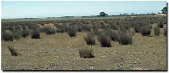 Site GP49 Landscape |
Soil Profile Morphology:
Surface Soil
| A11 | 0-12 cm | Dark greyish brown (10YR4/2); light sandy loam (organic); weak structure; very weak consistence dry; contains few (5%) subrounded quartz fragments (2-6 mm in size); pH 5.0; gradual change to: | 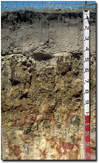 Site GP49 Profile |
| A12 | 12-25 cm | Loamy sand; firm consistence dry; contains few (5-10%) subrounded quartz fragments (2-6 mm in size); gradual change to: | |
| A2 | 25-40 cm | Pale brown (10YR6/3) conspicuously bleached (10YR8/2d); loamy sand; weak consistence dry; pH 6.1; sharp and wavy change to: | |
| Subsoil | |||
| B21 | 40-80 cm | Yellowish brown (10YR5/6) and brownish yellow (10YR6/8), with pale brown (10YR6/3) and strong dark grey (10YR4/1) mottles; heavy clay; moderate coarse columnar structure; strong consistence dry; pH 6.9; gradual change to: | |
| B22 | 80-110 cm | Yellowish brown (10YR5/8) with dark red (2.5YR4/8) and light grey mottles (10YR7/1) (associated with root channels); medium heavy clay; smooth-faced peds; moderate coarse prismatic, parting to moderate coarse blocky structure; dark stains along prism faces; strong consistence dry; pH 7.9; clear and wavy change to: | |
| BC | 110-130 cm | Light grey (10YR7/1) with dark red (2.5YR4/8) and brownish yellow (10YR6/8) mottles; sandy loam (clayey); contains few (5-10%) sub-rounded quartz fragments (2-5 mm in size); pH 8.0. | |
Key Profile Features:
- Very strong texture contrast between sandy surface (A) horizons and subsoil (B) horizons.
- Accumulation of quartz fragments within the upper surface horizons.
- Conspicuously bleached sub-surface (A2) horizon.
- Coarse columnar structure in upper subsoil.
Soil Profile Characteristics:
pH | Salinity Rating | |||
Surface (A1 horizon) | Strongly Acid | Low | Non-Sodic | None |
Subsoil (B21 horizon) | Slightly Acid | Very Low | Sodic | Strong1 |
Deeper subsoil (at 1 m) | Slightly Alkaline | Low | Strongly Sodic | Complete |
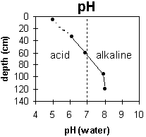 | 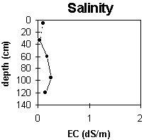 | 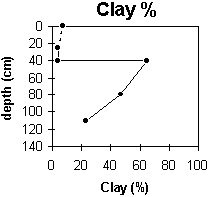 |
The surface soil is strongly acid. The upper subsoil is slightly acid becoming slightly alkaline at 60 cm. | The salinity rating is low throughout the profile. | The clay content increases markedly at the A/B boundary (i.e. 40 cm depth). |
Horizon | Horizon Depth (cm) | pH (water) | pH (CaCl2) | EC 1:5 | NaCl | Exchangeable Cations | |||
Ca | Mg | K | Na | ||||||
meq/100g | |||||||||
A1 | 0-12 | 5 | 4.3 | 0.09 | 2.2 | 0.77 | 0.15 | 0.23 | |
A12 | 12-25 | ||||||||
A2 | 25-40 | 6.1 | 5.4 | <0.05 | 0.35 | 0.29 | 0.06 | 0.08 | |
B21 | 40-80 | 6.9 | 5.8 | 0.17 | 3.1 | 6.9 | 2.1 | 1.9 | |
B22 | 80-110 | 7.9 | 6.8 | 0.26 | 0.03 | 0.95 | 5.1 | 0.24 | 3.2 |
BC | 110-130 | 8 | 6.8 | 0.15 | 0.34 | 1.9 | 0.08 | 1.3 | |
Horizon | Horizon Depth (cm) | Exchangeable Aluminium mg/kg | Exchangeable Acidity meq/100g | Field Capacity pF2.5 | Wilting Point pF4.2 | Coarse Sand (0.2-2.0 mm) | Fine Sand (0.02-0.2 mm) | Silt (0.002-0.02 mm) | Clay (<0.002 mm) |
A1 | 0-12 | 15 | 7 | 48 | 32 | 8 | 7 | ||
A12 | 12-25 | ||||||||
A2 | 25-40 | 1 | 50 | 37 | 10 | 4 | |||
B21 | 40-80 | 8.8 | 23.5 | 15 | 12 | 6 | 65 | ||
B22 | 80-110 | 3.2 | 16.8 | 33 | 15 | 6 | 47 | ||
BC | 110-130 | 57 | 19 | 2 | 23 |
Management Considerations:
Whole Profile
- Plant available water capacity (PAWC) is considered to be very low (estimated at 40 mm) for the top metre of the soil profile. This is based on available laboratory data and assumes an effective rooting depth of 40 cm. Effective rooting depth will be restricted in the dense and coarsely structured subsoil. PAWC has been estimated using a model developed by Littleboy (1995) which uses analytical data for clay %, silt %, fine sand %, coarse sand % and wilting point value.
- The surface (A11) horizon is strongly acid which indicates that aluminium toxicity may occur. However, levels of exchangeable aluminium measured at this site are not high (i.e. 15 mg/kg). A pH/aluminium test sampled across the paddock would be most appropriate to determine whether lime is needed to raise soil pH. However, other factors need to be considered before lime is recommended (e.g. pasture species grown, method of application, local trial responses, soil surface structure and likely cost/benefit).
- The inherent fertility of the surface (A1) horizon (based on the sum of the exchangeable calcium, magnesium and potassium cations) is very low. The high levels of organic matter at this site are important for maintaining soil fertility, water holding capacity and enhancing surface soil structure (especially with the high sand content of 80%).
- The sandy surface horizons (80% sand) will be quite permeable and have a low water storage capacity. The low wilting point value (i.e. 7 %) indicates that plants will be able to utilise light rains falling on dry soil. However, due to the low water storage capacity, plants will soon suffer moisture stress unless further rain occurs. Organic matter is an important source of nutrient holding capacity in sandy soils. It is also important in these sandy soils to enhance water holding capacity and fertility.
- Deficiencies of the trace element molybdenum (Mo) are likely to occur in acid sandy soils (soil adsorption of Mo increases as pH decreases, leading to reduced availability to plants). Any deficiencies can be confirmed by plant tissue analysis. Deficiencies can be remedied with molybdenum-enriched fertiliser and foliar application. Lime application on acid soils will also make molybdenum more available to plants.
- Manganese toxicity may also occur in strongly acid soils, particularly when poorly drained (as waterlogging may bring manganese into solution).
- The sub-surface (A2) horizon is extremely infertile, so building up the surface (A) soil should be a prime objective.
- The presence of conspicuous bleaching within the (A2) horizon indicates periodic waterlogging occurs above the more slowly permeable subsoil.
- The dense and coarsely structured subsoil is sodic (and has a low exchangeable calcium to magnesium ratio) becoming strongly sodic with depth. Strong dispersion occurs as a result. This indicates that water and root movement will be significantly restricted in the subsoil. Water will build up on top of the subsoil during wet periods and waterlogging may result.
- Root movement will also be restricted by the hard capping of the coarse columnar structure.
© State of Victoria (Agriculture Victoria) 1996 - .

This work, Victorian Resources Online, is licensed under a Creative Commons Attribution 4.0 licence. You are free to re-use the work under that licence, on the condition that you credit the State of Victoria (Agriculture Victoria) as author, indicate if changes were made and comply with the other licence terms.
The licence does not apply to ‘branding’ or some ‘images or photographs’ that may be owned by third parties. We ask you to seek prior approval to use images using the VRO feedback form. Access to higher quality images can also be provided on request.
This page was last updated on .