
GP44
| Location: Tarraville. | Australian Soil Classification: Vertic, Subnatric |
| Black SODOSOL. | Geology: Late Pleistocene alluvial deposits. |
| General Landscape Description: Level plain. | Soil Mapping Unit: Yarram, clay surface. |
| Site Description: Irrigated grazing paddock. | |
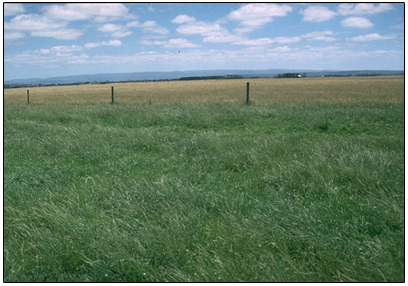 GP44 Landscape |
Soil Profile Morphology:
Surface Soil
| A11 | 0-5 cm | Black (10YR2/1); hard surface condition; light fine sandy clay loam; strong medium polyhedral, parting to fine polyhedral structure; very firm consistence dry; pH 6.0; clear change to: | 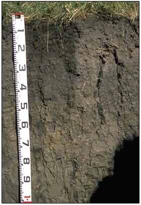 Site GP44 profile |
| A12 | 5-20 cm | Black (10YR2/1); light fine sandy clay loam; strong medium prismatic, parting to strong fine prismatic structure; very firm consistence dry; pH 5.8; slightly wavy change to: | |
| Subsoil | |||
| B21 | 20-40 cm | Black (10YR2/1) with faint brownish yellow (10YR6/6) mottles; medium clay; moderate coarse prismatic, parting to moderate coarse angular blocky structure; very strong consistence dry; pH 6.2; clear change to: | |
| B22 | 40-80 cm | Dark grey (10YR4/1) with yellowish red (10YR5/6) mottles; heavy clay; moderate coarse prismatic, parting to moderate coarse angular blocky structure; very strong consistence dry; pH 7.0; gradual change to: | |
| B23 | 80-140 cm | Grey (10YR5/1) with light yellowish brown (2.5Y6/4) mottles; heavy clay; slickensides are evident with lenticular structure; pH 7.6. |
Key Profile Features:
- Strong texture contrast between surface (A) and subsoil (B) horizons.
- Strong vertic properties in subsoil (i.e. slickensides and lenticular peds).
pH | Salinity Rating | |||
Surface (A11 horizon) | Moderately Acid | Low | Non- Sodic | None |
Subsoil (B21 horizon) | Slightly Acid | Low | Sodic | Moderate1 |
Deeper subsoil (at 1 m) | Slightly Alkaline | Moderate - High | Strongly Sodic | None |
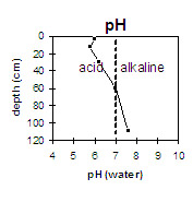 | 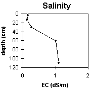 | 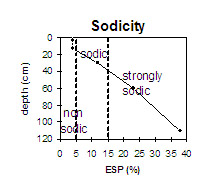 | 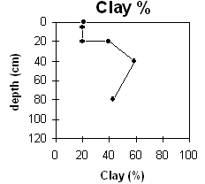 |
The surface soil is moderately acid. The upper subsoil is slightly acid becoming slightly alkaline by 1 m depth. | The salinity rating in the surface soil and upper subsoil is low but becomes moderate to high below 40 cm depth. | The surface soil is non-sodic. The subsoil is sodic and becomes strongly sodic at about half a metre. | The clay content increases markedly at the A/B boundary by 20% (20 cm depth). |
Horizon | Horizon Depth (cm) | pH (water) | pH (CaCl2) | EC 1:5 | NaCl | Exchangeable Cations | |||
Ca | Mg | K | Na | ||||||
meq/100g | |||||||||
A11 | 0-5 | 6 | 5.3 | 0.16 | 7 | 4.9 | 0.97 | 0.98 | |
A12 | 5-20 | 5.8 | 5 | 0.12 | 5.5 | 4.5 | 0.33 | 0.89 | |
B21 | 20-40 | 6.2 | 5.4 | 0.26 | 0.04 | 3.8 | 8.7 | 0.73 | 3.2 |
B22 | 40-80 | 7 | 6.5 | 1 | 0.22 | 2.7 | 11 | 0.6 | 5.8 |
B23 | 80-140 | 7.6 | 7 | 1.1 | 0.27 | 2.1 | 7.6 | 0.4 | 6.1 |
Horizon | Horizon Depth (cm) | Exchangeable Aluminium mg/kg | Exchangeable Acidity meq/100g | Field Capacity pF2.5 | Wilting Point pF4.2 | Coarse Sand (0.2-2.0 mm) | Fine Sand (0.02-0.2 mm) | Silt (0.002-0.02 mm) | Clay (<0.002 mm) |
A11 | 0-5 | 10 | 16.4 | 3 | 55 | 10 | 21 | ||
A12 | 5-20 | 11 | 13.6 | 3 | 59 | 10 | 20 | ||
B21 | 20-40 | 9.4 | 16.9 | 2 | 45 | 11 | 40 | ||
B22 | 40-80 | 5.4 | 23 | 1 | 30 | 8 | 59 | ||
B23 | 80-140 | 17 | 1 | 49 | 6 | 43 |
Management Considerations:
Whole Profile
- Plant available water capacity (PAWC) is considered to be low (estimated at 52 mm) for the top 40 cm of the soil profile. This is based on available laboratory data, and assumes an effective rooting depth of only 40 cm. Effective rooting depth will be restricted by the dense and coarsely structured subsoil and the moderate-high level of soluble salts below this depth. PAWC has been estimated here using a model developed by Littleboy (1995) which uses analytical data for clay %, fine sand %, silt %, coarse sand % and wilting point value.
- The surface (A) horizons have a high silt and fine sand content (65%) and therefore the soil will rely to a large extent on organic matter to maintain aggregation and prevent slaking.
- The dense and coarsely structured subsoil is sodic (becoming strongly sodic with depth) and has a low exchangeable calcium to magnesium ratio (0.5). Significant dispersion occurs as a result. This indicates that root and water movement will be restricted in the subsoil. Dispersion decreases in the deeper subsoil due to the increase in soluble salts.
- The level of soluble salts is moderate-high from 40 cm depth and will restrict the growth of deeper-rooted salt sensitive species.
- The deeper subsoil (1 metre) has a high exchangeable sodium percentage. This may have a toxic effect on deeper-rooted plant species.
- The deeper subsoil displays vertic properties (i.e. slickensides and lenticular peds) which indicates that significant shrinking and swelling will occur during wetting and drying cycles.
- The presence of mottling throughout the subsoil indicates that the profile is seasonally waterlogged.
© State of Victoria (Agriculture Victoria) 1996 - .

This work, Victorian Resources Online, is licensed under a Creative Commons Attribution 4.0 licence. You are free to re-use the work under that licence, on the condition that you credit the State of Victoria (Agriculture Victoria) as author, indicate if changes were made and comply with the other licence terms.
The licence does not apply to ‘branding’ or some ‘images or photographs’ that may be owned by third parties. We ask you to seek prior approval to use images using the VRO feedback form. Access to higher quality images can also be provided on request.
This page was last updated on .