
GP43
| Location: Yarram. | Australian Soil Classification: Vertic, Mottled-Subnatric, Brown SODOSOL. |
| Geology: Mid-Pleistocene terrace deposits (former early Quaternary terrace of Tarra River). | |
| General Landscape Description: Rise on gently undulating plain. Original vegetation included Blue Gum (Eucalyptus globulus) and Red Stringybark (E. macrorhyncha). | |
| Soil Mapping Unit: Devon. | Site Description: Grazing paddock. |
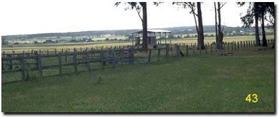 Site GP43 Landscape |
Soil Profile Morphology:
Surface Soil
| A1 | 0-15 cm | Dark brown (10YR3/3); light fine sandy clay loam; moderate polyhedral, parting to moderate fine polyhedral structure; very firm consistence dry; pH 6.5; clear change to: | 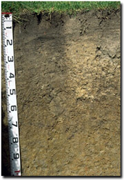 Site GP43 Profile |
| A21 | 15-30 cm | Greyish Brown (10YR5/2), sporadically bleached (10YR7/2d), with yellowish brown (10YR5/6) mottles; light fine sandy clay loam; weak coarse polyhedral structure; firm consistence dry; pH 7.0: | |
| A22 | 30-45 cm | Greyish Brown (10YR5/2) sporadically bleached (10YR7/2d), with yellowish brown (10YR5/6) mottles; heavy fine sandy clay loam; moderate coarse polyhedral structure; very firm consistence dry; contains manganese stains; pH 7.0; clear and wavy change to: | |
| Subsoil | |||
| B21 | 45-75 cm | Brown (10YR5/3) with yellowish brown (10YR5/6) mottles (fine sandy bleached material occurs along cracks and channels); medium clay; moderate coarse prismatic, parting to strong coarse blocky and moderate polyhedral structure; very firm consistence moist; pH 6.1; clear change to: | |
| B22 | 75-110+ cm | Grey (10YR6/1) with brownish yellow (10YR6/8) mottles and minor red mottles; medium clay; weak coarse prismatic, parting to moderate fine polyhedral structure; firm consistence moist; slickensides and lenticular structure at depth; pH 5.3. | |
Key Profile Features:
- Strong texture contrast between surface (A) horizons and subsoil (B) horizons.
- Sporadically bleached A2 horizon.
- Vertic properties in deeper subsoil (i.e. slickensides evident).
pH | Salinity Rating | |||
Surface (A1 horizon) | Slightly Acid | Very low | Non- Sodic | None1 |
Subsoil (B21 horizon) | Slightly Acid | Low | Sodic | Moderate2 |
Deeper subsoil (at 90 cm) | Strongly Acid | Moderate | Strongly Sodic | Strong |
 |  |  |  |
The surface and upper subsoil is slightly acid. The subsoil becomes strongly acid at 90 cm depth. |
The salinity rating is very low in the surface and upper subsoil. At 90 cm depth, the salinity rating becomes moderate. |
The surface soil is non-sodic. The subsoil is sodic becoming strongly sodic at 70 cm. |
The clay content increases significantly at the A/B horizon boundary (i.e. at 45 cm depth). |
Horizon | Horizon Depth (cm) | pH (water) | pH (CaCl2) | EC 1:5 | NaCl | Exchangeable Cations | |||
Ca | Mg | K | Na | ||||||
meq/100g | |||||||||
A1 | 0-15 | 6.5 | 5.8 | 0.1 | 7.1 | 4.3 | 1.3 | 0.42 | |
A21 | 15-30 | 7 | 6.1 | 0.1 | 3 | 3 | 1.1 | 0.42 | |
A22 | 30-45 | 7 | 6 | 0.11 | 1.8 | 3 | 1.2 | 0.59 | |
B21 | 45-75 | 6.1 | 5.2 | 0.24 | 0.58 | 4 | 1.9 | 1.5 | |
B22 | 75-110 | 5.3 | 4.8 | 0.58 | 0.13 | 0.3 | 4.5 | 0.5 | 2 |
Horizon | Horizon Depth (cm) | Exchangeable Aluminium mg/kg | Exchangeable Acidity meq/100g | Field Capacity pF2.5 | Wilting Point pF4.2 | Coarse Sand (0.2-2.0 mm) | Fine Sand (0.02-0.2 mm) | Silt (0.002-0.02 mm) | Clay (<0.002 mm) |
A1 | 0-15 | 14 | 13 | 34 | 26 | 20 | |||
A21 | 15-30 | 9.1 | 5 | 41 | 31 | 21 | |||
A22 | 30-45 | 6.4 | 9.8 | 8 | 39 | 26 | 22 | ||
B21 | 45-75 | 7.6 | 16.4 | 5 | 29 | 24 | 42 | ||
B22 | 75-110 | 18 | 20 | 3 | 22 | 21 | 55 |
Management Considerations:
Whole Profile
- Plant available water capacity (PAWC) is considered to be low-moderate (estimated at 100 mm) for the top metre of the soil profile. Effective rooting depth will be restricted by the dense and sodic subsoil. Therefore, a significant proportion of the plant available water is held in the surface (A) horizons. PAWC has been estimated here using a model developed by Littleboy (1995) which uses analytical data for clay %, fine sand %, silt %, coarse sand % and wilting point value.
- The surface (A1) horizon has a high silt and fine sand content (60%) and therefore the soil will rely to a large extent on organic matter to maintain aggregation and prevent slaking.
- The surface (A1) horizon is non-sodic but disperses slightly after remoulding. This indicates that disturbance (e.g. by tillage) to this horizon whilst in a moist to wet condition may result in structural degradation (e.g. ploughpan development).
- The inherent fertility of the surface (A1) horizon is moderate (based on the exchangeable calcium, magnesium and potassium cations). Organic matter is important for maintaining fertility on these soils.
- The subsurface (A2) horizons disperse completely after remoulding. This indicates that disturbance (e.g. by tillage) to this horizon whilst in a moist to wet condition may result in structural degradation (e.g. ploughpan development).
- The presence of sporadic bleaches and mottling within the subsurface (A2) horizons as well as the manganese stains in the A22 horizon, indicates periodic waterlogging above a more slowly permeable subsoil.
- The subsurface (A2) horizons have a low inherent fertility.
- The dense and coarsely structured upper (B21) subsoil is sodic (and has a very low exchangeable calcium to magnesium ratio) and disperses moderately (complete after remoulding). This is likely to result in restricted root and water movement down the profile. At 90 cm the profile becomes strongly sodic but the dispersion decreases, due most likely to the increase in soluble salts.
- The subsoil has a low inherent fertility throughout (based on sum of the exchangeable basic cations). Also, the relatively high exchangeable magnesium percentage may result in nutrient imbalances (e.g. potassium deficiency).
- The deeper (B22) subsoil displays vertic properties (i.e. slickensides and lenticular structure). This indicates that significant shrinking and swelling occurs during wetting and drying cycles. Subsoil cracking occurs and bleached material from above has moved down these cracks.
- The levels of soluble salts in the deeper subsoil (from 75 cm depth) are moderate. These are only likely to affect deeper-rooted highly salt sensitive species.
- The presence of mottling throughout the subsoil indicates that seasonal waterlogging may occur.
© State of Victoria (Agriculture Victoria) 1996 - .

This work, Victorian Resources Online, is licensed under a Creative Commons Attribution 4.0 licence. You are free to re-use the work under that licence, on the condition that you credit the State of Victoria (Agriculture Victoria) as author, indicate if changes were made and comply with the other licence terms.
The licence does not apply to ‘branding’ or some ‘images or photographs’ that may be owned by third parties. We ask you to seek prior approval to use images using the VRO feedback form. Access to higher quality images can also be provided on request.
This page was last updated on .