
GP42
| Location: Yarram. | Australian Soil Classification: Eutrophic, Mottled-Subnatric, Brown SODOSOL. |
| Geology: Late Pleistocene alluvial deposits. | General Landscape Description: Levee of a prior stream from the late Pleistocene period. |
| Soil Mapping Unit: Yarram. | Site Description: Grazing paddock. |
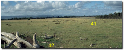 Site GP42 Landscape |
Soil Profile Morphology:
Surface Soil
| A1 | 0-20 cm | Very dark greyish brown (10YR3/2); light silty clay loam; moderate fine polyhedral structure; weak consistence dry; pH 5.5; clear change to: | 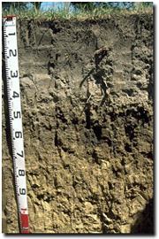 Site GP42 Profile |
| A2 | 20-45 cm | Greyish brown (10YR5/2) conspicuously bleached (10YR7/2d); silty loam; weak coarse blocky structure; firm consistence dry; contains few (2-10%) ferruginous nodules; pH 5.9; sharp change to: | |
| Subsoil | |||
| B21 | 45-60 cm | Very dark grey (10YR3/1) with faint yellowish brown (10YR5/6) mottles; medium clay; moderate coarse prismatic, parting to strong coarse blocky structure; strong consistence dry; contains manganese stains; pH 6.3; gradual change to: | |
| B22 | 60-100 cm | Brown (10YR5/3) with fine brown (7.5YR4/3) mottles (and some dark organic stains); light medium clay; moderate coarse prismatic, parting to strong coarse blocky structure; strong consistence dry; contains few (5%) manganese nodules and significant (10%) manganese staining; pH 6.8; gradual change to: | |
| B23 | 100+ cm | Brown (10YR5/3) with black (10YR2/1) stains in veins; light clay (fine sandy); moderate coarse prismatic structure; strong consistence dry; pH 6.9. |
Key Profile Features:
- Strong texture contrast between surface (A) horizons and subsoil (B) horizons.
- Conspicuously bleached subsurface (A2) horizon.
- Accumulation of manganese nodules within the subsurface (A2) and deeper subsoil.
pH | Salinity Rating | |||
Surface (A11 horizon) | Strongly Acid | Very Low | Non-Sodic | None |
Subsoil (B21 horizon) | Slightly Acid | Very Low | Sodic | Moderate |
Deeper subsoil (at 1 m) | Slightly Acid | Very Low | Sodic | Strong |
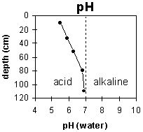 | 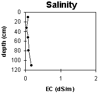 | 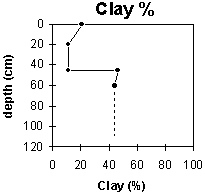 |
The surface soil is strongly acid. The subsoil is slightly acid throughout. | The salinity rating is very low throughout the profile. | The clay content increases markedly at the A / B horizon boundary (at 45 cm). |
Horizon | Horizon Depth (cm) | pH (water) | pH (CaCl2) | EC 1:5 | NaCl | Exchangeable Cations | |||
Ca | Mg | K | Na | ||||||
meq/100g | |||||||||
A1 | 0-20 | 5.5 | 4.6 | 0.08 | 4.9 | 2.9 | 0.34 | 0.57 | |
A2 | 20-45 | 5.9 | 4.6 | <0.05 | 1.8 | 2.9 | 0.17 | 0.36 | |
B21 | 45-60 | 6.3 | 5.1 | 0.08 | 2.8 | 10 | 0.35 | 1.8 | |
B22 | 60-100 | 6.8 | 5.7 | 0.1 | 2.6 | 8.9 | 0.27 | 2 | |
B23 | 100+ | 6.9 | 6.1 | 0.17 | 3 | 8.2 | 0.19 | 3.6 | |
Horizon | Horizon Depth (cm) | Exchangeable Aluminium mg/kg | Exchangeable Acidity meq/100g | Field Capacity pF2.5 | Wilting Point pF4.2 | Coarse Sand (0.2-2.0 mm) | Fine Sand (0.02-0.2 mm) | Silt (0.002-0.02 mm) | Clay (<0.002 mm) |
A1 | 0-20 | 15 | 16 | 17.4 | 3 | 35 | 34 | 21 | |
A2 | 20-45 | 8.6 | 9.2 | 2 | 41 | 36 | 21 | ||
B21 | 45-60 | 14 | 18 | 4 | 26 | 22 | 46 | ||
B22 | 60-100 | 7.2 | 17.7 | 1 | 30 | 26 | 44 | ||
B23 | 100+ | <10 |
Management Considerations:
Whole Profile
- Plant available water capacity (PAWC) is considered to be low (estimated at 85 mm) for the top metre of the soil profile. Effective rooting depth will be restricted by the dense and sodic subsoil. Therefore, a significant proportion of the plant available water is held in the surface (A) horizons. PAWC has been estimated here using a model developed by Littleboy (1995) which uses analytical data for clay %, fine sand %, silt %, coarse sand % and wilting point value.
- The surface (A1) horizon is strongly acid which indicates that aluminium toxicity may occur. However, the levels of exchangeable aluminium measured at this site are not high (i.e. 15 mg/kg). A pH/aluminium test sampled across the paddock would be most appropriate to determine whether lime is needed to raise soil pH. Other factors need to be considered before lime is recommended (e.g. pasture species grown, method of application, local trial responses, soil surface structure and likely cost/benefit).
- Deficiencies in molybdenum, potassium and phosphorus may occur. Manganese toxicity may also occur in strongly acid soils, particularly when poorly drained (as waterlogging may bring manganese into solution). Soils in low-lying positions are likely to suffer from seasonal waterlogging.
- The surface (A1) horizon has a moderate inherent fertility (based on the sum of the exchangeable calcium, magnesium and potassium cations). Organic matter is important for maintaining fertility and aggregation in such soils. The organic matter and total nitrogen levels are reasonably high.
- The surface (A1) horizon has a high silt and fine sand content (69%) and therefore the soil will rely to a large extent on organic matter to maintain aggregation and prevent slaking.
- The presence of a conspicuously bleached subsurface (A2) horizon indicates periodic waterlogging above the more slowly permeable subsoil. The inherent fertility of this subsurface layer is low as most of the nutrients have been leached out.
- The inherent fertility for the subsoil (based on the sum of the exchangeable basic cations) is moderate.
- The coarsely structured and dense subsoil is sodic and has a low exchangeable calcium to magnesium ratio (0.7). Moderate-strong dispersion occurs which will result in restricted water and root movement in the subsoil.
- The high levels of exchangeable magnesium in the subsoil may also result in nutrient imbalances. The cations are dominated by exchangeable magnesium (> 60% of total cations) which may create nutrient imbalances. For example, high levels of exchangeable magnesium may result in potassium deficiencies in some soils (Baker and Eldershaw 1993).
- The presence of mottling throughout the subsoil indicates that the profile is seasonally waterlogged.
© State of Victoria (Agriculture Victoria) 1996 - .

This work, Victorian Resources Online, is licensed under a Creative Commons Attribution 4.0 licence. You are free to re-use the work under that licence, on the condition that you credit the State of Victoria (Agriculture Victoria) as author, indicate if changes were made and comply with the other licence terms.
The licence does not apply to ‘branding’ or some ‘images or photographs’ that may be owned by third parties. We ask you to seek prior approval to use images using the VRO feedback form. Access to higher quality images can also be provided on request.
This page was last updated on .