
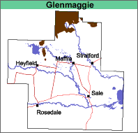
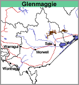
Glenmaggie (Gm)
|
|  |
Geology
Freshwater sediments deposited during the Carboniferous Period (360 to 290 mya). These sediments are mainly conglomerate, pebbly sandstone, sandstone and siltstone.
Landform
Rolling to steep low hills.
Original Vegetation
The original vegetation was an open forest. The eucalypt species present depend on aspect and surface rock outcrop (Aldrick et al. 1992). Much of the area is now largely cleared.
Previous Maps and Reports
This map unit is included within the Avon and Glenmaggie Land Systems as described by Aldrick et al. (1992).
Soils
The soils on this map unit are quite variable and have not been examined in any detail. Surface soils are dark greyish brown to dark brown loamy sands to sandy clay loams often with fragments of rock from the surface. The sub-surface may or may not be bleached. Yellowish brown to reddish brown light to medium sandy clays, generally with decomposing rock, occur from about 30 or 40 cm. The depth to rock is generally between 0.6 and 1.5 m and areas of rock outcrop without soil cover also occur. These soils could possibly be classified as stony Brown Dermosols or Chromosols using the Australian Soil Classification.
Chemical and Physical Analysis
No analyses have been carried out on any of these soils within the study area.
Land Use
Generally the map unit remains uncleared, except around Coongulla where grazing occurs. The soils have no horticultural potential.
© State of Victoria (Agriculture Victoria) 1996 - .

This work, Victorian Resources Online, is licensed under a Creative Commons Attribution 4.0 licence. You are free to re-use the work under that licence, on the condition that you credit the State of Victoria (Agriculture Victoria) as author, indicate if changes were made and comply with the other licence terms.
The licence does not apply to ‘branding’ or some ‘images or photographs’ that may be owned by third parties. We ask you to seek prior approval to use images using the VRO feedback form. Access to higher quality images can also be provided on request.
This page was last updated on .