
Giffard (Gf)
 | 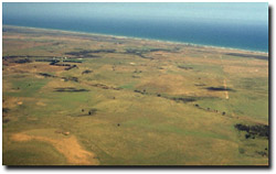 Looking over part of the Giffard plain. It is likely that these plains were originally lightly timbered with Casuarina. |
Late Tertiary deposits. The surface horizons have been modified by wind at a later time, most likely during the Recent geological period.
Landform
Level plain (often referred to as the ‘Giffard Plain’).
Land Use
Almost all of the land within this map unit is used for grazing.
Soils
The surface soils are generally around 15 to 20 cm deep and are dark grey to dark greyish brown sandy loams to loamy sands, often with small amounts of rounded gravel. There is a gradual transition to the bleached subsurface soil, typically light brownish grey to pale grey with a texture similar to the surface soil.
At between 35 and 50 cm there is an abrupt change to the medium to heavy clay subsoil which is typically yellowish brown or dark yellowish brown, frequently with dark red and light grey mottles associated with root channels. Deeper in the soil profile the soil may become sandier and the mottling more conspicuous. Soil Site GP49, a brown Sodosol, is an example of a soil on the Giffard map unit. It is highly likely that all of the soils within this map unit are Sodosols.
Within this map unit there are areas that are slightly lower in the landscape. Here the surface soils are shallower and heavier in texture and are typically sandy loams to sandy clay loams. The clay subsoils are generally duller in colour compared to the soil described above.
© State of Victoria (Agriculture Victoria) 1996 - .

This work, Victorian Resources Online, is licensed under a Creative Commons Attribution 4.0 licence. You are free to re-use the work under that licence, on the condition that you credit the State of Victoria (Agriculture Victoria) as author, indicate if changes were made and comply with the other licence terms.
The licence does not apply to ‘branding’ or some ‘images or photographs’ that may be owned by third parties. We ask you to seek prior approval to use images using the VRO feedback form. Access to higher quality images can also be provided on request.
This page was last updated on .