
Darnum (Dm)
| Geology Tertiary sediments (mostly late Tertiary). Landform Gently undulating rises (possibly a dissected paleosurface). Land use Mostly grazing (beef and dairy cattle). | 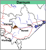 |
Soils
Apart from the soils in the drainage depressions (Component 3), the surface soils range from very dark grey clay loams to sandy loams. At about 10 to 20 cm, this overlies a light brownish grey to greyish brown similarly textured subsurface soil which is referred to as the bleached or sporadically bleached zone. Yellowish brown mottles generally develop with depth. Although light brownish grey and yellowish brown mottled clays generally occur in the deep subsoil from about 60 to 80 cm, it is convenient to separate the soils into two components (Components 1 & 2) depending on the nature or the change between the subsurface soil and the deep subsoil.
Component 1
Most of the soils within the Darnum mapping unit fall into this component. Below the bleached zone, at about 40 or 50 cm, the subsoil changes to a mottled light clay or fine sandy clay. There is a gradual change to mottled pale greyish brown and yellowish brown medium clays from about 60 to 80 cm. Soil Pit Site GP18 is an example of a Grey Dermosol near Willow Grove.
Some other sites have been examined from auger profiles:
Site War 4
Acidic, Yellow Dermosol - located near Darnum.
Surface Soil:
| A1 | 0-20 cm | Dark greyish brown (10YR4/2) clay loam; pH 5.8; abrupt change to: |
Subsoil:
| B1 | 20-55 cm | Pale brown (10YR6/3) clay loam; pH 5.4; clear change to: |
| B21 | 55-80 cm | Light yellowish brown (10YR6/4) light clay; pH 5.4; clear change to: |
| B22 | 80 cm+ | Light yellowish brown (10YR6/4) with brownish yellow (10YR6/8) mottles; medium clay; pH. |
Site War 7
Acidic, Brown Dermosol - located near Gainsborough.
Surface Soil:
| A1 | 0-30 cm | Dark brown (10YR3/3) clay loam (sandy); clear change to: |
Subsoil:
| B1 | 30-55 cm | Dark yellowish brown (10YR4/4) light clay; pH 5.1; clear change to: |
| B22 | 55-100 cm | Yellowish brown (10YR5/8) medium clay; pH 4.9. |
Component 2
The texture transition between the sub-surface soil and the medium clay subsoil is clear or abrupt. These soils commonly occur on the 'bayonet grass' country and are classified as Bleached Kurosols. This component occupies approximately 20-30% of the map unit area.
Component 3
The soils in the drainage depressions occupy less than 5% of this mapping unit. From the limited number of sites examined it is likely that most of the surface soils are generally dark grey loams to silty clay loams overlying a bleached similarly textured subsoil. Mottled light brownish grey and brownish yellow medium clays occur at about 80 to 100 cm.
Darnum with Warragul (Dm/Wg)
This mapping unit describes areas mostly comprising the Darnum mapping unit with some areas of the Warragul mapping unit. The percentage of the dominant mapping unit is at least 70%.
© State of Victoria (Agriculture Victoria) 1996 - .

This work, Victorian Resources Online, is licensed under a Creative Commons Attribution 4.0 licence. You are free to re-use the work under that licence, on the condition that you credit the State of Victoria (Agriculture Victoria) as author, indicate if changes were made and comply with the other licence terms.
The licence does not apply to ‘branding’ or some ‘images or photographs’ that may be owned by third parties. We ask you to seek prior approval to use images using the VRO feedback form. Access to higher quality images can also be provided on request.
This page was last updated on .