
Boolarra (Bl)
|
Geology |  |
Soils
| Most of the soils of this mapping unit have a grey to dark grey loam to sandy loam surface soil overlying a bleached light brownish grey to pale greyish brown similarly textured subsurface at about 10 to 20 cm. By about 40 cm the soil becomes variably mottled with yellow and brown colours and the texture may increase to a sandy clay loam. Mottled grey, yellow and brown light or medium clays occur between 40 and 80 cm. Most of this mapping unit can be subdivided into two components on the basis of whether or not there is a sharp texture change from a clay loam or a sandy clay loam to a medium clay within the soil profile. Component 1 soils which lack strong texture contrast, are the major components of this mapping unit. Component 2 soils have a marked texture contrast between the surface (A) horizons and subsoil (B21) horizon. Within the Boolarra mapping unit there may be areas of very sandy to gritty soil profiles which are described under the Morwell mapping unit. The Boolarra unit incorporates the 'Boolarra loam' soil as described by Poutsma and Turvey (1979). | 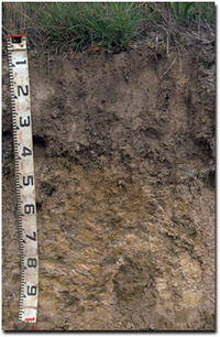 An example of a Kurosol near Traralgon. This soil type was described as 'Boolarra loam' by Poutsma and Turvey (1979). |
Component 1
These soils have a gradual texture change down the profile. Below the bleached horizon the texture increases to a clay loam then to a light clay. Medium clays occur from about 75 to 90 cm. These soils are generally classified as Acidic Dermosols using the Australian Soil Classification. Soil Pit Site GP17 is an example of an Acidic, Yellow Dermosol near Hernes Oak.
Component 2
There is a sharp texture change from a sandy loam or sandy clay loam to a medium clay at about 50 to 70 cm. These soils would generally be classified as Kurosols.
Boolarra with Morwell (Bo/Mr)
This mapping unit describes areas comprising mostly the Boolarra mapping unit with some areas of the Morwell mapping unit. The percentage of the dominant mapping unit is at least 70%.
© State of Victoria (Agriculture Victoria) 1996 - .

This work, Victorian Resources Online, is licensed under a Creative Commons Attribution 4.0 licence. You are free to re-use the work under that licence, on the condition that you credit the State of Victoria (Agriculture Victoria) as author, indicate if changes were made and comply with the other licence terms.
The licence does not apply to ‘branding’ or some ‘images or photographs’ that may be owned by third parties. We ask you to seek prior approval to use images using the VRO feedback form. Access to higher quality images can also be provided on request.
This page was last updated on .