
1. Snake Island
8120-8220 Barrier Islands, South Gippsland
This information has been developed from the publications:
|
| Location: | 535120 (8120) to 680110 (8220). Three kilometres south of Port Welshpool. | 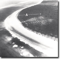 Parallel ridges, (A), at Townsend Point, Snake Island. Note new outermost marram-grass ridges. |
Access: | Boat landing may be made on part of the northern shore and along the western and southern shore by using the Lewis Channel from Port Welshpool. Landing to the east of Townsend Point is difficult due to wave conditions in Bass Strait. Landings on the sheltered north-eastern shore are made from the Snake Island Channel which is reached from Port Albert. No defined or marked channel exists across the tidal flats between the Lewis Channel and Snake Island Channel and navigation across the flats is possible only in small boats at high tide. | |
Ownership: | Crown Land. | |
Geology/Geomorphology: 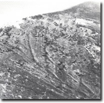 Barrier dune ridges - Snake Island. | Snake Island is the largest of the barrier islands east of Corner Inlet. The island basically is built of a complex series of sand ridges which may be grouped into several distinct sequences – each indicating a period of rapid shoreline progradation followed by partial erosion and the construction of a new series of ridges of different orientation. In both number and complexity, these ridges exceed any other group of barrier sand ridges found in the entire Corner Inlet – Ninety Mile Beach – Gippsland Lakes barrier system. The western and southern shoreline of Snake Island (i.e. the shoreline facing towards Corner Inlet and Bass Strait) is a sandy beach in most places backed by eroding older beach ridges, although a short sector of newly accreting ridges occurs near Townsend Point. The sheltered northern shoreline is bordered by wide sandy tidal flats and is indented by several mangrove fringed tidal embayments which narrow landward to become tidal creeks. Numerous small lakes and larger swamps are contained in the low lying swales between the main dune ridges. The tidal inlet (Port Albert Entrance) that marks the eastern end of Snake Island is flanked by long recurving spits that are shaped by waves and tidal currents. The tidal deltas that are adjacent to the entrance are discussed as Site 8220-3. | |
Significance: | National. The sequence of parallel and converging sand beach ridges is the most extensive on the Victorian coast and one of the best preserved such sequences on the Australian coast. The beach ridges have been very little modified by transgressive dunes and the original patterns can be clearly traced from aerial photographs and surveyed on the ground. This is a site of undoubted national significance for the study of late Pleistocene and Holocene barrier island evolution. | |
Management: | Land use that would obscure the form of the ridge systems and the associated lakes and swamps should be prohibited. Dumping of overburden from mining or dredging operations should not be permitted on the tidal flats on the northern shoreline as this would seriously interfere with the sediment patterns and mangrove ecology of that area. The mangrove flora of the island is susceptible to rapid degradation when large volumes of sand are introduced into the shore transport system. Clear examples of the die-back of mature mangroves and of the failure of seedlings to become established under these conditions are displayed at several places nearby, e.g. near the new entrance south of McLoughlans Beach. | |
References: | Jenkin, J.J. 1968. The geomorphology and upper Cainozoic geology of south-east Gippsland, Victoria. Mem. Geol. Surv. Vict., 27. | |
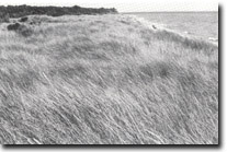 New accretion ridges at Bentley Harbour - Snake Island. | 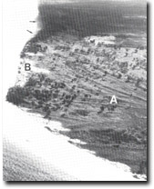 Converging barrier ridges, (A), transgressive dunes, (B), new accretion ridges, (arrowed) - Snake Island. | 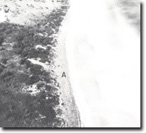 Ammophila arenaria (marram grass) ridges (A), Bentley Harbour - Snake Island. |
© State of Victoria (Agriculture Victoria) 1996 - .

This work, Victorian Resources Online, is licensed under a Creative Commons Attribution 4.0 licence. You are free to re-use the work under that licence, on the condition that you credit the State of Victoria (Agriculture Victoria) as author, indicate if changes were made and comply with the other licence terms.
The licence does not apply to ‘branding’ or some ‘images or photographs’ that may be owned by third parties. We ask you to seek prior approval to use images using the VRO feedback form. Access to higher quality images can also be provided on request.
This page was last updated on .