
7. Black Swamp
|
This information has been developed from the publications:
|
| Location: | 050705. Adjacent to South Gippsland Highway nine kilometres south of Longford. | 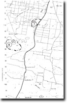 Sites 8321-7 8 |
Access: | South Gippsland Highway. | |
Ownership: | Private Land | |
Geology/Geomorphology: | Black Swamp is one of a group of lakes and swamps that form the headwaters of Boundary Creek. The swamps drain from a shallow headwater basin partly enclosed by older barrier dunes, but the valley near Black Swamp is incised into more consolidated Tertiary sediments. | |
Significance: | Local. The swamps show the impact on the drainage system of the movement of the Baragwanath Anticline and Rosedale Monocline. | |
Management: | Further draining of the wetlands would not reduce the geomorphological significance of the area as it is the form and dimension of the depressions that is of interest. | |
© State of Victoria (Agriculture Victoria) 1996 - .

This work, Victorian Resources Online, is licensed under a Creative Commons Attribution 4.0 licence. You are free to re-use the work under that licence, on the condition that you credit the State of Victoria (Agriculture Victoria) as author, indicate if changes were made and comply with the other licence terms.
The licence does not apply to ‘branding’ or some ‘images or photographs’ that may be owned by third parties. We ask you to seek prior approval to use images using the VRO feedback form. Access to higher quality images can also be provided on request.
This page was last updated on .