
6. Thomson River Anabranch - Myrtlebank
|
This information has been developed from the publications:
|
| Location: | 025845. Five kilometres north-west of Sale. | 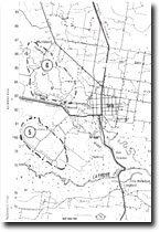 Sites 8321-5 6 |
Access: | Myrtlebank-Fulham Road. | |
Ownership: | Private Land. | |
Geology/Geomorphology: | An anabranch of the Thomson River has developed on the eastern side of the floodplain five kilometres north-west of Sale. The valley here is a complex meander plain with traces of three main channel systems. The oldest channel occupies the centre of the floodplain and has low sinuousity. Only a few abandoned meanders developed from this channel, in contrast with the numerous ox-bow lakes adjacent to the second (anabranch) channel on the eastern side of the floodplain. The present channel is undercut against the western edge of the floodplain. | |
Significance: | Regional. This is one of the best examples of anabranch development in the Gippsland stream. Detailed analysis of the meander complexity of the Thomson River and comparison with that of the anabranch would allow an assessment to be made of the time of separation of the two channels. | |
Management: | Channel straightening and drainage of meanders and cut-offs of either channel would reduce the value of the site for fluvial geomorphological analysis and should not be permitted. | |
© State of Victoria (Agriculture Victoria) 1996 - .

This work, Victorian Resources Online, is licensed under a Creative Commons Attribution 4.0 licence. You are free to re-use the work under that licence, on the condition that you credit the State of Victoria (Agriculture Victoria) as author, indicate if changes were made and comply with the other licence terms.
The licence does not apply to ‘branding’ or some ‘images or photographs’ that may be owned by third parties. We ask you to seek prior approval to use images using the VRO feedback form. Access to higher quality images can also be provided on request.
This page was last updated on .