
4. Swamp/Lake - "Eastern Downs"
|
This information has been developed from the publications:
|
| Location: | 100540. Three kilometres north-east of the “Eastern Downs” property. | 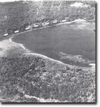 Narrow lunette ridge, (dotted), on the eastern end of lake near "Eastern Downs" |
Access: | Seaspray Road. | |
Ownership: | Private land. | |
Geology/Geomorphology: | This large inter-dune lake is aligned east-west between hummocky sand ridges. The shorelines have been modified by erosion and spit growth. The eastern shoreline has been shaped into a broad, arcuate form by the action of prevailing westerly winds and in bounded by a low, irregular ridge. This ridge is composed of peat, fine sand and silt which has been blown from the lake floor during dry periods. | |
Significance: | State. This is one of the largest inter-dune lakes that lie on the coastal terraces in the study area. It has a much higher percentage of open water area than comparible wetlands, e.g. Kangaroo Swamp and Long Swamp. It represents an active example of the relict lake and ridge terrain near Gelliondale. | |
Management: | Discharge of waste materials into the lake should be prohibited as management strategies should aim to avoid deterioration in the water quality. The lake should not be drained or reclaimed in any way. | |
References: | Jenkin, J.J. 1968. The geomorphology and upper Cainozoic geology of south-east Gippsland, Victoria. Mem. geol. Surv. Vict., 27. | |
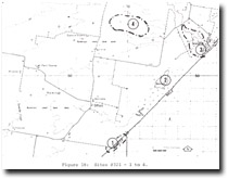 Sites 8321-1 to 4 |
© State of Victoria (Agriculture Victoria) 1996 - .

This work, Victorian Resources Online, is licensed under a Creative Commons Attribution 4.0 licence. You are free to re-use the work under that licence, on the condition that you credit the State of Victoria (Agriculture Victoria) as author, indicate if changes were made and comply with the other licence terms.
The licence does not apply to ‘branding’ or some ‘images or photographs’ that may be owned by third parties. We ask you to seek prior approval to use images using the VRO feedback form. Access to higher quality images can also be provided on request.
This page was last updated on .