
2. Lake Denison
|
This information has been developed from the publications:
|
| Location: | 130495 and coastline between 113467 and 158515. One to seven kilometres south-west of Seaspray. | 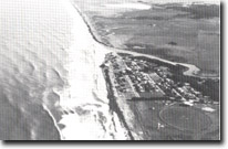 Merriman Creek delta, truncated segments, Lake Denison. |
Access: | Private road off Seaspray – Giffard Road. | |
Ownership: | Mainly private land around the lake. | |
Geology/Geomorphology: | Lake Denison is a brackish lagoon fringed by salt marsh and lies between a low, well defined bluff and the outer barrier sand ridges. Adjacent to the lake are several lagoons which represent inlets to the lake now blocked by sand. Truncated segments similar to those described near Woodside Beach occur between Lake Denison and Seaspray. | |
Significance: | Regional. The lake, barrier, bluff and the lagoonal channels represent distinctive stages in the evolution of barrier and lagoon systems. Of interest here also is the history of marram grass (Ammophila arenaria) plantings and the record of the breachings of the outer barrier by storm waves. Neither of these topics has been completely documented. | |
Management: | Reclamation and drainage of the salt marsh zone would gradually obscure the old lagoonal channels but high residual soil salinity will probably limit intensive utilisation of the lagoonal flats. Hence, localised land disturbance for further agricultural uses is unlikely to seriously alter the configuration of the significant features. | |
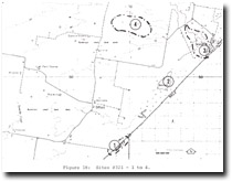 Sites 8321-1 to 4 |
© State of Victoria (Agriculture Victoria) 1996 - .

This work, Victorian Resources Online, is licensed under a Creative Commons Attribution 4.0 licence. You are free to re-use the work under that licence, on the condition that you credit the State of Victoria (Agriculture Victoria) as author, indicate if changes were made and comply with the other licence terms.
The licence does not apply to ‘branding’ or some ‘images or photographs’ that may be owned by third parties. We ask you to seek prior approval to use images using the VRO feedback form. Access to higher quality images can also be provided on request.
This page was last updated on .