
Land Degradation
Study of Landslides & their Relation to Engineering & Planning in the (former) Shire of Narracan
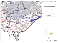 Tunnel Erosion Sites | The tunnel and gully erosion maps for the West Gippsland Catchment Management Region are subsets from the original data presented in the statewide land degradation articles on tunnel erosion and gully erosion, so that the accuracy of information has not been improved. Tunnelling was generally observed in small clusters throughout much of the region, especially in the Strzelecki ranges, around Lake Glenmaggie, and along the Avon River. However, some examples may have been destroyed (such as those discussed by Aldrick et al. in 1988) whilst new tunnels may have formed elsewhere and are not marked. |
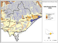 Gully Erosion Density | Similarly, the spatial distribution of gully erosion in the region may have altered since the time that the map was constructed, as may have some of the sites found more recently by Aldrick et al. (1988, 1992). The highest density of gullying was estimated at < 0.2 km/km2 near Maffra as well as the two areas mentioned above where tunnel erosion was found. Gully density was rated as ‘low’ throughout most of the southern part of the region. It should be noted, however, that this map of gully erosion density was developed as a broad statewide overview only. |
 Tunnel erosion in Strzelecki's | References Aldrick, J.M., Hook, R.A., van de Graaff, R.H.M., Nicholson, B.M., O’Beirne, D.A. and Schoknecht, N.R. (1988). 'A study of the land in the catchment of the Gippsland Lakes. Volume 1'. Department of Conservation, Forests and Lands Technical Communication No. 17. (Department of Conservation, Forests and Lands, Land Protection Division, East Melbourne) Aldrick, J.M., Hook, R.A., van de Graaff, R.H.M., Nicholson, B.M., O’Beirne, D.A. and Schoknecht, N.R. (1992). ). 'A study of the land in the catchment of the Gippsland Lakes. Volume 2'. Department of Conservation, Forests and Lands Technical Communication No. 17. (Department of Conservation and Natural Resources, Land and Catchment Protection Branch, East Melbourne) |
DPI Landcare Notes
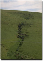
Gully erosion in south Gippsland: Gully erosion is the removal of soil along drainage lines by surface water runoff. Once started, gullies will continue to move by headward erosion or by slumping of the side walls unless steps are taken to stabilise the disturbance.
© State of Victoria (Agriculture Victoria) 1996 - .

This work, Victorian Resources Online, is licensed under a Creative Commons Attribution 4.0 licence. You are free to re-use the work under that licence, on the condition that you credit the State of Victoria (Agriculture Victoria) as author, indicate if changes were made and comply with the other licence terms.
The licence does not apply to ‘branding’ or some ‘images or photographs’ that may be owned by third parties. We ask you to seek prior approval to use images using the VRO feedback form. Access to higher quality images can also be provided on request.
This page was last updated on .