
GP75
| Location: Boisdale. | Australian Soil Classification: Humose (and Sodic), Eutrophic, Black DERMOSOL. |
| Geology: Holocene. | General Landscape Description: Avon flats. |
| Mapping Unit: Thomson. | Site Description: Dairy grazing paddock. Floods occasionally. |
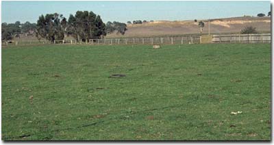 Site GP75 Landscape |
Soil Profile Morphology:
Surface Soil
| A1 | 0-30 cm | Very dark brown (10YR2/2); clay loam; moderate coarse blocky, parting to moderate medium polyhedral, parting to strong fine polyhedral structure; strong consistence dry; pH 5.4; gradual change to: | 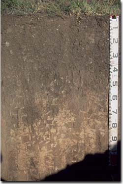 Site GP75 Profile |
| Subsoil | |||
| B21 | 30-55 cm | Very dark brown (10YR2/2); clay loam; weak coarse prismatic, parting to moderate medium polyhedral, parting to strong fine polyhedral structure; strong consistence dry; pH 6.0; clear change to: | |
| B22 | 55-90 cm | Brown (7.5YR4/4); clay loam; weak coarse prismatic structure; strong consistence dry; pores evident; pH 7.5; gradual change to: | |
| B23 | 90+ cm | Brown (7.5YR4/2) with reddish brown (5YR5/4); fine sandy clay loam; weak coarse prismatic structure; very firm consistence slightly moist; dark stains and pores evident; pH 8.3. | |
Key Profile Features:
- Lack of strong texture contrast between surface (A) horizons and subsoil (B2) horizon.
- Well structured surface soil and upper subsoil (parting to strong fine polyhedral structure).
Horizon | pH | Salinity Rating | ||
Surface (A1 horizon) | Strongly Acid | Moderate | Non-sodic | None |
Subsoil (B21 horizon) | Moderately Acid | Moderate | Non-sodic | None |
Deeper subsoil (at 90 cm) | Moderately Alkaline | High-Very High | Sodic | - |
 | The surface and upper subsoil is moderately acid. The deeper subsoil is strongly alkaline. | 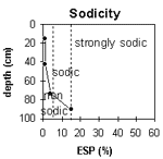 | The surface and upper subsoil is non-sodic. The subsoil becomes sodic below 70 cm depth. |
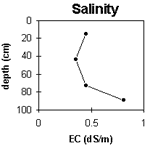 | The surface salinity rating is low to moderate. The upper subsoil rating is low becoming moderate with depth. | 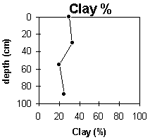 | The clay content gradually decreases with depth. |
Horizon | Horizon Depth (cm) | pH (water) | pH (CaCl2) | EC 1:5 | ESP % | Exchangeable Cations | |||
Ca | Mg | K | Na | ||||||
meq/100g | |||||||||
A1 | 0-30 | 5.4 | 4.9 | 0.45 | 16 | 4.8 | 2.2 | 0.2 | |
B21 | 30-55 | 6 | 5.4 | 0.35 | 14 | 5 | 1.7 | 0.2 | |
B22 | 55-90 | 7.5 | 7 | 0.45 | 5.4 | 2.1 | 1.7 | 0.3 | |
B23 | 90+ | 8.3 | 8 | 0.81 | 4.7 | 4.6 | 0.3 | 1.6 | |
Horizon | Horizon Depth (cm) | Exchangeable Aluminium mg/kg | Exchangeable Acidity meq/100g | Wilting Point pF2.5 | Wilting Point pF4.2 | Coarse Sand (0.2-2.0 mm) | Fine Sand (0.02-0.2 mm) | Silt (0.002-0.02 mm) | Clay (<0.002 mm) |
A1 | 0-30 | <10 | 16.6 | 4 | 21 | 36 | 30 | ||
B21 | 30-55 | <10 | 8.1 | 14.1 | 2 | 22 | 37 | 33 | |
B22 | 55-90 | 7.7 | 7.7 | 11 | 41 | 28 | |||
B23 | 90+ | 10.7 | 1 | 41 | 33 | 25 |
Management Considerations:
Whole Profile
- Plant Available Water Capacity (PAWC) is considered to be relatively high (estimated at 130 mm) for this soil profile. This is based on an estimated effective rooting depth of 55 cm (i.e. surface soil and upper subsoil). The denser and more coarsely structured deeper subsoil is likely to restrict rooting depth, although not to the same extent as some of the more sodic subsoils in the region. Much of the plant available water (i.e. 70 mm) will be in the surface (A1) horizon. PAWC has been estimated using a model developed by Littleboy (1995) which uses analytical data for clay%, silt%, fine sand%, coarse sand % and wilting point.
- Infiltration of water will be rapid throughout the upper soil profile due to the well developed soil structure and pore space available.
- The surface soil is well structured (parting to many fine polyhedral shaped peds). This will provide few restrictions for plant root development.
- Within the strongly acid surface (A1) horizon, the level of exchangeable aluminium is very low (<10 mg/kg). These levels are unlikely to adversely affect plant growth. A pH/aluminium test on a bulked sample (from across the paddock) would be appropriate to determine if lime is needed to raise soil pH
- Deficiencies in molybdenum and phosphorus may occur in the strongly acid surface soil
- The level of soluble salts in the surface is moderate and may restrict the growth of salt sensitive species. These levels are likely to be unnaturally high due to the effects of the dry season at time of sampling (i.e. summer 1997) and are likely to decline following heavy rains and/or irrigation
The nutrient holding capacity of the surface (A1) horizon (based on the sum of the exchangeable calcium, magnesium and potassium cations) is high. The high levels of organic matter at this site are important for enhancing soil fertility, water holding capacity and surface soil structure. Nitrogen levels are also high, reflecting the high organic matter levels
- The upper subsoil is also well structured (parting to many fine polyhedral shaped peds) which will promote root and water movement
- The subsoil becomes sodic and highly saline at 90 cm depth but this will only affect root development of very deep rooted salt sensitive species
© State of Victoria (Agriculture Victoria) 1996 - .

This work, Victorian Resources Online, is licensed under a Creative Commons Attribution 4.0 licence. You are free to re-use the work under that licence, on the condition that you credit the State of Victoria (Agriculture Victoria) as author, indicate if changes were made and comply with the other licence terms.
The licence does not apply to ‘branding’ or some ‘images or photographs’ that may be owned by third parties. We ask you to seek prior approval to use images using the VRO feedback form. Access to higher quality images can also be provided on request.
This page was last updated on .