
SFS21
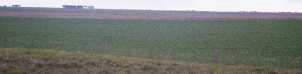
Location: East of Lake Weering
Aust. Soil Class.: Melanic, Hypercalcic, Black VERTOSOL (or DERMOSOL) (Clayey)
General Landscape Description: Lunette
Element: Crest
Slope: 3%
Aspect: West
Geology: Quaternary aeoliandeposits: sand, clay, calcareous sand
 SFS 21 |
Soil Profile Morphology:
| Surface Soil | 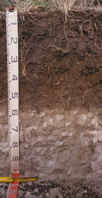 SFS 21 | ||
| A11 | 0-10 cm | Black (10YR 2/1); heavy clay loam to light clay; fine crumb structure (self mulching); pH 6.3; clear change to: | |
| A12 | 10-30 cm | Black (10YR 2/1); light clay; rough peds, fine to medium (5-20 mm) polyhedral structure, strong consistence; pH 6.3; clear change to: | |
| Subsoil | |||
| B21 | 30-60 cm | Very dark grey (7.5YR 3/1 moist), dark brown (10YR 3/3 dry); light medium clay; moderate coarse polyhedral parting to strong fine polyhedral structure; pH 6.3; clear change to: | |
| B22k | 60-130+ cm | Light brownish grey (2.5Y 6/2); light medium clay; apedal but very common fine pores and some larger root channels infilled with A and B horizon material; very calcareous; pH 8.5. | |
Key Profile Features:
- Well structured soil profile.
- Very calcareous in deeper subsoil.
Soil Profile Characteristics:
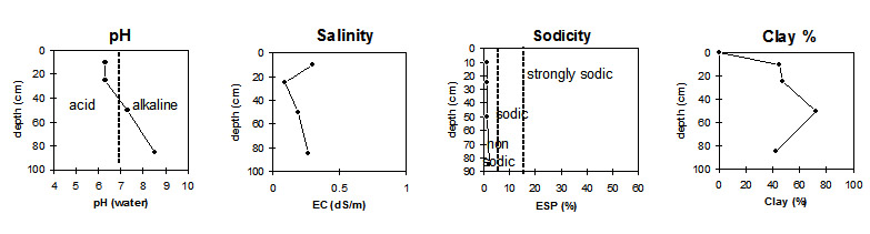
pH | Salinity Rating | |||
Surface (A1 horizon) | Slightly Acid | Low | Non-Sodic | None |
Subsoil (B21 horizon) | Slightly Alkaline | Low | Non-Sodic | None1 |
Deeper subsoil (at 75-85 cm) | Moderately Alkaline | Low | Non-Sodic | None |
 |
Horizon | Horizon Depth (cm) | pH (water) | pH (CaCl2) | EC dS/m | NaCl | Exchangeable Cations | |||
Ca | Mg | K | Na | ||||||
meq/100g | |||||||||
A1 | 0-10 | 6.3 | 5.9 | 0.30 | 0.04 | 11.0 | 5.5 | 2.3 | 0.3 |
A12 | 15-25 | 6.3 | 5.7 | 0.09 | 12.0 | 8.0 | 2.6 | 0.27 | |
B21 | 40-50 | 7.3 | 6.8 | 0.19 | 18.0 | 16.0 | 2.6 | 0.41 | |
B22k | 75-85 | 8.5 | 8.0 | 0.26 | 59.0 | 37.0 | 4.0 | 2.0 | |
Horizon | Horizon Depth (cm) | Exchangeable Aluminium mg/kg | Exchangeable Acidity meq/100g | Field Capacity pF2.5 | Wilting Point pF4.2 | Coarse Sand (0.2-2.0 mm) | Fine Sand (0.02-0.2 mm) | Silt (0.002-0.02 mm) | Clay (<0.002 mm) |
A1 | 0-10 | 36.3 | 20.9 | 12.3 | 18.5 | 15.5 | 45 | ||
A12 | 15-25 | <10 | 8.7 | 33.2 | 20.6 | 15.8 | 17.1 | 12.5 | 47.5 |
B21 | 40-50 | 48.6 | 31.4 | 5.2 | 7.7 | 7 | 72 | ||
B22k | 75-85 | 25.2 | 14.0 | 3.2 | 6.5 | 9.0 | 42.5 |
Management Considerations:
- The lunette soils in the Victorian Volcanic Plain may have sandy or clay profiles, with clay profiles, as in this case (SFS21), being generally more common. Occurrence is very localised and of limited spatial extent. The soils are well structured and have high fertility. Site drainage is usually good but because the clay content is high and the clays swell, internal drainage is often poor and the soil surface becomes sticky and difficult to manage when wet.
Whole Profile
- Plant available water capacity (PAWC) is considered to be medium (estimated at 125 mm) in the upper 100 cm of this soil profile.
- Profile described by Richard MacEwan & Mark Imhof, June 2000.
© State of Victoria (Agriculture Victoria) 1996 - .

This work, Victorian Resources Online, is licensed under a Creative Commons Attribution 4.0 licence. You are free to re-use the work under that licence, on the condition that you credit the State of Victoria (Agriculture Victoria) as author, indicate if changes were made and comply with the other licence terms.
The licence does not apply to ‘branding’ or some ‘images or photographs’ that may be owned by third parties. We ask you to seek prior approval to use images using the VRO feedback form. Access to higher quality images can also be provided on request.
This page was last updated on .