
SFS 19a
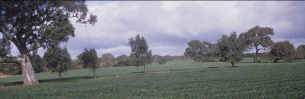
Location: Teesdale-Inverleigh Road
Aust. Soil Class.: Ferric, Subnatric, Brown SODOSOL
General Landscape Description: Level Plain, "top paddock"
Site Description: Level plain, but closer to side of Leigh River Valley
 SFS 19a |
Soil Profile Morphology:
| Surface Soil Ap A2 Subsoil B21 | 0-15/18 cm 10-30 cm | Sandier and more prone to wind erosion: Distinguish A21 and A22; extending to 45 cm depth; minor gravel confined to <10 cm above B21; conspicuously bleached (10YR 7/2 dry); 50-70% gravel 5-20 mm: Wetter subsoil conditions indicated. Coarse units similar to SFS19 but less fractured. Common manganiferous coatings inside peds. | 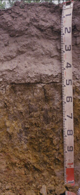 SFS 19a |
Key Profile Features:
| |||
Soil Profile Characteristics:
pH | Salinity Rating | |||
Subsoil (B21 horizon) | Near Neutral | Very Low | Sodic | None1 |
Horizon | Horizon Depth (cm) | pH (water) | pH (CaCl2) | EC dS/m | NaCl | Exchangeable Cations | |||
Ca | Mg | K | Na | ||||||
meq/100g | |||||||||
B21 | 55-65 | 7.1 | 6.5 | 0.24 | 0.08 | 4.3 | 12 | 0.53 | 2.2 |
Horizon | Horizon Depth (cm) | Exchangeable Aluminium mg/kg | Exchangeable Acidity meq/100g | Field Capacity pF2.5 | Wilting Point pF4.2 | Coarse Sand (0.2-2.0 mm) | Fine Sand (0.02-0.2 mm) | Silt (0.002-0.02 mm) | Clay (<0.002 mm) |
B21 | 55-65 | 40.1 | 28.1 | 5.7 | 4.4 | 4.0 | 85.0 |
Notes
- Profile described by Richard MacEwan & Mark Imhof, June, 2000.
© State of Victoria (Agriculture Victoria) 1996 - .

This work, Victorian Resources Online, is licensed under a Creative Commons Attribution 4.0 licence. You are free to re-use the work under that licence, on the condition that you credit the State of Victoria (Agriculture Victoria) as author, indicate if changes were made and comply with the other licence terms.
The licence does not apply to ‘branding’ or some ‘images or photographs’ that may be owned by third parties. We ask you to seek prior approval to use images using the VRO feedback form. Access to higher quality images can also be provided on request.
This page was last updated on .