
SFS16
Location: PVI Hamilton
Australian Soil Classification: Haplic, Self-mulching, Black VERTOSOL
Northcote Factual Key: Ug 5.16
Great Soil Group: Possibly Wiesenboden.
Geology: Alluvium overlying Tertiary/ Quaternary basalt Newer Volcanics.
General Landscape Description: Drained swamp.
Soil Mapping Unit: Buckley Clay.
Site Description: Level plain (part of a former swamp).
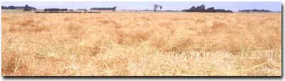 Site SFS16 Landscape |
Soil Profile Morphology:
Surface Soil
| Ap | 0-20 cm | Very dark grey (10YR3/1); heavy clay; strongly pedal; self mulching surface, polyhedral (2-20 mm) structure; clear change to: | 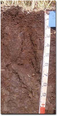 Site SFS16 Profile |
| Subsoil | |||
| B21t | 20-60/70 cm | Very dark grey (10YR3/1); heavy clay; strong coarse prismatic structure; slickensides at ped bases; clear change to: | |
| B22ss | 60/70-100/110 cm | Grey (5Y5/1) with common (20%) fine to medium yellowish brown (10YR5/6) mottles; heavy clay; prominent slickensides becoming larger (>30 cm) at depth; gradual change to: | |
| B23ss | 110+ cm | Pale olive (5Y6/4) with common fine yellowish brown (10YR5/6) mottles; heavy clay; prominent slickensides. | |
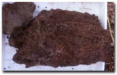 Subsoil Ped | |||
Key Profile Features:
- Clay texture throughout soil profile
- Significant cracking when profile is dry.
- Prominent slickensides in subsoil.
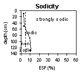
pH | Salinity Rating | |||
Surface (A1 horizon) | Strongly Acid | Low | Non Sodic | None |
Subsoil (B21 horizon) | Moderately Acid | Low | Non Sodic | None 1 |
Deeper Subsoil (at 130+ cm) | Slightly Alkaline | Low | Sodic | None 1 |
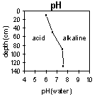 | 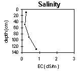 |  |  |
Horizon | Horizon Depth (cm) | pH (water) | pH (CaCl2) | EC 1:5 | NaCI % | Exchangeable Cations | |||
Ca | Mg | K | Na | ||||||
meq/100g | |||||||||
Ap | 0-10 | 6.0 | 5.3 | 0.23 | 16 | 18 | 0.68 | 1.5 | |
B21 | 10-50 | 6.6 | 5.6 | 0.16 | 15 | 21 | 0.84 | 2.2 | |
B22 | 50-90 | 7.5 | 6.8 | 0.41 | 0.07 | 15 | 26 | 0.7 | 4.4 |
B23 | 90-130 | 7.6 | 7.1 | 0.81 | 0.14 | 13 | 25 | 0.9 | 4.8 |
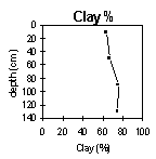
Horizon | Horizon Depth (cm) | Exchangeable Aluminium mg/kg | Exchangeable Acidity meq/100g | Field Capacity pF2.5 | Wilting Point pF4.2 | Coarse Sand (0.2- 2.0 mm) | Fine Sand (0.02- 0.2 mm) | Silt (0.002- 0.02 mm) | Clay (<0.002 mm) |
Ap | 0-10 | 11 | 21 | 56 | 36 | 2 | 10 | 14 | 63 |
B21 | 10-50 | 16 | 59 | 33 | 1 | 9 | 18 | 67 | |
B22 | 50-90 | 58 | 40 | 1 | 8 | 12 | 75 | ||
B23 | 90-130 | 1 | 7 | 10 | 74 |
Management Considerations:
Whole Profile
- Plant available water capacity (PAWC) is considered to be high (estimated at 167 mm) in the upper 100 cm of this soil profile.
Profile Described By: Richard MacEwan, 7 December 1999.
© State of Victoria (Agriculture Victoria) 1996 - .

This work, Victorian Resources Online, is licensed under a Creative Commons Attribution 4.0 licence. You are free to re-use the work under that licence, on the condition that you credit the State of Victoria (Agriculture Victoria) as author, indicate if changes were made and comply with the other licence terms.
The licence does not apply to ‘branding’ or some ‘images or photographs’ that may be owned by third parties. We ask you to seek prior approval to use images using the VRO feedback form. Access to higher quality images can also be provided on request.
This page was last updated on .