
SFS15
Location: PVI Hamilton
Australian Soil Classification: Ferric-Sodic, Eutrophic, Brown CHROMOSOL
Northcote Factual Key: DY3.22
Great Soil Group: Possibly brown podzolic.
Geology: Tertiary/Quaternary basalt.
General Landscape Description: Southerly aspect, simple slope (1%), relatively elevated position in a gently undulating basalt plain. Land surface moderately gilgaied, with puffs at 2-4 metre intervals and a relative relief of 100 mm or less.
Soil Mapping Unit: Monivae gravelly loam (slope phase) (Martin and Maher 19).
Site Description: Pasture paddock. Proposed site for raised bed research (Phil Newton). The face of the pit showed gilgai ‘puff’ features, while the sides and rear of the pit showed gilgai features associated with ‘hollow’. There was a thick A2 horizon in the hollow and a very high (>80%) amount of buckshot (3-10 mm) which was mostly magnetic, irregular rounded or sub-rounded (pitted).
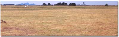 Site SFS15 Landscape |
Soil Profile Morphology:
Surface Soil
| A1 (Ap) | 0-20 cm | Very dark greyish brown (10YR3/2), greyish brown dry (10YR5/2d) ; fine sandy clay loam; weakly to moderately pedal; fine to medium sub-angular blocky to polyhedral; firm consistence dry, weak consistence moist; clear change to: | 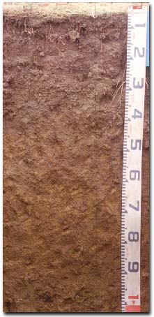 Site SFS15 Profile |
| A2c | 20-35 cm | Dark brown (10YR3/3), puff - greyish brown dry (10YR5/2d), hollow - light greyish brown dry (10YR6/2d); gravelly loam; with hard magnetic ferro-manganiferous concretions (3-10 mm); pH 5.6; clear boundary change to: NOTE: In the hollow there is a smooth and wavy boundary up to 50 cm in depth. | |
| Subsoil | |||
| B21t | 35-100 cm | Yellowish brown (10YR5/4) with fine yellowish brown (10YR5/8) and brown (10YR4/3) mottles; light medium clay; fine buckshot (>10%); pH 6.6; clear change to: | |
| B22t(ss) | 100+ cm | Grey (N6) with brownish yellow (10YR6/8) mottles; light olive brown (2.5Y5/3) with yellowish brown (10YR5/8) mottles; medium heavy to heavy clay; no buckshot; horizon cracked to base of pit and fissure traceable through B21 above; stress cutans (slickensides) on ped faces; pH 6.6. | |
 Puff and Hollow. | 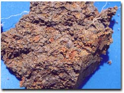 Subsoil Mottling. |
Key Profile Features:
- Lateral variation in the soil profile features association with gilgai microrelief.
- Strong texture contrast between the surface (A) horizons and the subsoil (B21) horizon.
- Ferruginous nodules (‘buckshot’) in subsurface (A2) horizon.
Soil Profile Characteristics:
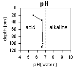
pH | Salinity Rating | |||
Surface (A1 horizon) | - | - | - | - |
Subsoil (B21 horizon) | Slightly Acid | Low | Non-Sodic | None |
Deeper Subsoil (at 100+cm) | Slightly Acid | Low | Sodic | None |
 | 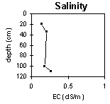 | 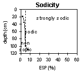 |  |
Horizon | Horizon Depth (cm) | pH (water) | pH (CaCl2) | EC 1:5 | Exchangeable Cations | |||
Ca | Mg | K | Na | |||||
meq/100g | ||||||||
A2 | 20-35 | 5.6 | 5.0 | 0.14 | 3.1 | 1.6 | 0.11 | 0.27 |
B21 | 40-60 | 6.6 | 6.0 | 0.20 | 8.1 | 9.4 | 0.25 | 1.4 |
B21 | 60-80 | 6.7 | 6.1 | 0.18 | 6.5 | 9.1 | 0.23 | 1.7 |
B22 | 100+ | 6.6 | 6.0 | 0.27 | 6.5 | 12 | 0.1 | 2.7 |
Horizon | Horizon Depth (cm) | Exchangeable Aluminium mg/kg | Exchangeable Acidity meq/100g | Field Capacity pF2.5 | Wilting Point pF4.2 | Coarse Sand (0.2- 2.0 mm) | Fine Sand (0.02- 0.2 mm) | Silt (0.002- 0.02 mm) | Clay (<0.002 mm) |
A2 | 20-35 | <10 | 9.6 | 28 | 10 | 20 | 34 | 22 | 21 |
B21 | 40-60 | 14 | 50 | 33 | 2 | 8 | 7 | 81 | |
B21 | 60-80 | 14 | 49 | 31 | 3 | 9 | 7 | 78 | |
B22 | 100+ | 13 | 3 | 9 | 12 | 73 |
Management Considerations:
Whole Profile
- Plant available water capacity (PAWC) is considered to be medium (estimated at 110 mm) in the upper 100 cm of this soil profile.
Profile Described By: Richard MacEwan, 7 December 1999.
© State of Victoria (Agriculture Victoria) 1996 - .

This work, Victorian Resources Online, is licensed under a Creative Commons Attribution 4.0 licence. You are free to re-use the work under that licence, on the condition that you credit the State of Victoria (Agriculture Victoria) as author, indicate if changes were made and comply with the other licence terms.
The licence does not apply to ‘branding’ or some ‘images or photographs’ that may be owned by third parties. We ask you to seek prior approval to use images using the VRO feedback form. Access to higher quality images can also be provided on request.
This page was last updated on .