
Salinity Provinces in the West Gippsland Catchment Management Region
Situated in the southeast to central parts of Victoria, the West Gippsland CMA Region is bounded by the Victorian Great Dividing Range in the north and Gippsland coast in the south. Major landform elements in the region where salinity problems tend to be found include the coastal areas of Wonthaggi – Inverloch, Corner inlet – Yarram coast and the Macalister – Lake Wellington areas at the eastern end of the Latrobe Valley.
The region has a Mediterranean climate with maximum temperatures and minimum rainfall occurring in summer. This is tempered in coastal areas creating milder temperatures and a more evenly distributed annual rainfall. The mean annual precipitation varies considerably with elevation, with upland areas sometimes receiving three times the rainfall of lowlands. Annual average precipitation ranges from less than 700 mm at Sale to over 1300 mm at Erica.
The majority of the lowland and coastal southern half of the region has been cleared for agriculture, with the predominant land-use grazing. Public land retained under forest occurs in the upland northern part as well as in significant parts of the Strezlecki ranges, along with substantial plantations.
Dryland salinity occurrence is often associated with high watertables in coastal areas, or with cleared catchments and break-of-slope Groundwater Flow Systems in more elevated farming locations. The Macalister Irrigation Region around Maffra and Sale has high watertables and some salinity management issues similar to those found in the northern Victorian irrigation areas.
Salinity has been recorded at over 260 individually mapped units1, with a total area of approximately 16,770 hectares1 . Across the region, eight Salinity Provinces (including five 'High' priority Provinces) have been defined based on these salinity occurrences. Three of these Provinces are found inland and the other 5 adjoining the coast.
The West Gippsland CMA has an extensive range of online materials (maps and documents etc.) which outline the biophysical assets of the catchment, as well as their major risks (including soil and water salinity). This material also outlines the programs and projects currently being completed by the CMA to protect and enhance these assets. An example of this is the West Gippsland CMA ‘Waterway Strategy 2014 - 2022’, the link to which can be found at the base of this page.
Provinces displayed in this map are clickable or use the table of links provided
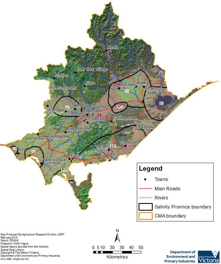
Province Name | No. | Area of Province (ha) | Recorded Soil Salinity Area 1 (ha) | Soil Salinity Area (% of SP) |
| Hicksborough | 45 | 4,400 | 458 | 10.42% |
| Inverloch | 51 | 24,570 | 1,180 | 4.80% |
| Lake Wellington | 58 | 101,830 | 12,356 | 12.13% |
| Macalister | 68 | 117,400 | 0 | 0% |
| Moe Basin | 76 | 48,000 | 0 | 0% |
| Rosedale | 104 | 13,140 | 468 | 3.56% |
| Woodside - Yarram | 135 | 164,260 | 1,953 | 1.19% |
| Yanakie | 139 | 14,200 | 300 | 2.11% |
1 Please Note: The ‘Recorded Soil Salinity Area’ and ‘number of individually mapped units’ indicated in the CMA text and/or table, comprises the total geographic area or number of sites that have been mapped as having, or showing symptoms of dryland soil salinity at some time (past or present). As dryland salinity occurrence in the Victorian landscape exhibits many different levels of severity and can change due to climate, landuse and vegetation, previously mapped areas may no longer be showing symptoms. In addition, as not all parts of the state have been mapped, or mapped in the same way, the mapping may not have captured some occurrences.
Recorded soil salinity mapping used for these pages does not cover irrigation regions. Instead, depth to watertable and watertable salinity mapping has been used to convey the threat of high watertables on soil waterlogging and/or soil salinisation.
Please contact the Department, your Catchment Management Authority or your rural water provider for more information about salinity in your location.
Links to further reading and material related to the West Gippsland CMR
West Gippsland Catchment Management Authority region on VRO
West Gippsland Catchment Management Authority
West Gippsland CMA ‘Regional Catchment Strategy ’ (RCS)
West Gippsland CMA ‘Waterway Strategy 2014 - 2022’
Information about bores and groundwater resources in the West Gippsland CMA can be found on the Visualising Victoria’s Groundwater (VVG) website
© State of Victoria (Agriculture Victoria) 1996 - .

This work, Victorian Resources Online, is licensed under a Creative Commons Attribution 4.0 licence. You are free to re-use the work under that licence, on the condition that you credit the State of Victoria (Agriculture Victoria) as author, indicate if changes were made and comply with the other licence terms.
The licence does not apply to ‘branding’ or some ‘images or photographs’ that may be owned by third parties. We ask you to seek prior approval to use images using the VRO feedback form. Access to higher quality images can also be provided on request.
This page was last updated on .