
Recognising Dryland Salinity
Extent of Dryland Salinity | Technical Solutions for Dryland Salinity | Mapping and Monitoring Salinity Incidence
The major visual indicators of salinity are:
Plant indicators
| Salt-tolerant plants (or indicator plants) The most common method for recognising salinity is the presence of known salt-tolerant plant species (or indicator plants). Salt-tolerant species are able to grow in saline soils. Each species has a specific range of tolerable soil salinity. The presence of two to three known salt-tolerant species with any of the other indicators (presence of groundwater, bare soil, salt, or low position in the landscape) generally confirms salinity. In the absence of known salt-tolerant plants it is necessary to examine the plants present for physical evidence of salt-tolerance such as thickening of the leaf surface, reduction of leaf hairiness, semi-succulence in leaves and stunting and reddening of the plant. Salt-sensitive plants Salt-sensitive plants includes most crop and pasture species, and physical changes often indicate salinity. One or more of the following changes may be observed in populations of salt-sensitive plants in a newly emergent discharge site and/or sites with low levels of salinity in general:
| 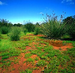 |
In pasture and natural vegetation affected by salinity, a change would be evident over a number of seasons to a dominance by annuals.
Grasses and clovers drop-out with increasing salinity while species in the rush and sedge groups thrive.
Limitations of the method
If assessment is taking place in years of below average rainfall there may be very little plant germination or growth. The availability of plants as salt indicators will be restricted.
In an average year, the wetter months of winter are not the best for looking for salinity. This is because the rainfall dilutes the soil salinity to a point that may allow short-lived plants that would not tolerate the salty conditions in summer to establish. This can be misleading, and for this reason salinity assessment is best undertaken in drier months. In years of above average rainfall the full extent of salinity may be underestimated due to the same effect.
Cultivation, slashing or harvesting of paddocks can conceal the presence of salinity at a site. This is termed ‘masking’, and in such cases the site can be reassessed when the next crop or pasture has developed.
Surface water
Free water or dampness at the ground surface (particularly in summer) may be due to groundwater discharge. Recent rainfall events and waterlogging are other possible causes. Free water can be analysed for salt using a field electroconductivity (EC) meter. Any water registering above 500 microsiemens per centimetre (µScm-1) in winter is probably groundwater.
Bare soil
Plant cover is lost due to death of the original salt-sensitive native vegetation, crop or pasture. Once bare, soil is prone to erosion and salt accumulates at an accelerated rate. Stock can exacerbate bare soil as they like the cool and salty conditions found at a discharge site, and will preferentially camp on these sites.
At extremely high levels of salinity no plants can tolerate the conditions and this results in a permanent salt pan.
Salt stains
On bare soil, salt is sometimes observable as a white stain, or as actual salt crystals (an encrustation). This is one of the more definitive indications of salinity. The stain or encrustation may be tasted for confirmation.
Position in the landscape
Salinity generally occurs in lower parts of the landscape: on flats, drainage lines, lake margins, stream banks and in depressions.
Local groundwater aquifer systems have watertables that generally follow surface topography. Regional groundwater aquifer systems have flat or gently sloping watertables that extend under a number of surface water catchments.
Break-of-slope describes a change in surface gradient to a more gentle slope. The breaks are found in general at the foot of hills. The breaks are correlated with an increase in clay thickness, which causes groundwater to 'slow down' and consequently discharge.
Perched watertables, caused by an aquifer overlying a confining (usually clay) layer, discharge as hillside seeps, a less common form of salinity.
© State of Victoria (Agriculture Victoria) 1996 - .

This work, Victorian Resources Online, is licensed under a Creative Commons Attribution 4.0 licence. You are free to re-use the work under that licence, on the condition that you credit the State of Victoria (Agriculture Victoria) as author, indicate if changes were made and comply with the other licence terms.
The licence does not apply to ‘branding’ or some ‘images or photographs’ that may be owned by third parties. We ask you to seek prior approval to use images using the VRO feedback form. Access to higher quality images can also be provided on request.
This page was last updated on .