
Extent of Dryland Salinity
Geology and dryland salinity | Recognising Dryland Salinity | Technical Solutions for Dryland Salinity | Mapping and Monitoring Salinity Incidence
| A large area of Victoria is affected by dryland salinity. The total area of secondary (or induced) dryland salinity in Victoria is approximately 120 000 hectares, or about 1 % of the dryland agricultural land in the state. A proportion of dryland salinity has been mapped, although salinity mapping is an on-going process. Figure above shows the dryland agricultural areas in Victoria affected by dryland salinity as mapped in the Victorian Soil Salinity Monitoring Project, funded by the Department of Sustainability and Environment (DSE) in 2007. Each dot in the figure above represents the centre of a salinity site. The size of the dot used on the map under represents some sites and over represents others. The actual size of the sites varies from less than one hectare to more than 2000 hectares. Fifty percent of the sites are smaller than two hectares, while just 3 % are larger than 100 hectares. Additional salinity sites are known to exist but are not yet recorded in the Glenelg, western Wimmera, western North Central and the North East catchment management regions. Further field work will reveal the full extent of salinity in these areas. In 2008 the Department of Primary Industries presented a report Dryland Salinity in Victoria in 2007 - An analysis of data from the soil salinity database and Victorian discharge monitoring network with the most current estimate of mapped soil salinity across Victoria. Where data exists, the report shows the temporal change in the extent and severity of salinity. | 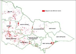 Distribution of mapped dryland salinity in Victoria |
 | Dryland salinity in Victoria in 2007 - An analysis of data from the soil salinity database and Victorian discharge monitoring network (PDF - 1293KB) Dryland salinity in Victoria in 2007 - An analysis of data from the soil salinity database and Victorian discharge monitoring network (DOC - 667KB) To view the information PDF requires the use of a PDF reader. This can be installed for free from the Adobe website (external link). |
Plains
The largest sites of dryland salinity occur on the plains of northern Victoria. In the plains areas (eg. the Wimmera Plains and the Northern Riverine Plains) regional groundwater aquifers discharge in low points in the landscape (river channels and wetlands). These aquifers may be recharged hundreds of kilometres away in the headwaters of the ancient alluvial channel systems called Deep Leads as well as more generally across the entire plains area. Establishment and astute management of higher water using vegetation such as trees and deep-rooted crops and pastures will help to control the problem.
Around Lake Wellington in West Gippsland Region large salinity sites are found which are caused by recharge in both dryland and irrigation areas of the catchment.
The basalt plains run from Melbourne, west to the South Australian border. Many salinity sites are associated with this geology.
Hills and mountains
The second most common landscapes in Victoria experiencing salinity are the bedrock (mostly sedimentary bedrock) hills of the Central and Western Highlands. Although annual rainfall is typically less than 800 mm/year, significant recharge occurs through thin, stoney soils under areas supporting shallow-rooted annual vegetation. The salinity from this recharge generally occurs locally.
Much of the bedrock in these highland areas is deeply weathered with high salt storage and the resulting rising watertables have brought much of this salt to the surface in low points and breaks of slope in the landscape.
Unlike the plains, salinity occurrence is usually associated with local scale groundwater systems. However, although the salinity sites tend to be small in comparison to those of the plains, they are numerous and pose a serious problem throughout the Central and Western Highlands.
Management of the problem is focused on re-establishing deep-rooted perennial vegetation, including trees, to make greater productive use of water from rainfall and reduce recharge and runoff.
The Eastern Highlands, Otway Ranges and Strzelecki Ranges are relatively unaffected by salinity. This is probably due to
(i) the high percentage of area still under forest cover
(ii) the generally high rainfall and good drainage in these areas. Groundwater salinities tend to be low and clearing of land in these areas more commonly leads to waterlogging than secondary salinity.
Dundas Tablelands
Salinity discharge in the Tablelands, north of Hamilton in the Glenelg Region, typically occurs along valley floors and has been associated with local groundwater systems existing within the deeply weathered material forming these tablelands.
Mallee
The Mallee region is highly salt-affected. However, approximately 85 % of salinity in the region was present before European agriculture altered the water balance. This is termed natural or primary salinity. Of the 15 000 ha of salinity identified as induced (or secondary), 12 000 ha is discharging from a regional groundwater system.
General
Dryland salinity is more prevalent in the western half of the state for the following reasons:
- Clearing of land and replacement with lower water using vegetation has been more widespread
- Lower relief and generally poorer drainage
- Generally high natural salt storage in the area.
© State of Victoria (Agriculture Victoria) 1996 - .

This work, Victorian Resources Online, is licensed under a Creative Commons Attribution 4.0 licence. You are free to re-use the work under that licence, on the condition that you credit the State of Victoria (Agriculture Victoria) as author, indicate if changes were made and comply with the other licence terms.
The licence does not apply to ‘branding’ or some ‘images or photographs’ that may be owned by third parties. We ask you to seek prior approval to use images using the VRO feedback form. Access to higher quality images can also be provided on request.
This page was last updated on .