
Step 4.1.1 - What planning issues do I need to consider?
The planning considerations focus on the following sub-questions:
Step - 4.1.1.1 - What land area and shape can I irrigate with border-check systems?
Step - 4.1.1.2 - Can undulating land be irrigated?
Step - 4.1.1.3 - What soil types are suitable for border-check?
Step - 4.1.1.4 - What are the water supply and quality issues?
Step - 4.1.1.5 - What catchment issues do I need to consider?
Step - 4.1.1.1 - What land area and shape can I irrigate with border-check systems?
| Border-check can be used to irrigate areas of virtually any shape or size. However, rectangular paddock shapes are preferred, and are most common. The dimensions, direction and slope of bays and the overall layout should be considered in the context of a Whole Farm Plan. Sections of the farm (such as a paddock) should not be considered in isolation. Although generally the overall layout is determined by topography and is relatively straightforward, compromises are often needed to achieve the layout that best suits the needs of farm operations, such as the location of feed pads, laneways, dairies, etc. |
 A whole farm plan integrates all components of the farm irrigation systems |
Step - 4.1.1.2 - Can undulating land be irrigated?
Border-check irrigation is best suited to relatively flat land. Three issues affect the suitability of undulating land for border-check irrigation – the slope, the depth of the topsoil, and the volume of earthmoving needed to achieve the desired layout:
- Slope – Slopes of 1:100 to 1:800 can be used to irrigate perennial pasture, with perhaps 1:300 to 1:600 being an optimum. For more information see the Agnote “Border-check Irrigation Design”.
- Depth of topsoil - Removal of the topsoil is a serious problem associated with landforming. It results in exposure of low fertility sub-soils with poor soil structure and texture. Where shallow topsoils (as in much of the northern Victorian irrigation areas) are landformed, they should be stripped, temporarily stockpiled and replaced after landforming.
- Earthmoving – Slopes can be changed, minor undulations can be smoothed out, and cross slope can be removed with earthmoving equipment. However, this is expensive, and an economic assessment is needed to determine if a particular option is feasible.
Step - 4.1.1.3 - What soil types are suitable for border-check?
| Soil type is an important factor where border-check irrigation is considered. In particular the infiltration and drainage characteristics of the soil are important. Infiltration On medium to heavy soils in the Shepparton Irrigation Region (SIR), such as Moira loam or Lemnos loam, initial infiltration is typically very rapid due to crack filling and adsorption into the dry soil surface, quickly slowing to a low final infiltration rate (Figure 5). While the crack-fill is largely dependent on the soil moisture deficit (the dryness of the soil) at the time of irrigation, the soil properties largely determine the final infiltration rate. Light, coarser textured soils such as Cobram loam or Shepparton fine sandy loam, do not have large cracks that rapidly fill. Initial infiltration is usually slower than cracking soils, but slows gradually to comparatively higher final infiltration rates (Figure 5). Soil properties are highly variable in these soil types. Shallow rooted crops such as pasture may not be suitable with border-check irrigation on these soils because of large, unavoidable deep drainage losses. Very light soils, such as Sandmount sand, have very high final infiltration rates which normally results in excessive infiltration and poor irrigation efficiencies. These soils may be suited to border-check irrigated lucerne, but otherwise should be avoided for border-check irrigation. For more information, see the Agnote “Border-check Irrigation Design” and Step 2.3.7.2. |
 Some soils are not suitable for border-check irrigation |
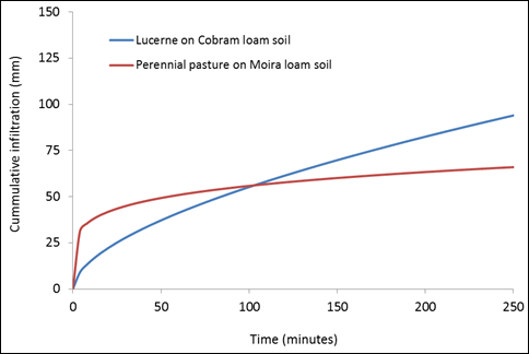
Figure 5: Cumulative infiltration on Cobram loam and Moira loam soils (north Victoria)
Drainage
Uneven microtopography within irrigation bays on medium to heavy soils can cause long durations of water ponding on bays after irrigations and rainfall, reducing soil health and productivity. On both heavy and light soils, a high water table can also slow infiltration and cause water to lie on bays for long periods.
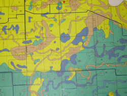
For information on soil types in the Shepparton Irrigation Region, go to Step 2.2.1
Step - 4.1.1.4 - What are the water supply and quality issues?
As with any irrigation development, a water entitlement and water use licence is needed. Information about the water requirements of perennial pasture is presented in Step 2.3.1.
- Flow rate – Border-check systems can be designed to suit a large range of flow rates (see the Agnote “Border-check Irrigation Design”). With new irrigation infrastructure development in northern Victoria, farmers may have the option to use higher bay inflow rates, which can reduce the time taken for irrigation. Selecting the appropriate irrigation duration and irrigation interval is necessary for any flow rate. However, adoption of higher inflow rates demands a higher standard of management and can increase incidence of “short” irrigations where water fails to reach the end of bays and/or large runoff volumes. Misjudging the correct irrigation duration by 10 minutes at a high inflow rate has greater consequences than the same error at a low inflow rate. Adoption of higher inflow rates requires adequate and well maintained surface drainage and reuse systems because of the greater chance of large runoff events and greater risk of consequent irrigation discharges from farms to the regional drainage network.
- Water quality – The main water quality issue is salinity (electrical conductivity, or EC), and this is normally only a concern if ground water (or in some cases surface drainage water) is being used. Contact your local DPI office for information on required shandy ratios of good-quality surface water (from the channel) with poorer quality water from the reuse system, drainage diversion, or ground water.
Step - 4.1.1.5 - What catchment issues do I need to consider?
In addition to the irrigation requirements of the site there are a number of off-farm issues that have to be considered before irrigation development can commence. These issues are discussed in Step 2.2.11. Further information relevant to border-check irrigation is given here:
- Earthworks – Border-check irrigation development typically involves significant earthworks that require a local government planning permit. These permits ensure that regional drainage is not restricted or significantly changed by the proposed works, potentially impacting upon others. To avoid having to apply for a planning permit every time you want to implement part of your whole farm plan, your council can certify the Whole Farm Plan, and you can implement it over several years. For more information, contact your local DPI office.
- Remnant vegetation – A local government planning permit is required to remove remnant native vegetation. This isn’t automatic – in some cases a permit may not be given. If a permit is issued, it is likely that a condition of the permit will be to plant “compensatory” plantings of suitable species. For more information, contact your council or the Benalla or Bendigo DSE office.
- Farm dams – Drainage reuse storages are an important component of border-check irrigation systems. New drainage reuse or irrigation storages must comply with the Victorian farm dams legislation.
Further issues discussed in Step 2.2.11 which may be relevant in some situations are:
- New Irrigation Development; and
- Farm Effluent Management.
© State of Victoria (Agriculture Victoria) 1996 - .

This work, Victorian Resources Online, is licensed under a Creative Commons Attribution 4.0 licence. You are free to re-use the work under that licence, on the condition that you credit the State of Victoria (Agriculture Victoria) as author, indicate if changes were made and comply with the other licence terms.
The licence does not apply to ‘branding’ or some ‘images or photographs’ that may be owned by third parties. We ask you to seek prior approval to use images using the VRO feedback form. Access to higher quality images can also be provided on request.
This page was last updated on .