
Regional Land Systems
The regional studies vary in terms of scale, size of area studied and survey intensity. For example, the study of the Gippsland Lakes (Aldrick et al) had a team of seven persons undertaking fieldwork over a three to four year period. Other studies such as those for some of the former Land Conservation Council (LCC) (external link) reports had much less resourcing and relied on limited field information. |
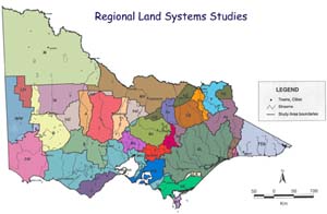
Since these reports were melded together a number of other studies have been carried out on a Catchment Management Area (CMA) basis, though many of the reports shown here have been incorporated into newer studies. Other studies at a comparable scale have been undertaken by the former Department of Agriculture, such as the large study of South-western Victoria by (Maher and Martin 1987).
Eventually it is envisaged that all the relevant studies including the more recent CMA based studies will be used to create a new statewide coverage of land types (including soil). There is still a need to have some areas surveyed (as well a revision with new new technology). Much of the public land, for example, does not have the same level of information as the freehold land, which makes developing broader overviews difficult.
Map Symbol | Reference | Map Symbol | Reference |
| Lorimer, M. S., and Rowan, J. N. (1982). A Study of the Land in the Catchment of the Avoca River. Technical Communication No. 15. former Soil Conservation Authority, Victoria | Imhof, M., Thompson, S., and Rees, D. B. (1995). Major Agricultural Soils in the Shire of Lowan, Stage One Interim Report former Depts. of Agriculture & Dept. of Conservation and Natural Resources, Victoria | ||
| Rowe, R. K. (1977) Land Systems. Report on the Alpine Study Area. former Land Conservation Council. | Rowan, J. N. and Downes, R. G. (1963). A Study of the Land in North-Western Victoria. Technical Communication No. 2. former Soil Conservation Authority | ||
| Lorimer, M. S. (1980). Land Systems. Report on the Ballarat Area. former Land Conservation Council | Jeffrey, P. J. (1981). A Study of the Land in the Catchments to the North of Melbourne. former Soil Conservation Authority. | ||
| Rundle, A. S. and Rowe, R. K. (1974) A Study of the land in the Catchment of the Broken River Technical Communication No. 9 former Soil Conservation Authority, Victoria | Lorimer, M. S. and Schoknecht, N. R. (1983). Land Systems. Report on the Murray Valley Study Area. former Land Conservation Council | ||
| Lorimer, M. S. and Schoknecht, N. R. (1987). A Study of the Land in the Campaspe River Catchment. Technical Communication No. 18. former Land Protection Division, Dept. of Conservation Forests & Lands, Victoria | Lorimer, M. S. (1978). Land Systems. Report on the North Central Area. former Land Conservation Council | ||
| Rundle, A. A. (1977). A Study of the Land in the Catchment of Lake Eildon. Technical Communication No. 11. former Soil Conservation Authority, Victoria. | Rowe, R. K. (1984). Land Systems. Report on the North-east Study Area (Benalla-Upper Murray) Review. former Land Conservation Council. | ||
| Nicholson, B. M. (1974). Land Systems. Report on the East Gippsland Area. former Land Conservation Council. | Pitt, A. J. (1981). A Study of the Land in the Catchment of the Otway Ranges and Adjacent Plains. Technical Communication No. 14. former Soil Conservation Authority, Victoria. | ||
| Rees, D. B. (1996). Land Inventory in East Gippsland - A Reconnaissance Study. Technical Report No. 23, Centre for Land Protection Research, DNRE, Victoria. | Rowe, R. K. (1984). A Study of the Land in the Catchments of the Upper Ovens and King Rivers. Technical Communication No. 16. former Soil Conservation Authority, Victoria. | ||
| Sibley, G. T. (1967). A Study of the Land in the Grampians Area. Technical Communication No. 4. former Soil Conservation Authority, Victoria. | Van de Graaf, R. H. M. and Hook, R. A. (1980). Land Systems. Report on the South Gippsland Study Area - District 2. Land Conservation Council | ||
| Aldrick, J. M., Hook, R. A., van de Graaf, R. M., Nicholson, B. M., O'Beirne, D. A. and Schoknecht, N. R. (1988). A Study of the Land in the Catchment to the Gippsland Lakes, Volume 1. Technical Communication No. 17. former Land & Catchment Protection Branch, Dept. Conservation & Natural Resources. Aldrick, J. M., Hook, R. A., van de Graaf, R. H. M., Nicholson, B. M., O'Beirne, D. A. and Schoknect, N. R. (1992) A Study of the Land in the Catchment to the Gippsland Lakes, Volume 2. Technical Communication No. 17. former Land & Catchment Protection Branch, Dept. Conservation & Natural Resources. | Gibbons, F. R. and Downes, R. G. (1964). A Study of the Land in South-western Victoria. Technical Communication No. 3. former Soil Conservation Authority, Victoria. | ||
| Hook, R. A. and Rees, D. B. (1999). A Study of the Land in the Western part of the Shire of Towong. Technical Report No. 52. former Centre for Land Protection Research, Dept. of Natural Resources and Environment, Victoria. | |||
| Nicholson, B. M. (1978). A Study of the Land in the Gippsland Lakes Area. Technical Communication No. 12 former Soil Conservation Authority, Victoria. | Unpublished data, mainly interpretations by Rowan, J. N. and Rees, D. B. | ||
| Schoknecht, N. R. (1982) A Study fo the Land in the Gippsland Lakes Hinterland Area. former Land Conservation Council. | Schoknecht, N. R. and Lorimer, M. S. (1985) Land Zones, Wimmera Area. former Land Conservation Council, Descriptive Report. | ||
| White, L. A., Gigliotti, F. and Cook, P. D. (Eds). (1990). A Reconnaissance Survey of the Catchment of the Middle Reaches of the Goulburn River. former Land Protection Division, Dept. of Conservation, Forests & Lands | Sargeant, I J. (1975). Soil Survey in Westernport Bay Environmental Study 1973-74. former Department of Agriculture, Victoria. | ||
| Blackburn, G. and Gibbons, F. R. (1955). A Reconnaissance Survey of the Soils of the Shire of Kowree. Soils and Land Use Series No. 17 former CSIRO Division of Soils. | Sibley, G. T. (1966). A Classification of the Land at Wilsons Promontory. Folio Report No. 914. former Soil Conservation Authority | ||
| Rowe, R. K. (1972) A Study of the Land in the Catchment of the Kiewa River. Technical Communication No. 8 former Soil Conservation Authority | Baxter, N. Brown, A. and Williamson, J. (1997). Shire of West Wimmera. former Centre for Land Protection Research, Dept. of Natural Resources and Environment. | ||
| Schoknecht, N. R. (1988). Land Inventory of the Loddon River Catchment - a Reconnaissance Survey National Soil Conservation Program former Land Protection Division, Dept. of Conservation, Forests & Lands. | Van de Graaf, R. H. M. and Howe, D. F. (1976). former Soil Conservation Authority, Victoria. [as reported in Upper Yarra and Dandenong Ranges Land Management and Stream Environments Study (Volume 3 - A Study of the Land)]. |
© State of Victoria (Agriculture Victoria) 1996 - .

This work, Victorian Resources Online, is licensed under a Creative Commons Attribution 4.0 licence. You are free to re-use the work under that licence, on the condition that you credit the State of Victoria (Agriculture Victoria) as author, indicate if changes were made and comply with the other licence terms.
The licence does not apply to ‘branding’ or some ‘images or photographs’ that may be owned by third parties. We ask you to seek prior approval to use images using the VRO feedback form. Access to higher quality images can also be provided on request.
This page was last updated on .