
7.1 Central sunklands
- 7.1.1 Coastal plains with ridges and dunefields (Brighton, Cranbourne)
- 7.1.2 Alluvial plains (Nar Nar Goon, Caldermeade, Bass River Plain)
- 7.1.3 Former swamps and lagoonal deposits (Koo-Wee-Rup, Tobin Yallock, Bass River Delta, Carrum Downs)
- 7.1.4 Coastal Dunefields (Boneo, The Cups, Cerberus)
7. Eastern Plains (EP)
7.1.1 Coastal plains with ridges and dunefields (Brighton, Cranbourne)
7.1.2 Alluvial plains (Nar Nar Goon, Caldermeade, Bass River Plain)
7.1.3 Former swamps and lagoonal deposits (Koo-Wee-Rup, Tobin Yallock, Bass River Delta, Carrum Downes)
7.1.4 Coastal Dunefields (Boneo, The Cups, Cerberus)
| The Port Phillip and Western Port Sunklands are both relatively low-lying areas bounded by uplifted fault blocks, including the Mornington Peninsula. The major faults separating these two sunklands are the Selwyn Fault on the west side of the Mornington Peninsula and the Tyabb Fault on the east. Bounding the Western Port Sunklands are the Tyabb Fault on the west and the Heath Hill Fault on the east. The surficial materials within these sunklands are quite varied and include sandy loams, siliceous and calcareous sands, lacustrine (swamp) deposits and alluvial deposits. Sandy coastal dunes and beach ridges cover the Nepean Peninsula, which is a Quaternary sand barrier that has largely retained its form through to the present time. Sand sheets also mantle much of French Island and the southeast margins of the Western Port Sunkland. Around Brighton and Cranbourne Neogene sediments underlie the predominantly sandy coastal plains, and the discontinuous northwest trending sandy ridges are believed to represent stranded Neogene coastlines. Within the sunklands are extensive alluvial deposits and deposition into former Carrum, Koo-Wee-Rup and Tobin Yallock Swamps only ceased following drainage after European settlement. Port Phillip Bay, the lowest part of the Port Phillip Sunkland remains below sea-level. Quaternary sea-level fluctuations have alternatively exposed and drowned this area, and in the most recent fall during the Last Glacial period, the Yarra River extended over a broad coastal plain and out through the Heads onto a plain formed in what is now known as Bass Strait. | 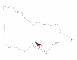 |
The sunklands comprises four discrete types of land, coastal plains with ridges and dunes, alluvial plains, former swamps and wetlands and coastal dunefields
Related information on VRO
- West Gippsland Soil/Landform Mapping
- A Study of the Land in the Catchment of the Gippsland Lakes, Volume 1 (J.M. Aldrick et al 1988)
- A Study of the Land in the Catchment of the Gippsland Lakes, Volume 2 (J.M. Aldrick et al 1988)
- A Classification of Lands at Wilson's Promontory - Second Edition, Technical Report No. 43 (G. T. Sibley and D. B. Rees 1999)
- Shire of Traralgon - Broad-scale Land Capability Assessment (M R Wells 1979)
Further reading
Keeble R. A. 1950. The Mornington Peninsula. Memoirs of the Geological Survey of Victoria. 17, 1-84.
Hills E.S. 1942. The physiography of the Koo-Wee-Rup Swamp. Proceedings of the Royal Society of Victoria 54 (NS), 79-91.
Spencer-Jones D, Marsden M A H, Barton C M & Carrillo Rivera J J. 1975. Geology of the Westernport Sunkland. Proceedings of the Royal Society of Victoria 87, 43-67.
© State of Victoria (Agriculture Victoria) 1996 - .

This work, Victorian Resources Online, is licensed under a Creative Commons Attribution 4.0 licence. You are free to re-use the work under that licence, on the condition that you credit the State of Victoria (Agriculture Victoria) as author, indicate if changes were made and comply with the other licence terms.
The licence does not apply to ‘branding’ or some ‘images or photographs’ that may be owned by third parties. We ask you to seek prior approval to use images using the VRO feedback form. Access to higher quality images can also be provided on request.
This page was last updated on .