
6.1.3 Plains with poorly developed drainage and shallow regolith (Wingeel)
6. Western Plains (WP)
6.1 Volcanic plains
| The plains developed on the older Newer Volcanic lavas that formed in the Late Pliocene and during the Pleistocene, from about two million year ago and up to one million years ago, are generally characterised by thin regolith development and poorly developed drainage. In these landscapes, flow boundaries are obvious, and corestones (‘floaters’) are often seen at the surface. Shallow drainage lines have developed, often along the boundaries of lava flows. Discontinuous drainage lines may end in ephemeral wetlands and swamps. Examples of this landform occur in the region from Warrambine to Armytage, with the best examples immediately north of the Wingeel Swamp. Associated soil types are sodic and non-sodic texture contrast (moderately deep to deep) soils (Sodosols) and some gradational (shallow to moderately deep) soils (Dermosols), and gilgai (mound and rise ground surfaces) due to swelling and shrinking clay soils can lead to road and building foundation problems. The regolith and associated soils of unit 6.1.3 have been described as the Dunkeld Regolith Landform Unit of Gibbons & Gill 1964, and Joyce 1999. | 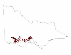 |
© State of Victoria (Agriculture Victoria) 1996 - .

This work, Victorian Resources Online, is licensed under a Creative Commons Attribution 4.0 licence. You are free to re-use the work under that licence, on the condition that you credit the State of Victoria (Agriculture Victoria) as author, indicate if changes were made and comply with the other licence terms.
The licence does not apply to ‘branding’ or some ‘images or photographs’ that may be owned by third parties. We ask you to seek prior approval to use images using the VRO feedback form. Access to higher quality images can also be provided on request.
This page was last updated on .