
5.5.2 Low ridge tops with remnant aeolian sands and oriented swales with lakes and lunettes (south of Little Desert)
5. North Western Dunefields and Plains (DP)
5.5 Ridges with sand, and flats (Goroke, Nhill)
| This unit is located in western Victoria, clearly bounded by the Big Desert to the north and the little Desert to the south. The South Australian border is the artificial western boundary and the Wimmera River Valley (Lowan Salt Valley) is the eastern boundary. Similar terrain is found to the south of the Little Desert. This unit is dominated by a series of parallel and sub-parallel ridges orientated NNW/SSE, interspersed with similarly aligned valleys or swales. This pattern is still discernible in the siliceous dunefield units (5.2) to the north and south. This landform pattern is at its most distinct in this unit with the relative relief of the ridges ranging from 10 to 60 m. The major ridges (Diapur/LawloitRange/Propodollah) have an amplitude of about 5km with slopes of up to 8%, while the smaller ridges have an amplitude of 2 km and slopes up to 5%. The larger ridges have a complex of components including elevated swales/valleys. The intervening valley floors may extend to plains in the west and nearer the eastern boundary. These valley floors are dominated by lagoonal deposits, which can be quite shallow as well as the occasional swamp. There is the occasional sandy dune. The ridges consist Parilla Sand (Tpp), ferruginised at the surface which are exposed on the larger ridges, while Woorinen Formation (Qw), calcareous sandy clay regolith material (parna) covers most of the smaller ridges. Reworking of the Parilla Sand crests has resulted in a younger unconsolidated silceous sand (Lowan Sand; Ql) on the crests and on the valley floors/plains. The valley floors have younger lagoonal deposits(Qrs) consisting of expansive (cracking) dark organic clays, which may be quite shallow at their edges. | 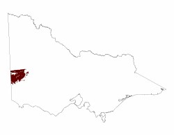 |
Sandy surfaced sodic texture contrast soils (Sodosols) and sandy soils (Rudosols, Tenosols) generally acidic occur on the Parilla Sand exposures while sodic (& calcareous) red texture contrast soils occur on the Woorinen Formation material, mainly on the smaller ridges. Grey and black cracking clay soils (Vertosols) formed on lagoonal deposits dominate the swales and valley floors.
Yellow Box is the dominant primary vegetation on the ridges with some casurinas also occur. The valley floors are dominated by Black Box as their primary vegetation.
Sheet erosion is relevant to any sloping terrain with water repellancy as an associated issue in this unit. Wind and gully erosion is a land degradation issue particularly relevant to the larger ridges. Water repellency and infiltration are issues on the red texture contrast soils particularly where surface soil horizons are shallow. Waterlogging may be an issue on the valley floors depending on rainfall events.
The Parilla Sand deposits provide roading material and a source of heavy minerals (see Geology of Victoria, Chapter14, pp449-454).
© State of Victoria (Agriculture Victoria) 1996 - .

This work, Victorian Resources Online, is licensed under a Creative Commons Attribution 4.0 licence. You are free to re-use the work under that licence, on the condition that you credit the State of Victoria (Agriculture Victoria) as author, indicate if changes were made and comply with the other licence terms.
The licence does not apply to ‘branding’ or some ‘images or photographs’ that may be owned by third parties. We ask you to seek prior approval to use images using the VRO feedback form. Access to higher quality images can also be provided on request.
This page was last updated on .