
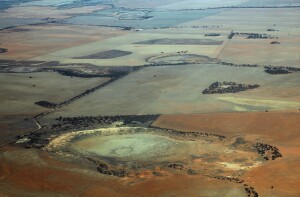
5.3.2 Palaeolacustrine depressions (north of Lake Tyrrell, east of Sunset Strip)
5. North Western Dunefields and Plains (DP)
5.3 Depressions
| Clay plains frequently occur at slightly higher elevations than the boinkas. Such plains are extensive to the north and west of Lake Tyrrell and to the north-west, south-west and south of the Raak Plain. Gilgaied grey clays with subsoil gypsum predominate, grading with depth to coarsely-mottled red, white and grey clays. These highly weathered profiles have developed on Blanchetown Clay. The original vegetation is distinctive, being tall open mallee. Thus, boundaries to adjacent units are clear. The clays are partly buried in several areas, mostly by aeolian materials. To the south-west of the Raak Plain there are some large plains enclosed and separated mostly by siliceous dunefields. The vegetation is distinctive, consisting of grassland, woodland of Pine, Belah, Buloke and tall mallee with halophytic shrub understorey. There are occasional salinas. In addition to the grey clay soils (Vertosols) there are red Sodosols apparently formed in a veneer of parna. There are also sandy plains and low dunes derived from adjacent areas of Lowan Sand and Woorinen Formation, probably redistributed by the incursion of floodwaters. Extensive plains to the south-west of Mildura are terraced. Grey Vertosols and Red Sodosols occupy the lower levels which support grasslands and woodlands of belah with halophytic shrub understorey. The higher levels are composed of Bungunnia Limestone deposited as Lake Bungunnia finally dried up. Grey brown Calcarosols with fine-earth lime to the surface overlie nodular limestone. Vegetation is largely tall open mallee with halophytic shrubs. Limestone terraces have also been noted in the Tyrrell Depression, but here they are relatively subdued. | 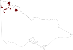 |
To the north and west of Lake Tyrrell, and to the south of the Raak Plain, grey clay plains predominate with occasional east-west linear dunes.
In the south of the Noora Depression there are several small, weakly-elongated depressions approximately 2 to 5 km in length. The surfaces are mostly yellowish red sands which appear to have been blown in from adjacent areas of Woorinen Formation and then levelled off when inundated. The vegetation is distinctive, being small mallee with Spinifex understorey.
Some of the unit has been cleared for agriculture, particularly the more southerly areas with higher rainfall. The grey clays are relatively stable, but they produce low yields because of low storage of available water and inherent salinity. The red Sodosols are particularly susceptible to wind erosion, forming sodic red clay scalds. The east-west dunes are highly susceptible to wind erosion.
© State of Victoria (Agriculture Victoria) 1996 - .

This work, Victorian Resources Online, is licensed under a Creative Commons Attribution 4.0 licence. You are free to re-use the work under that licence, on the condition that you credit the State of Victoria (Agriculture Victoria) as author, indicate if changes were made and comply with the other licence terms.
The licence does not apply to ‘branding’ or some ‘images or photographs’ that may be owned by third parties. We ask you to seek prior approval to use images using the VRO feedback form. Access to higher quality images can also be provided on request.
This page was last updated on .