
5.1.5 Hummocky dunes sub-dominant (south east of linear dunefields)
5. North Western Dunefields and Plains (DP)
5.1 Calcareous Dunefields
| Clusters of sub-round dunes occur on on broad gilgaied plains just beyond the southern and eastern margins of the Tyrrell Basin, at elevations of approximately 60 to 80 metres. Some areas contain subdued standline ridges, particularly to the west of Birchip. North east - south west ridges are common on the lower plains. Boundaries are unclear to unit 5.5.4, but clear to unit 5.5.6 with its linear dunes, and to alluvial plains of the Richardson River, Tyrrell Creek and Lalbert Creek. The plains on which the dunes occur are generally subdued with weakly-developed north west - south east ridges. Low hummocky dunes occupy about one quarter of the unit. Tending to occur in clusters which may be as much as 3 kilometres across. Low hummocky dunes occupy about one quarter of the unit. On subdued plains they tend to occur in clusters which may be as much as 3 km across. The pattern may reflect variation in the clay content of the underlying weathered Parilla Sand. | 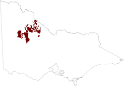 |
Gilgaied clays (Vertosols) are the most widespread soils, occupying the broad subdued plains, the elongated plains between stranded ridges and the lower slopes of dunes and ridges. Medium-textured calcarosols occur on the upper slopes of dunes and ridges.
Agricultural production is lowered on the clay soils by limited penetration of rainwater and by inherent salinity and sodicity of the gilgai puffs. These effects increase with increasing aridity towards the north. The wind erosion hazard is high only on upper western dune slopes. Seepage salinity has not been noted.
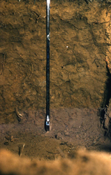 Vertosol in gilgai shelf on plain in southern Mallee | 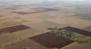 |
© State of Victoria (Agriculture Victoria) 1996 - .

This work, Victorian Resources Online, is licensed under a Creative Commons Attribution 4.0 licence. You are free to re-use the work under that licence, on the condition that you credit the State of Victoria (Agriculture Victoria) as author, indicate if changes were made and comply with the other licence terms.
The licence does not apply to ‘branding’ or some ‘images or photographs’ that may be owned by third parties. We ask you to seek prior approval to use images using the VRO feedback form. Access to higher quality images can also be provided on request.
This page was last updated on .