
5.1 Calcareous dunefields
5. North Western Dunefields and Plains (DP)
5.1.1 - Linear dunes dominant (north, south and east of Sunset Desert)
5.1.2 - Linear dunes co-dominant (north and east of Big Desert, south of Millewa)
5.1.3 - Linear dunes sub-dominant (mostly south east of Big Desert, Millewa)
5.1.4 - Hummocky dunes dominant (south east of Lake Tyrell, north and south of Lake Hindmarsh)
5.1.5 - Hummocky dunes sub-dominant (south east of linear dunefields)
| Calcareous dunefields cover about two-thirds of the Mallee, on plains with stranded ridges of variable prominence. East-west dunes predominate, but in the southern Mallee there are subdued, sub-round, hummocky forms. Wind erosion of lacustrine, fluviatile and aeolian materials during the later Pleistocene arid periods produced a layered assemblege of soils. The modern soil is underlain by three or more palaeosols which were partly eroded before burial. The layers tend to parallel the land surface. Within each layer the contents of clay, carbonates and soluble salts increase from dune crest to swale. These materials constitute the Woorinen Formation which is characteristically two or more metres thick, usually overlying Blanchetown Clay, Parilla Sand, or Shepparton Formation. On the linear dunes, reddish yellow to yellowish red loose sands overlie compact sandy loam to sandy clay loam layers. Swales generally have reddish medium-textured soils with sandy loam to sandy clay loam surfaces, merging with depth to sandy clay or clay subsoils with abundant carbonates which may exceed one-third of the subsoil materials. Contents of soluble salts are typically high in subsoils of lower positions. Surface reaction tends to be neutral in the loose dune sands, but alkaline elsewhere. Surfaces are naturally friable and porous, but may be hardened by erosion and by over-cultivation. | 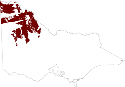 |
These reddish light and medium-textured Calcarosols occupy most of the dunefields. However, greyish gilgaied clay Vertosols predominate on plains and gentle ridge slopes in the southern Mallee, continuing on into the Wimmera. Carbonate contents are lower than those in the Calcarosols, but soluble salt contents are higher. The parent materials are thought to be “parna”, a fine-textured aeolian material deposited from suspension rather than by saltation. Some of the material could also be derived from the saltation of clay aggregates on inter-ridge plains, particularly in the south.
The formation of linear dunes from loamy and clayey materials is though to have been promoted by surface salinity in the lower situations during arid periods that initially had high watertables. Evaporation resulted in saline, loose surfaces susceptible to deflation. Sand particles and clay aggregates saltated to form dunes, apparently with little downwind movement.
References
Butler, B. E. 1956. Parna, an aeolian clay Aust. J. Sci. Vol 18:145-151
Butler, B. E. and Hutton, J. T. 1956. Parna in the Riverine Plain of south-eastern Australia and the soils thereon. Aust. J. Agric. Res. Vol 7:536-553.
Churchward, H. M. 1961. Soil studies at Swan Hill, Victoria, Australia. I Soil layering. J. Soil Sci. Vol 12. 73-86
Churchward, H. M. 1963a. II. Dune moulding and parna formation. Aust. J. Soil Res. Vol 1 103-116.
Churchward, H. M. 1963b. III. Some aspects of soil development on aeolian materials. Aust. J. Soil Res. Vol 1 117-128.
Churchward, H. M. 1963c. IV. Ground surface history and its expression in the array of soils. Aust. J. Soil Res. Vol 1 242-255.
Rowan, J. N. and Downes, R. G. 1963. A study of the land in north-western Victoria. Soil Conservation Authority, Victoria. Publ. No. TC2
Rowan, J. N. 1971. Salting on dryland farms in north-western Victoria. Soil Conservation Authority, Victoria. Publ. No. TC7
Related information on VRO
- A Study of the Land in North-western Victoria (J N Rowan and R G Downes 1963)
© State of Victoria (Agriculture Victoria) 1996 - .

This work, Victorian Resources Online, is licensed under a Creative Commons Attribution 4.0 licence. You are free to re-use the work under that licence, on the condition that you credit the State of Victoria (Agriculture Victoria) as author, indicate if changes were made and comply with the other licence terms.
The licence does not apply to ‘branding’ or some ‘images or photographs’ that may be owned by third parties. We ask you to seek prior approval to use images using the VRO feedback form. Access to higher quality images can also be provided on request.
This page was last updated on .