
4.2 Older alluvial plains
- 4.2.1 Plains with leveed channels, sometimes source-bordering dunes (Tatura, Naneela)
- 4.2.2 Plains without leveed channels (Tragowel, Pine Grove)
- 4.2.3 Plains with lakes and depressions with lunettes (Lakes Mokoan, Bael Bael, Lake Tutchewop)
4. Northern Riverine Plain (RP)
4.2.1 - Plains with leveed channels, sometimes source-bordering dunes (Tatura, Naneela)
4.2.2 - Plains without leveed channels (Tragowel, Pine Grove)
4.2.3 - Plains with lakes and depressions with lunettes (Lake Mokoan, Bael Bael, Lake Tutchewop)
| The older alluvial plains are not normally subject to flooding. All of the soils on these plains are derived from sediments deposited mainly during the Pleistocene (Late Neogene), which are collectively known as the Shepparton Formation. The sediments are believed to come from two sources: riverine deposits from distributary and divergent streams originating from the uplands and second and minor deposition of aeolian sediments or “parna” blown in from the west. Terraces, alluvial fans and aprons of uncertain age occur along the edge of the uplands (4.3) and are generally higher in the landscape than the older alluvial plains. Parna differs from loess in America, Europe and Asia in that it is calcareous and more clayey. During the Pleistocene, the climate cycled between pluvial (high rainfall) and arid phases. Alluvial deposition mostly occurred during periods of aridity, as soil fixed by vegetation in the uplands during the wetter periods became mobilised. At peaks of aridity, parna was blown in by prevailing winds from the west. Areas of parna near or at the surface are recognised east of the Loddon River but are not apparent in the western parts of the older alluvial plains around Horsham. It is convenient to subdivide the older alluvial plains into three subdivisions on the basis of easily recognisable landscape features, plains with leveed channels associated with now defunct stream systems known as prior streams (4.2.1), plains without leveed channels (4.2.2) and lakes and basins with lunettes within the older alluvial plains (4.2.3). | 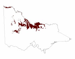 |
Most of the plains with leveed channels (4.2.1) are formed on sediments derived from earlier prior streams associated with the former courses of the Murray and Goulburn Rivers and to a lesser extent the Campaspe, Loddon, Avoca and Wimmera Rivers. The areal extent of the plains with leveed channels associated with each catchment appears to be related to the catchment area and rainfall, with the area associated with the Murray River being the most extensive and those of the Avoca and Wimmera Rivers the least extensive. Most of the area of plains with leveed channels associated with the Murray River lies in New South Wales. In Victoria, these plains are largely irrigated, with the lighter textured soils supporting high value horticultural crops.
The distal courses of the prior streams associated with the Campaspe, Loddon, Avoca and Wimmera Rivers fade into the plains without channels (4.2.2), although there are weak drainage systems within them that become active after heavy rain. Plains with terminal lakes and basins with lunettes (4.2.3) occur within the older alluvial plains associated with the Wimmera, Avoca and Loddon Rivers.
The present climate ranges from semi-arid to sub-humid with a pronounced winter maximum. Brown and red texture contrast soils (Sodosols) predominate on the plains with leveed channels. Shallow Sodosols and grey and red Vertosols mainly occur on the plains without channels. Generally the plains with leveed channels supported box woodland, with grey box and casuarinas occurring on the heavier textured soils and yellow box and native pine on the levees. Black box may occur in the depressions, mainly in the Wimmera.
Related information on VRO
- Land Inventory of the Loddon River Catchment - a reconnaissance survey (N Schoknecht 1988)
- A Study of the Land in the Campaspe River Catchment (M. S. Lorimer and N. R. Schoknecht 1987)
- A Study of the Land in the catchments of the upper Ovens and King Rivers - TC-16 (R. K. Rowe 1984)
© State of Victoria (Agriculture Victoria) 1996 - .

This work, Victorian Resources Online, is licensed under a Creative Commons Attribution 4.0 licence. You are free to re-use the work under that licence, on the condition that you credit the State of Victoria (Agriculture Victoria) as author, indicate if changes were made and comply with the other licence terms.
The licence does not apply to ‘branding’ or some ‘images or photographs’ that may be owned by third parties. We ask you to seek prior approval to use images using the VRO feedback form. Access to higher quality images can also be provided on request.
This page was last updated on .