
4.1.2 Areas of inundation away from modern channels (Gunbower, Forest, Dingee swamps, Loddon fan, Carag Carag)
4. Northern Riverine Plain (RP)
4.1 - Modern floodplains
| Several former courses of the major rivers, such as the Murray and Goulburn, are marked by extensive meander belts and source-bordering dunes, often with associated Red Gum forests, and occur in shallow depressions below the plains, such as the Gunbower Forest. Commonly these have associated Re gum forests in shallow depressions below the plains, such as the Gunbower Forest, or on broad, occasionally inundated fans such as the Loddon Fan. These younger incised channels were formerly referred to as ancestral rivers (Pels, 1964b). Extensive meander belts and source-bordering dunes that occur in a broad swale north of Warracknabeal note a former course of the Yarriambiack River. These younger incised channels were formerly referred to as ancestral rivers (Pels 1964b). Soils vary on these plains where regolith consisting of sands, loams and clays have accumulated. The major soils include sodic, grey texture contrast soils (grey Sodosols) and cracking clay soils (Vertosols). | 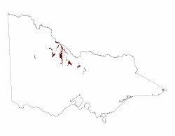 |
The texture contrast soils have slightly acidic sandy clay loam surfaces over grey light clays that increase in sodicity with depth. Minor carbonate occurs in the subsoil. The cracking clays are acidic at the surface with light clays clearly changing to heavy clay subsoils that can be more acidic at depth and very few carbonate nodules. Depths for all soils are generally in excess of 2 metres.
Vegetation is dominated by Red Gums as the major overstorey species. Vegetation communities along these floodplains include a variety of woodlands including Plains Woodland and Drainage-line Woodland.
Flooding provides a hazard for this unit but usually only after the modern channels have flooded.
© State of Victoria (Agriculture Victoria) 1996 - .

This work, Victorian Resources Online, is licensed under a Creative Commons Attribution 4.0 licence. You are free to re-use the work under that licence, on the condition that you credit the State of Victoria (Agriculture Victoria) as author, indicate if changes were made and comply with the other licence terms.
The licence does not apply to ‘branding’ or some ‘images or photographs’ that may be owned by third parties. We ask you to seek prior approval to use images using the VRO feedback form. Access to higher quality images can also be provided on request.
This page was last updated on .